Best Road Trips in Albania
We pulled over at the Llogara Pass on a cloudless June morning, stepped out of the car, and realized we could see the island of Corfu floating in the Ionian Sea below us while standing on a mountainside that felt like the Swiss Alps. That is Albania’s trick: it compresses an absurd variety of landscapes into a country smaller than Belgium. In the time it takes to drive from one end to the other, you pass through Mediterranean coastlines, Ottoman-era towns frozen in time, mountain ranges that belong in a Tolkien novel, and lakeshores that rival anything in Italy or Greece.
These are four routes we have driven personally, mapped with specific stops, distances, and the kind of practical details that trip-planning websites usually skip. Each one can be done as a standalone trip or combined into a longer Albanian circuit.
Route 1: The Albanian Riviera (Vlore to Sarande, 150 km, 4-5 hours)
This is the route most people come to Albania for, and it earns its reputation. The SH8 coastal road from Vlore to Sarande is one of Europe’s most spectacular drives, climbing over the Llogara Pass at 1,027 meters before descending through a series of cliff-hugging switchbacks to the Ionian coast.
Starting point: Vlore. The city itself is not Albania’s most charming, but the waterfront promenade is pleasant and the seafood restaurants along the Lungomare are excellent. Fill up the tank here — gas stations become scarce once you hit the mountain section. A coffee and a byrek (savory pastry) from one of the bakeries on Rruga Mitat Hoxha makes a good start to the drive.
Kilometer 0-30: Vlore to Llogara Pass. The road climbs steadily through pine forests, gaining over 1,000 meters of elevation. The final approach to the pass is a series of tight switchbacks. At the top, there is a small restaurant and a viewpoint with panoramic views of the coast below. Stop here. Breathe. This is the kind of view you remember for years. On the clearest days, you can see the island of Corfu, 15 km across the water.
The Llogara National Park surrounds the pass. The pines are tall and the air is cool even in summer — bring a layer if you are driving in July, because the summit temperature can be 15 degrees cooler than Vlore. There is a small hiking area near the viewpoint for those who want to stretch their legs.
Kilometer 30-55: Llogara to Dhermi. The descent from the pass is dramatic — the road drops steeply toward the coast with views that compete with anything on the Amalfi Coast. Dhermi Beach is your first major stop. The beach is long, pebbly in places, sandy in others, and the water is the kind of transparent blue that looks photoshopped. A sunbed and umbrella runs 400-600 ALL ($4-6) from the beach clubs. The village of Dhermi above the beach has a Byzantine church (Shën Vasili) and some of Albania’s best breakfast spots.
Kilometer 55-80: Dhermi to Himara. Continue along the coast through small villages. Gjipe Beach is accessible via a 30-minute walk from a marked turnoff — it is worth the detour if you have time. The beach sits in a dramatic canyon and is one of Albania’s most photogenic spots. Himara is a good lunch stop with several waterfront restaurants. Try the grilled octopus at one of the places along the Spilia Beach boardwalk (800-1,200 ALL / $8-12 for a full meal). The old village of Himara sits above the modern town and has remnants of Byzantine fortifications with excellent views.
Kilometer 80-110: Himara to Porto Palermo. The road hugs the coast more tightly here. Porto Palermo has an Ottoman fortress (Ali Pasha Castle) sitting on a small peninsula — a quick 20-minute stop. The views from the castle walls over the bay are superb. Ali Pasha of Ioannina, one of the more colorful Ottoman administrators of the 19th century, built this fortress as a combination military base and pleasure palace. The combination of crystal water, cypress trees, and old stone walls is genuinely striking.
Borsh Beach, just south of the castle, stretches for 7 km — the longest beach in Albania. It is backed by olive groves and is significantly quieter than Dhermi or Himara. The town of Borsh itself is known for its olive oil, and you can buy fresh oil from small producers for 600-1,000 ALL ($6-10) per liter.
Kilometer 110-150: Porto Palermo to Sarande. The final stretch passes through Lukove, Ksamil villages, and several smaller coves before reaching Sarande. The city is Albania’s main resort town — lively, slightly chaotic, and a good base for exploring Ksamil and the ruins at Butrint.
Side trip: Ksamil and Butrint (20 km from Sarande). Drive the extra 20 minutes south to Ksamil for Albania’s most famous beaches — small, white-sand crescents facing three tiny islands. The water is shallow and calm and the color is remarkable. Continue another 10 minutes to Butrint National Park (700 ALL / $7 entry), a UNESCO World Heritage Site with Greek, Roman, Byzantine, and Venetian ruins set in a lush subtropical landscape. The site sits on a peninsula at the edge of a lagoon and takes about two hours to explore properly.
Route 1 Details
| Segment | Distance | Time | Road Quality |
|---|---|---|---|
| Vlore to Llogara Pass | 30 km | 45 min | Good, steep switchbacks |
| Llogara to Dhermi | 25 km | 35 min | Good, steep descent |
| Dhermi to Himara | 25 km | 30 min | Good, coastal curves |
| Himara to Porto Palermo | 30 km | 35 min | Good to fair |
| Porto Palermo to Sarande | 40 km | 50 min | Good |
| Total | 150 km | 4-5 hours (with stops) |
Best Stops on the Riviera
| Stop | Distance from Vlore | What to Do | Time Needed |
|---|---|---|---|
| Llogara Pass viewpoint | 30 km | Views, photos, coffee | 20-30 min |
| Dhermi Beach | 55 km | Swimming, lunch | 1-3 hours |
| Gjipe Beach (walk) | 60 km | Canyon beach hike | 1.5 hours |
| Himara waterfront | 80 km | Lunch, old village | 1-2 hours |
| Ali Pasha Castle | 100 km | Ottoman fortress tour | 30 min |
| Ksamil beaches | 155 km | Swimming, kayaking | 2-4 hours |
| Butrint ruins | 160 km | UNESCO archaeological site | 2 hours |
Common Mistakes on the Riviera Route
Going too fast. The SH8 from Vlore to Sarande is not a transit road — it is the destination. We have seen travelers rush the whole thing in 2 hours without stopping and wonder afterward why everyone else loved it. Allow a full day minimum, preferably two nights on the coast.
Not filling up in Vlore. Between Vlore and Sarande, the gas stations are few and overpriced compared to city rates. Fill the tank completely before leaving Vlore. There is an Europetrol on the southern outskirts, 2 km before the road starts climbing toward Llogara.
Driving the switchbacks in a hurry. The SH8 through the Llogara section and the descents toward Dhermi have tight switchbacks that require smooth, deliberate driving. Tourists who drive them like a race track tend to encounter oncoming buses on blind corners. Drive smoothly, honk before blind turns, and let faster locals pass when there is a safe section to do so.
Ignoring the off-peak hours. In July and August, the coastal road from Himara to Sarande can get backed up with tour buses and Riviera-bound traffic between 11:00 and 17:00. Drive the scenic section early (departing Vlore before 08:00) or in the late afternoon (after 17:00) for a clearer road and better light for photos.
Route 2: The UNESCO Triangle — Berat, Gjirokaster, and Sarande (350 km loop, 2-3 days)
Albania has three UNESCO World Heritage Sites, and this loop connects two of the most impressive — the “City of a Thousand Windows” (Berat) and the “City of Stone” (Gjirokaster) — with the coastal gateway of Sarande.
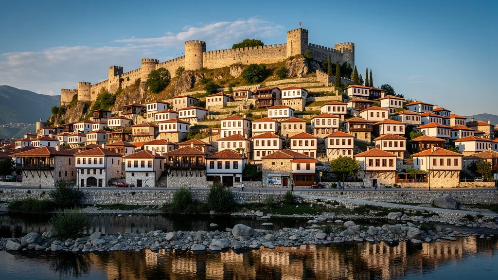
Day 1: Tirana to Berat (120 km, 2 hours). Take the SH3 south through Elbasan or the more direct road via Lushnje. Berat is one of Albania’s most photogenic towns: Ottoman houses stacked up a hillside, reflected in the Osum River below. The town is divided into three neighborhoods: Mangalemi (the Muslim quarter, full of white-walled houses with black shutters), Gorica (across the river, connected by an old bridge), and Kalaja (the castle area on the hill).
Walk up to the Kalaja (castle), which is still inhabited — people live in centuries-old houses within the fortress walls. The National Iconographic Museum inside the castle holds a remarkable collection of Byzantine icons. The views from the walls over the river valley and the town below are excellent. Spend the night in the Mangalemi quarter — several old houses have been converted into guesthouses (3,000-6,000 ALL / $29-58 per night).
Berat’s restaurant scene is better than you might expect for a town this small. Taverna Mangalemi in the old quarter serves traditional dishes — try the ferges (a lamb and vegetable stew) and the local wine from the Berat wine region. Budget 1,500-2,500 ALL ($15-24) for dinner.
Day 2: Berat to Gjirokaster (130 km, 2.5 hours). Drive south through Fier and Tepelene. The approach to Gjirokaster is stunning — the city appears on a hillside beneath a massive fortress. Gjirokaster is denser and more austere than Berat, all gray stone houses with distinctive slate roofs climbing steeply up the hillside.
Gjirokaster’s Bazaar is a labyrinth of cobblestone streets, stone houses, and craft shops. The castle itself houses a military museum and, improbably, an American U-2 spy plane shot down in 1960. The views from the castle walls over the Drinos River valley and toward Greece are extraordinary. The writer Ismail Kadare was born here, and a small museum in his childhood home tells the story of both the man and the city.
Overnight in one of the converted stone houses in the old town — they are unique accommodation and the views from the upper rooms are remarkable. The Old Bazaar area has several good restaurants serving Gjirokaster specialties, including the distinctive local qifqi (rice balls fried with herbs).
Day 3: Gjirokaster to Sarande and back to Tirana (100 km to Sarande, then 280 km back to Tirana). The drive from Gjirokaster to Sarande takes about 1.5 hours through the Drinos Valley. Spend the morning in Sarande or Ksamil, then return to Tirana via the A2 highway through Fier — this route is faster than the coastal road.
Detour: Blue Eye (Syri i Kalter). Between Gjirokaster and Sarande, a signed turnoff leads 15 km off the main route to the Blue Eye spring, a natural phenomenon where water of an almost unreal blue bubbles up from an underground river. The entry fee is 100 ALL ($1) and the visit takes about 45 minutes. The walk from the car park to the spring follows a shaded river path through dense forest. The spring itself is striking — a disc of impossibly blue water, approximately 50 meters across, pulsing gently from the aquifer below. Go.
Route 2 Details
| Segment | Distance | Time | Highlights |
|---|---|---|---|
| Tirana to Berat | 120 km | 2 hours | Osum River valley |
| Berat to Gjirokaster | 130 km | 2.5 hours | Drinos Valley, Tepelene |
| Gjirokaster to Sarande | 100 km | 1.5 hours | Blue Eye Spring (detour) |
| Sarande to Tirana (via A2) | 280 km | 4 hours | Fast highway return |
UNESCO Route Parking Notes
Berat: The new parking area below the Mangalemi quarter is the best approach — free, and avoids the steep narrow streets. Walking up is 15 minutes. Within the Kalaja (castle area), driving is possible but the alleys are very narrow and the surface is cobbled. Park at the base and walk.
Gjirokaster: The old town has a designated car park at the Bazaar entrance — 100-200 ALL ($1-2) per hour. The castle is a 15-minute walk uphill from the car park. Do not try to drive to the castle — the road becomes a footpath partway up.
Sarande: Parking in Sarande is chaotic in July-August. Use the seafront promenade lots (paid, 100-200 ALL/hr) or the free streets behind the tourist strip. Ksamil has beach parking available for 200-300 ALL per day.
Route 3: The Northern Alps — Shkoder to Theth and Valbona (120 km, 3-4 days)
This is Albania’s adventure route. The Albanian Alps (Accursed Mountains) in the north are some of the most rugged and least-visited mountains in Europe. The roads match the terrain — expect gravel, steep grades, and zero guardrails in places. An SUV is not optional here; it is mandatory.
Day 1: Tirana to Shkoder (120 km, 1.5 hours via highway). The A1 highway north to Shkoder is Albania’s best road. Shkoder itself is a charming lakeside city — the largest city in northern Albania, with a relaxed, slightly different character from the south. The Rozafa Castle above the city has views over Lake Shkoder (the largest lake in the Balkans) and into Montenegro. The old town is pleasant for an evening walk. Have dinner at one of the fish restaurants near the lake — the carp from Lake Shkoder is a local specialty.
Day 2: Shkoder to Theth (70 km, 3 hours). This is where it gets real. Leave Shkoder early — the road to Theth can be shared by trucks delivering supplies to the village, and passing them on narrow mountain roads is not ideal. The route goes via Bogë and climbs continuously into the mountains.
The scenery — deep valleys, waterfalls, stone tower houses (kulla) used historically for blood feuds — is world-class. Theth itself is a tiny mountain village of perhaps 100 permanent residents. In summer, trekkers arrive via the hiking trail from Valbona, and the guesthouses fill up. The Grunas Waterfall (3 km from the village center) is a 30-meter cascade through a limestone canyon. The Blue Eye of Theth (different from the southern one near Gjirokaster) is a cold spring pool in the forest. The Lock-in Tower (Kulla e Ngujimit) is a restored blood feud confinement tower now serving as a museum.
Book guesthouses in Theth in advance for July and August — there are maybe 10-15 places, all family-run, all serving homemade food. Expect to pay 3,000-5,000 ALL ($29-48) for a room and dinner.
Day 3: Theth to Valbona (hike or return and drive). The classic Theth-to-Valbona hike takes 6-7 hours over the Valbona Pass (1,795 m). It is one of the best day hikes in the Balkans — alpine scenery, dramatic ridgelines, and remarkable solitude even in summer. If you are doing it, start before 08:00.
If you prefer driving, you will need to return to Shkoder and take the road to Fierze, then the Koman Lake ferry (a spectacular experience in itself), and finally drive to Valbona from the other side. This is a full day of travel, but the ferry makes it worthwhile.
Day 4: Valbona to Shkoder via Koman Ferry. The ferry across Lake Koman is one of Albania’s most iconic experiences — three hours through a narrow canyon that looks like a Norwegian fjord but narrower. The ferry is a working passenger and cargo boat that has been running this route for decades. Book in advance during summer (2,000 ALL / $19 per person, 5,000 ALL / $48 for a car). The departure from Koman is at 09:00 (verify current schedule). Arrive 30 minutes early.
After the ferry, the road from Fierze back to Shkoder (100 km, about 2 hours) is straightforward and gives you time to reflect on the mountains you just traversed.
Route 3 Details
| Segment | Distance | Time | Notes |
|---|---|---|---|
| Tirana to Shkoder | 120 km | 1.5 hours | Highway A1 |
| Shkoder to Theth | 70 km | 3 hours | Last section unpaved, SUV required |
| Theth to Valbona (hike) | 14 km | 6-7 hours | On foot, trail |
| Koman Ferry | — | 3 hours | Book in advance |
| Fierze to Shkoder | 100 km | 2 hours | Via SH5 |
What to Pack for the Northern Route
The Albanian Alps have their own microclimate. Afternoon thunderstorms are common from June through August. Pack waterproofs even in peak summer. Temperatures at altitude (the Valbona Pass is at 1,795 m) can be 10-15 degrees cooler than the lowlands. Hiking boots are essential if you plan to walk the Theth-Valbona trail.
For the car, bring:
- A full spare tire (not a repair kit — gravel roads puncture tires properly)
- Extra water (2-3 liters minimum)
- Snacks for the mountain section where stops are nonexistent
- Offline maps downloaded before leaving Shkoder
- A basic first aid kit
- Emergency contact number for your rental agency
Road Notes for the Northern Route
The SH5 from Shkoder to Fierze (for the Koman ferry) is paved but has serious sections of deterioration in places. Your SUV will handle it, but a standard economy car will be slower and more stressful. The turn-off for the Koman ferry jetty is about 2 km before the Fierze town proper — follow signs for “Tragetti Koman” (Koman Ferry).
The road into Theth from Bogë is a combination of rough asphalt and gravel. After rain, some sections become muddy. The route is impassable in winter (roughly November to April). In early June, verify current conditions before committing — late snowmelt occasionally blocks the higher sections.
Route 4: Lake Ohrid and the Southeast (Tirana to Korce loop, 400 km, 2 days)
The southeast corner of Albania is the part most tourists miss, which is a shame because it holds some of the country’s most atmospheric towns and the Albanian shore of Lake Ohrid, a UNESCO-listed lake shared with North Macedonia.
Day 1: Tirana to Pogradec via Elbasan (140 km, 2.5 hours). Take the A3 to Elbasan, a mid-sized industrial city that most tourists skip. There is a well-preserved Ottoman-era bazaar (Çarshia e Vogël) in the center that is worth 30 minutes. Continue southeast on the SH3 to Pogradec. The approach to Pogradec as the road descends toward Lake Ohrid is one of Albania’s better views.
The town sits on the western shore of Lake Ohrid, and the water is so clear you can see the bottom at 20 meters. The lake is at 693 meters elevation — the air is noticeably cleaner than in the lowlands. Have a meal at one of the lakeside restaurants — grilled Ohrid trout (koran) is the specialty (600-900 ALL / $6-9 for a full serving). The trout in Lake Ohrid is a distinct species that lives only in this lake and Lake Prespa, and it is genuinely delicious.
Pogradec’s beach area is pleasant for an evening walk. The promenade has a relaxed, slightly faded charm — it was a popular resort town in the communist era and some of that old-fashioned seaside atmosphere persists.
Day 2: Pogradec to Korce to Tirana (260 km, 4.5 hours total). The drive from Pogradec to Korce (50 km, 45 minutes) passes through mountain territory and crosses a watershed between Lake Ohrid and the interior. Korce is Albania’s cultural capital of the southeast — a city of wide boulevards, elegant old buildings, and the best beer in the country (Birra Korce, brewed locally since 1928). The Korce Bazaar and the National Museum of Medieval Art are worth a couple of hours. The museum holds an exceptional collection of icons from the 13th through 19th centuries.
Return to Tirana via the SH3 and A3 (210 km, about 3 hours). The road via Elbasan is faster than going through Berat.
Detour: Voskopoje. From Korce, drive 20 km west to this once-wealthy trading village that had 35 churches in the 18th century. Several survive with remarkable frescoes — the Church of Saint Nicholas has one of the best-preserved 18th-century fresco cycles in the Balkans. The road is narrow but paved. The village itself is tiny and very quiet, which makes the grandeur of the surviving churches even more striking.
Detour: Lake Prespa. From Korce, it is 50 km south to the shores of Lake Prespa (via Liqenas). The lake sits at 853 meters and straddles three countries — Albania, North Macedonia, and Greece. The Albanian shore is largely undeveloped and very quiet. The views of the Pelister massif across the water are excellent. A pelican colony nests on the small islands in the lake.
Route 4 Details
| Segment | Distance | Time | Highlights |
|---|---|---|---|
| Tirana to Elbasan | 55 km | 50 min | A3 highway |
| Elbasan to Pogradec | 85 km | 1.5 hours | Mountain crossing |
| Pogradec to Korce | 50 km | 45 min | Lake views |
| Korce to Tirana | 210 km | 3 hours | Via Elbasan and A3 |
Southeast Route Hidden Gems
The A3 highway from Tirana to Elbasan passes through the Elbasan mountain tunnel — one of Albania’s most impressive recent infrastructure achievements. The tunnel replaced an old mountain pass road that was notoriously slow and dangerous in winter. The modern A3 is genuinely enjoyable to drive: wide, smooth, and fast.
The road from Elbasan to Pogradec via Librazhd passes through the Mat River valley before climbing into the mountains above Lake Ohrid. The valley section is one of Albania’s most scenic highway drives — a wide river flanked by steep forested hillsides. Stop at the Librazhd gorge viewpoint (marked with a small sign, 65 km from Tirana) for a photograph.
Route Comparison Table
| Route | Distance | Duration | Difficulty | Best Season | Highlights |
|---|---|---|---|---|---|
| Albanian Riviera | 150 km | 1 day | Easy-Moderate | May-Oct | Beaches, Llogara Pass, Ksamil |
| UNESCO Triangle | 350 km | 2-3 days | Easy | Apr-Nov | Berat, Gjirokaster, Blue Eye |
| Northern Alps | 300+ km | 3-4 days | Difficult | Jun-Sep | Theth, Valbona, Koman Ferry |
| Lake Ohrid Loop | 400 km | 2 days | Easy | Apr-Oct | Lake Ohrid, Korce, Voskopoje |
Planning Your Road Trip
Combine wisely. The Riviera route and the UNESCO Triangle can be combined into a single week-long trip from Tirana. Add the Northern Alps if you have 10-14 days and want to see everything.
Book accommodation in advance during July-August. The Riviera fills up, Theth guesthouses sell out, and even Sarande can get tight. In shoulder season, you can usually find rooms on arrival. Berat and Gjirokaster have good options year-round but book the best-reviewed places early.
Fill up before mountain sections. Gas stations thin out dramatically in the north and on mountain roads. Keep the tank above half when leaving major towns. Vlore is the last reliable fill-up before the Riviera. Shkoder is the last reliable fill-up before Theth.
Download offline maps. Google Maps works well in Albania, but cellular coverage drops in the mountains. Download the Albania map region before you leave your hotel. The Maps.me app is a solid backup for mountain areas.
Budget for the unexpected. Albanian road trips deliver surprises — a hidden beach you did not plan for, a village festival with live music and free raki, a castle ruin on a hillside that is not in any guidebook. Leave room in your schedule for spontaneous detours. We have added 50 km to driving days on more than one occasion for something we stumbled onto.
Drive times are conservative. The times above account for stops and realistic driving speeds on Albanian roads. On the coastal route, traffic in summer can add 30-45 minutes to the Sarande-area section. On mountain roads, driving slower than you think necessary is always the right call.
Comparing Albania to Neighboring Destinations
Travelers often ask how Albania’s driving experience compares to its neighbors. The honest answer: Albania is more adventurous but more rewarding.
| Factor | Albania | Montenegro | North Macedonia | Greece |
|---|---|---|---|---|
| Coastal scenery | Exceptional (Riviera) | Good (Bay of Kotor) | Inland only | Good |
| Mountain roads | Challenging to adventurous | Moderate | Easy-moderate | Easy |
| Road quality | Variable | Good | Good | Good |
| Cost | Very low | Moderate | Low | Moderate-high |
| Crowds | Low-Moderate | High in summer | Low | High in summer |
| Uniqueness | Very high | Moderate | High | Low in tourist areas |
Albania wins on value, uniqueness, and the northern mountain circuit. Montenegro beats Albania on road quality and ease of navigation. North Macedonia wins for lake scenery and archaeology (Ohrid town itself is worth crossing the border for).
For specific driving rules and road conditions, check our Albania driving guide. For a general approach to planning road trips abroad, see our road trip planning guide. And if you are thinking about extending into North Macedonia for the other side of Lake Ohrid, our Montenegro best routes guide covers the coastal neighbor nicely.