Best Road Trips in Bosnia and Herzegovina
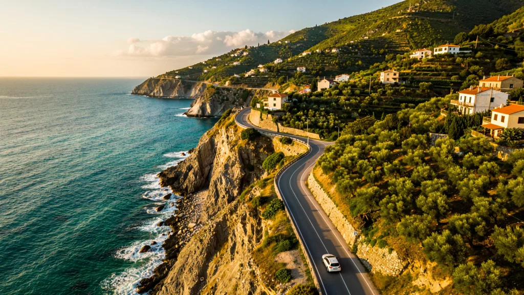
The old road from Sarajevo to Mostar is one of those drives that makes you understand why people rent cars instead of buying bus tickets. The M17 follows the Neretva River through a limestone gorge, the water below shifting between emerald green and impossible turquoise, while the road twists past medieval towers, Ottoman bridges, and tiny riverside settlements where the only commerce is a man selling homemade cheese from a folding table. We stopped five times in 130 km. The bus would have stopped zero times.
Bosnia and Herzegovina is a country that was designed for road trips, even if unintentionally. The mountains prevent straight-line highways, forcing every road to curve along rivers, through valleys, and over passes. The result is that getting anywhere in BiH is scenic. There is no boring stretch. The only question is which flavor of spectacular you prefer: the Neretva gorge, the waterfalls of the Una, the Mediterranean light of Herzegovina, or the mountain villages that the 20th century nearly bypassed entirely.
Route 1: The Neretva Valley — Sarajevo to Mostar (130 km, 2.5-4 hours)
This is the essential Bosnia drive. Everyone who rents a car in BiH drives this route, and everyone agrees it was worth it. The new A1 motorway covers the route quickly with tolls (10-15 BAM / $6-8, about 1.5 hours), but the old M17 road along the Neretva River is the one worth driving. Take the M17. Take your time.
Start: Sarajevo, Old Town (Bascarsija). Begin with a Bosnian coffee at one of the copper-service cafes on Bascarsija square — the ritual preparation (small brass pot, side glass of water, sugar cube) sets the pace for the day. Head south on the M17.
Kilometer 0-60: Sarajevo to Konjic
The road climbs out of the Sarajevo valley through the suburb of Ilidza and then into forested mountains, steadily gaining altitude. The first significant stop is the town of Konjic, 60 km south, where the M17 meets the Neretva for the first time.
Konjic is a pleasant town with an Ottoman bridge (Stara Cuprija, built 1682) spanning the emerald Neretva. The old bridge was destroyed in the 1990s war and beautifully rebuilt in 2009 — it looks ancient because the rebuilders used the original design and materials. Worth 20 minutes and a short walk.
The unmissable stop near Konjic: Tito’s Bunker (D-0 ARK). Located in the hills above town, this was Yugoslavia’s nuclear-proof command center built in the late 1950s at a cost of $4.6 billion USD. It was the country’s most classified secret until 1992. The 6,000 square meter complex has been partially converted into a museum and art space. Tours run hourly. Entry: 20 BAM ($11). Budget 1-1.5 hours. One of the more surreal experiences in the Balkans.
Kilometer 60-85: Konjic to Jablanica — The Gorge
This 25-km stretch is where the scenery peaks. The M17 squeezes through a narrow gorge with the Neretva below in colors that should not exist in nature — an improbable emerald that shifts to turquoise depending on the light and depth. The road has been carved into the rock face in places, with drop-offs on one side and limestone cliffs on the other.
Jablanica at the end of the gorge section has two points of interest: the WWII Museum of the Battle of the Neretva, which covers the 1943 battle in which Partisan forces under Tito destroyed the bridge at Jablanica to prevent German forces from crossing (the destroyed bridge still stands as a monument — it was deliberately left in ruins), and the lake above the town (Jablanicko Jezero), good for a short stop and photos.
Kilometer 85-110: Jablanica to Pocitelj — The Opening
After the gorge, the Neretva Valley widens. Vineyards appear — this is the beginning of Herzegovina’s wine country, where the Mediterranean climate produces excellent reds and local spirits. The landscape is more golden and open than the dark gorge section.
Stop: Pocitelj. At kilometer 105, take the signed turn to Pocitelj, a perfectly preserved Ottoman fortress village climbing a hillside above the Neretva. The main tower (Kula) dates from the 15th century. The Hajji-Alija Mosque (rebuilt after wartime destruction) and the medresa (school) create a compact Ottoman townscape that genuinely looks like a film set — except it is fully inhabited. The climb to the tower is 5-10 minutes on stone steps. Views over the Neretva valley are excellent. Free entry. Budget 30-45 minutes.
Kilometer 110-130: Pocitelj to Mostar
The final stretch brings you past more villages, the turn for Capljina (BiH’s wine producing center), and eventually into Mostar. Park near the Musala Square or use the parking area near the Spanish Square — both are paid (2 BAM/hour) and close to the Old Bridge.
Mostar’s Stari Most (Old Bridge) is the trip’s centerpiece: a 16th-century Ottoman arch bridge over the Neretva, destroyed in 1993 and rebuilt in 2004 using original stone and methods. It is a UNESCO World Heritage Site. Watch the bridge divers (young men who leap into the Neretva for tips — 30-50 meters, impressive if slightly staged). Walk the cobblestone streets of the Old Town, eat at one of the riverside restaurants beneath the bridge (trout from the river, grilled lamb, local wines), and stay until sunset when the bridge glows gold.
Essential Mostar detour: Blagaj (10 km, 15 minutes south of Mostar). A Dervish monastery (tekija) built at the mouth of a cave where the Buna River emerges fully formed from a cliff face at 39 cubic meters per second. The setting is extraordinary — the blue-green river, the cave mouth, and the Ottoman monastery squeezed between the cliff and the water. Entry: 5 BAM ($3). One of the most photogenic places in Bosnia. Do not skip it.
Route 1 Complete Details
| Segment | Distance | Drive Time | Key Stops |
|---|---|---|---|
| Sarajevo to Konjic | 60 km | 1 hour | Konjic bridge, Tito’s Bunker |
| Konjic to Jablanica | 25 km | 30 min | Neretva Gorge, WWII museum |
| Jablanica to Pocitelj | 45 km | 45 min | Ottoman fortress village, vineyards |
| Pocitelj to Mostar | 25 km | 20 min | Old Bridge, Blagaj detour |
| Total | ~155 km | 3-4 hours driving | Half day to full day with stops |
Best time: Year-round, but May-October for outdoor enjoyment. The gorge section is spectacular in any season.
Route 2: The Una River — Bihac and Una National Park (500 km loop from Sarajevo, 2-3 days)
Northwestern Bosnia hides one of Europe’s most beautiful river systems. The Una River flows through canyons and meadows of impossible clarity, dropping over a series of waterfalls that rival Plitvice Lakes in Croatia — with a fraction of the crowds and none of the €40 entry fees. The road network in this corner of Bosnia is also improving, making this loop more accessible than it was even five years ago.
Day 1: Sarajevo to Jajce (160 km, 2.5 hours)
Head north from Sarajevo on the M5 toward Zenica. Zenica is an industrial city — pass through it without stopping. The valley beyond Zenica starts to become interesting as you approach Travnik.
Travnik (90 km from Sarajevo): The former seat of Ottoman viziers for Bosnia, which gives it an architectural character unlike any other Bosnian city. The hilltop Stari Grad fortress has excellent views over the mosque-filled town below. The market sells excellent local Travnik cheese (vlasicki sir) — a semi-soft cow’s milk cheese brined in whey, specific to this area and worth bringing home. The Plava Voda (Blue Water) spring is 2 km from the center — a shaded park built around a mountain spring, with restaurants that have been serving trout for generations. Budget 1-1.5 hours for Travnik.
Jajce (160 km from Sarajevo, 1 hour beyond Travnik): One of Bosnia’s most dramatic towns. A 22-meter waterfall drops into the Pliva River right in the center, at the point where the Pliva meets the Vrbas. The waterfalls are visible from a bridge that you simply drive over — the cascade is right below you. Beyond the falls, the medieval Jajce Fortress dominates the hill above town. Inside the fortress walls is a 15th-century Church of St. Luke and underground catacombs. Below the fortress, the Ottoman-era bazaar and mosques create the town center. Budget 2 hours for Jajce.
Day 1 Continued: Jajce to Bihac (170 km from Jajce, 2.5 hours)
Head northwest on the M5.1 through the Vrbas River valley. The road quality is variable on this section — good to adequate, with some rougher patches on regional connecting roads. Bihac is reached by early afternoon if you left Sarajevo in the morning.
Bihac is the gateway to Una National Park, a pleasant town on the Una River with a functioning old town (the Church of St. Anthony and the Fethija Mosque, a converted church that reflects Bihac’s Ottoman history). Good overnight base.
Day 2: Una National Park (Full Day)
Una National Park encompasses one of the most spectacular river systems in the Balkans. The Una River drops through a series of waterfalls as it crosses different limestone formations, creating cascades of varying height and width. The park covers 198 square kilometers of river, canyon, and forest.
Strbacki Buk waterfall: The park’s main attraction. The river spreads 300 meters wide and drops 24 meters over a series of cascades. There are walkways along the top and base of the falls, swimming areas in the pools below, and a small restaurant. Entry: 5 BAM ($3) per person. Budget 2-3 hours.
Martin Brod: A smaller village 20 km south, where a second set of Una waterfalls (Martinski Buk) drops in a wooded gorge. A medieval Franciscan monastery (Manastir Martin Brod) sits above the falls. Quieter than Strbacki Buk and arguably more atmospheric. Entry: free.
Rafting on the Una: Multiple operators in Bihac and along the river offer rafting trips through the canyon. The Una at higher water (spring, early summer) is Class III-IV. At lower levels, it is suitable for beginners. Cost: 40-60 BAM ($22-33) per person for a 2-hour trip.
Swim in the Una: The river water is extraordinarily clear — visibility to the bottom at 4-5 meters is normal. Several swimming areas near Martin Brod and near Bihac town are accessible by car. There is something deeply satisfying about swimming in water you can see through to the gravel.
Day 3: Return to Sarajevo via Banja Luka (280 km, 4 hours)
Drive east to Banja Luka (130 km from Bihac, 2 hours on the M5). Banja Luka is the largest city in Republika Srpska and BiH’s second largest overall.
Banja Luka stops: The Kastel fortress on the Vrbas River bank — a 16th-century fortress that has been heavily restored but commands good views of the river. The Ferhadija Mosque (the most beautiful mosque in northern Bosnia, rebuilt after its wartime destruction) represents both the city’s Ottoman heritage and its resilience. The riverside promenade along the Vrbas is pleasant for a coffee.
From Banja Luka, continue southeast to Sarajevo via the M5 through Travnik (200 km, 3 hours).
Route 2 Summary
| Segment | Distance | Time | Key Stops |
|---|---|---|---|
| Sarajevo to Jajce via Travnik | 160 km | 2.5 hours | Travnik fortress, Jajce waterfall |
| Jajce to Bihac | 170 km | 2.5 hours | Vrbas valley |
| Una National Park (full day) | — | Full day | Strbacki Buk, Martin Brod, rafting |
| Bihac to Banja Luka | 130 km | 2 hours | Una valley, Banja Luka |
| Banja Luka to Sarajevo | 200 km | 3 hours | M5 central Bosnia |
Route 3: Herzegovina Wine and Coast — Mostar to Trebinje (175 km, 1-2 days)
Herzegovina (the southern part of the country) has a Mediterranean climate — olive groves, stone walls, and the piercing blue sky of the Adriatic world. This route explores the sunny south, ending at Trebinje, one of the most overlooked cities in the Balkans.
Mostar to Kravice Waterfalls (45 km south, 40 minutes)
The Kravice Waterfalls are 25 km south of Mostar on a secondary road. The Una has Strbacki Buk; Herzegovina has Kravice — a 25-meter horseshoe cascade where the water falls into a turquoise pool perfect for swimming. Unlike the Una falls, Kravice is easily accessible from Mostar. Entry: 5 BAM ($3) in summer. Budget 2-3 hours with swimming.
Stolac (45 km from Mostar, 40 minutes)
Stolac is a small town with significant historical layers: a medieval fortress (Vidoska Gradina) on the hill, Ottoman-era bridges and mosques, and the Radimlja Necropolis — a field of medieval Bosnian tombstones (stecci) carved with human figures, horses, and abstract patterns. These stecci are UNESCO-listed as part of a wider collection of medieval Bosnian funerary monuments that are unique to the region. Allow 45 minutes in Stolac.
Neum — Bosnia’s Only Coast (55 km from Stolac, 1 hour)
Neum is Bosnia and Herzegovina’s only coastal town — a 20-km strip of Adriatic coastline sandwiched between Croatian territory to the north and south. The beaches are decent (pebble, reasonable clarity), the seafood is excellent (grilled fish, clams, octopus), and everything costs noticeably less than in Croatia next door.
A fish lunch with wine: 15-25 BAM ($8-14). The Bosnian coast has an odd, compressed quality — you are technically at the Adriatic, but the Croatian Peljesac Peninsula is visible across the water and the road from Croatia briefly passes through Bosnian territory in a way that occasionally confuses GPS routing.
The Peljesac Bridge (opened 2022) has reduced traffic through Neum from Croatian travel, making it quieter than before. Good for Neum tourism.
Trebinje (75 km from Neum, 1 hour)
Trebinje is Herzegovina’s secret. A compact city of 30,000 on the Trebisnjica River, it has a riverside promenade lined with plane trees, an Ottoman old town (Stari Grad) with intact walls and a well-preserved interior, the Arslanagic Bridge (16th-century Ottoman, famously relocated stone by stone to its current position in the 1970s), and a wine culture that would make a French sommelier take notes.
The Tvrdos Monastery winery, 5 km outside town, produces Bosnia’s most respected wines — the Vranac red is excellent, and tastings are available from the monastery shop. The monks have been making wine here for several centuries, taking a break only during the Ottoman period and the Yugoslav era.
Trebinje is 30 km from the Montenegro border (Klobuk crossing) and 40 km from Dubrovnik — overnight visitors here have access to both. Worth an overnight if your schedule allows.
Route 3 Details
| Segment | Distance | Drive Time | Key Stops |
|---|---|---|---|
| Mostar to Kravice Waterfalls | 30 km | 35 min | Waterfall swimming |
| Kravice to Stolac | 15 km | 20 min | Medieval stecci, fortress |
| Stolac to Neum | 55 km | 1 hour | Bosnia’s Adriatic coast, seafood |
| Neum to Trebinje | 75 km | 1 hour | Wine country, Ottoman town |
| Total | ~175 km | 1-2 days |
Route 4: Central Bosnia — Sarajevo, Travnik, Lukomir (200 km loop, 1-2 days)
Central Bosnia is the least-visited region by international tourists, which is precisely why it rewards the curious driver. Medieval towns, mountain villages unchanged by 20th-century modernity, and roads that wind through valleys where the Ottoman era is still visible in the architecture and customs.
Sarajevo to Travnik (90 km, 1.5 hours)
The M5 road runs northwest from Sarajevo through the Bosna River valley. Zenica is the industrial city you pass without stopping (zinc plants, steel works, not scenic). After Zenica, the valley narrows and Travnik appears after another 45 km.
Travnik was Bosnia’s Ottoman seat of power from 1699 to 1851 — the town from which the viziers governed the province. The hilltop Stari Grad fortress has thick walls and a clock tower, with views over a town that is noticeably more Ottoman in character than most of Bosnia. Travnik’s Sulejmanija Mosque (16th century, also called the Many-Colored Mosque for its painted interior) is worth entering. The market stalls sell vlasicki sir (Travnik cheese) and local spirits.
The Plava Voda (Blue Water) spring is 2 km from the center on the road toward Mount Vlasic. Crystal-clear spring water emerges from limestone, feeding a mill race through a shaded park. The restaurants here (trout farms on the water, traditional foods) have been operating for generations. One of Bosnia’s most pleasant lunch stops.
Travnik to Vlasic Mountain (30 km, 40 minutes)
Above Travnik, the road climbs steeply to the Vlasic mountain plateau, a large highland meadow at 1,600-1,900 meters with ski facilities (winter) and excellent hiking and views (summer). The plateau road is paved and manageable, with the landscape shifting dramatically from the town valley below to open alpine meadow. Good lunch stop if continuing to Lukomir feels too ambitious.
The Lukomir Loop from Sarajevo (50 km one way, 2 hours)
Lukomir deserves its own section. At 1,495 meters, it is the highest permanently inhabited village in Bosnia and one of the most visually dramatic. The village has approximately 20 households that have lived here for centuries in stone houses with slab roofs — a building style found nowhere else in the region. From the village edge, the view drops into the Rakitnica Canyon, 1,000 meters of limestone gorge that falls away so suddenly that the edge appears with almost no warning.
The drive from Sarajevo climbs through the Bjelasnica Olympic ski area (venue for the 1984 Winter Olympics) on a paved road, then transitions to a gravel track for the final 10 km. In dry summer conditions, a standard car makes it with care. After rain or in spring, a proper SUV is recommended. Budget a half day for the Lukomir round trip from Sarajevo.
When to go: June through September, on a clear day. The village can be snowbound from November to April. The Rakitnica canyon views are best in the afternoon light.
Route 4 Details
| Segment | Distance | Drive Time | Key Stops |
|---|---|---|---|
| Sarajevo to Travnik | 90 km | 1.5 hours | Ottoman fortress, Plava Voda |
| Travnik to Vlasic | 30 km | 40 min | Mountain plateau, views |
| Sarajevo to Lukomir (separate day trip) | 50 km | 2 hours | Highest village, canyon views |
| Total loop | ~200 km | 1-2 days |
Route Comparison Table
| Route | Distance | Duration | Difficulty | Best Season | Highlights |
|---|---|---|---|---|---|
| Neretva Valley | 155 km | Half-full day | Easy | Year-round | Mostar, Gorge, Pocitelj, Blagaj |
| Una River Circuit | 500 km | 2-3 days | Moderate | May-Oct | Jajce, Una NP, Strbacki Buk |
| Herzegovina Wine & Coast | 175 km | 1-2 days | Easy | Apr-Oct | Kravice, Neum, Trebinje |
| Central Bosnia Loop | 200 km | 1-2 days | Moderate (Lukomir) | May-Oct | Travnik, Vlasic, Lukomir village |
Planning Your Bosnia Road Trip
One week covers the essentials. Combine the Neretva Valley (Day 1) with the Herzegovina Wine & Coast (Days 2-3) for a southern loop (4-5 days). Pair the Neretva with the Una Circuit for a north-south traverse (5-6 days). Lukomir and Travnik work as day trips from Sarajevo, easily added to either plan.
Fuel up before mountain sections. The Una route and the Lukomir approach both pass through areas with limited fuel stations. Keep the tank above half whenever leaving main routes. The next station may be 50 km away on mountain roads.
Eat at roadside grills (rostilj). Signs reading “cevapi,” “rostilj,” or “pecenje” (roast) mark roadside restaurants that serve some of the best and cheapest food in Europe. Cevapi (small grilled meat sausages in flatbread) for 5 BAM ($3), pljeskavica (spiced burger), grilled lamb with kajmak cream — these are the meals you remember long after the trip. Having a car is the only way to find the best roadside places.
Cross-border opportunities. From Mostar, the Croatian border at Metkovic is 35 km (30 minutes), giving road access to Dubrovnik (2 hours from Mostar). From Trebinje, the Montenegro border is 30 km away. From Bihac, the Croatian Plitvice Lakes are 40 km away. Confirm cross-border permissions with your rental agency — most international agencies allow Croatia and Montenegro.
Driving the M17 vs the A1: The M17 between Sarajevo and Mostar takes about an hour longer than the A1 motorway. Take the M17 going in one direction, the A1 returning. You will understand the route better, and the M17 is half the trip.
For driving rules and conditions, see our Bosnia driving guide. For pricing and costs, check our Bosnia costs guide. For the Croatian extension, our Croatia best routes covers the Adriatic coast next door.