Best Road Trips in Portugal
We made a tactical error on our first Portugal road trip: we took the A2 motorway straight from Lisbon to the Algarve. Three hours of efficient, featureless highway later, we arrived at the coast having seen nothing of the country. On the return, we took the N2 and local roads through the Alentejo, stopped at white-washed hill towns, ate grilled sardines at a roadside restaurant, watched cork strippers at work in the oak forests, and took twice as long to cover the same distance. It was twice as good. Portugal’s motorways get you places fast. Portugal’s back roads get you experiences.
The country is small enough that you can comfortably loop it in a week, and varied enough that every day’s driving delivers something different. The Atlantic coast gives you surf breaks and cliff-edge views. The interior offers rolling plains and medieval fortifications. The Douro Valley provides vineyard terraces and river panoramas. And Madeira, out in the Atlantic, offers mountain roads that are either terrifying or exhilarating depending on your disposition.
Route Overview
| Route | Distance | Driving Time | Best Season | Highlights |
|---|---|---|---|---|
| Algarve Coast (Faro to Sagres) | 115 km | 2.5 hours | Year-round | Beaches, cliffs, fishing villages |
| Lisbon to Porto via Alentejo & Douro | 650 km | 3-4 days | Apr-Oct | Hill towns, vineyards, Porto |
| Silver Coast (Lisbon to Nazare) | 130 km | 2 hours | Apr-Oct | Surf beaches, Obidos, Nazare waves |
| Douro Valley Wine Road | 200 km loop | Full day | May-Oct | Port wine estates, terraced valley |
| Madeira Mountain Circuit | 150 km | Full day | Year-round | Hairpin roads, cliffs, tunnels |
Route 1: Algarve Coast (Faro to Sagres)
| Distance: 115 km | Time: 2.5 hours (without stops, plan a full day) | Difficulty: Easy |
The Algarve coast is Portugal’s tourism backbone, and driving it end-to-end reveals why. The section from Faro westward to Sagres delivers a progression of increasingly dramatic coastline, from the sheltered bays of the eastern Algarve through the golden cliffs and sea stacks of the central coast to the wild, wind-battered headlands of the west. The light in the Algarve has a particular quality in the afternoon – warm, amber, angled – that makes the sandstone cliffs glow as if lit from within.
The route: Start in Faro and head west on the N125, the old coast road that predates the A22 motorway. The N125 passes through every coastal town – Quarteira, Albufeira, Carvoeiro, Portimao, Lagos – and gives you easy access to the beaches that line the coast. The A22 motorway runs parallel for the impatient, but the N125 is more interesting and the beaches are all signed from it.
The eastern section (Faro to Albufeira) is the most developed, with large resorts and busy beaches. This section has the highest concentration of package tourism in Portugal, which is not necessarily a bad thing if you want company and infrastructure, but is worth knowing if you prefer a quieter atmosphere. The coast gets progressively quieter as you head west toward Carvoeiro and Lagos.
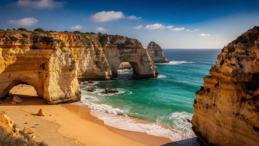
The Carvoeiro area has the best cliff-edge scenery on the central Algarve – the Algar Seco boardwalk is a concrete path bolted to the cliff face above a wave-carved grotto, and the Seven Hanging Valleys trail (Percurso dos Sete Vales Suspensos) runs 5.7 km along the clifftop from Carvoeiro to Benagil, passing the famous Benagil cave (accessible by kayak or boat from the beach below).
Lagos has a beautiful walled old town dating from the Moorish period, a vibrant restaurant scene, and Ponta da Piedade – a cluster of limestone rock arches and sea stacks 2 km south of town, reached by a short walk or by boat. The views from the clifftop path at Ponta da Piedade are among the most photographed in Portugal, and justifiably so.
West of Lagos, the coast becomes wilder and less developed. Sagres, at the southwestern tip of continental Europe, has a fortress perched on a windswept headland and surf beaches (Praia do Martinhal, Praia do Beliche) that attract year-round riders. Cape Saint Vincent (Cabo de Sao Vicente), 5 km further north, is the actual end-of-the-world point – a lighthouse on 75-meter cliffs where the sun sets over the Atlantic and where, in the 15th century, Henry the Navigator reportedly maintained a school of navigation.
Stops and distances from Faro:
| Stop | Distance from Faro | Highlights | Time Needed |
|---|---|---|---|
| Albufeira Old Town | 35 km | Tunnel beach, nightlife strip | 30-60 min |
| Carvoeiro + Algar Seco | 65 km | Boardwalk, rock formations | 1-1.5 hours |
| Benagil cave boat trip | 70 km | Sea cave, famous from above | 1 hour (from beach) |
| Seven Hanging Valleys trail | 65-70 km | Clifftop walk, 5.7 km one way | 2-3 hours (walk) |
| Lagos Old Town | 85 km | Slave market memorial, Moorish walls | 1-2 hours |
| Ponta da Piedade | 87 km | Rock arches, sea stacks | 45-60 min |
| Sagres Fortress | 115 km | Windward headland, history | 30-45 min |
| Cape Saint Vincent | 120 km | End of Europe, lighthouse | 30 min |
Road conditions: The N125 is a well-maintained two-lane road. Traffic is heavy in summer between Albufeira and Lagos (add 30-45 minutes). The A22 motorway runs parallel for the full route and is faster but uses electronic-only tolls (Via Verde transponder required). Consider the A22 for the less interesting eastern section and the N125 for Carvoeiro westward.
Beach access note: The most famous Algarve beaches (Praia da Marinha, Benagil, Praia do Camilo in Lagos) have very limited parking that fills by 10 AM in July-August. Either arrive before 9 AM or park in the nearest town and walk down to the beach via marked paths.
Route 2: Lisbon to Porto via Alentejo and Douro
| Distance: 650 km | Time: 3-4 days | Difficulty: Easy |
This is the classic Portugal road trip – the scenic route from the capital to the country’s second city, avoiding the A1 motorway in favor of the interior. The Alentejo region south of the Tagus river is one of Portugal’s hidden treasures: rolling cork oak forests, golden wheat fields, white-washed towns on hilltops, and a pace of life that is several decades behind Lisbon. The pace slows here, and that is entirely the point.
Day 1: Lisbon to Evora (135 km, 1.5 hours)
Cross the Tagus on the Vasco da Gama bridge (Europe’s longest bridge at 17.2 km, including the approaches) and head southeast into the Alentejo on the A6. At Montemor-o-Novo, consider dropping onto the N4 or N114 for the old road approach.
Evora is a UNESCO World Heritage city with 2,000 years of layered history. The Temple of Diana (actually dedicated to the Imperial cult, but the name has stuck for centuries) stands on the highest point of the old town, surrounded by ruins that somehow coexist comfortably with a modern city around them. The Se (cathedral) and its cloister are worth an hour. The Chapel of Bones (Igreja de Sao Francisco’s ossuary, decorated with the skulls and bones of over 5,000 monks) is the most visited and discussed attraction – simultaneously beautiful and profoundly unsettling.
Evora’s restaurant scene punches well above its size. Alentejo cooking – hearty, pork-forward, built around bread soups and coriander – is properly represented. We ate a carne de porco à alentejana (pork with clams) that we still think about.
Day 2: Evora to Monsaraz and Marvao (200 km, 3.5 hours)
Drive east to Monsaraz, a tiny fortified village perched on a ridge above the Alqueva reservoir (Europe’s largest artificial lake, 83 km long). The village is so small that the main street runs the full length in three minutes of leisurely walking – but the views from the castle walls stretch across the reservoir and into Spain. Sunsets here are worth staying for.
Continue north to Marvao, another hilltop fortress town near the Spanish border at 862 meters elevation. The 13th-century castle stands at the very highest point, and the views from the battlements on a clear day extend to Badajoz, Evora, and the Serra da Estrela. The drive through the Alentejo countryside – cork oaks being stripped of bark in distinctive patterns, olive groves, rolling grassland turning from green to gold with the seasons – is as good as the destinations.
Day 3: Marvao to Douro Valley (280 km, 3.5 hours)
Head north through Castelo Branco and toward the Serra da Estrela, Portugal’s highest mountain range (Torre summit at 1,993 meters). The IP2/A23 route passes through Covilha, the gateway to the mountains, where the ski resort operates December-March. Even without snow, the drive through the Serra offers views across both sides of the range.
The descent from the northern side of the Serra into the Douro watershed is dramatic – the landscape shifts from dry, open plateau to deep-cut river valleys with terraced vineyards. The Douro Valley appears suddenly, exactly as it should: a ribbon of river at the bottom of a deep gorge, with vineyard terraces climbing both sides at improbable angles.
Day 4: Douro Valley to Porto (120 km, 2 hours)
Follow the Douro River downstream to Porto, stopping at quintas (wine estates) for tastings and at viewpoints for the panoramas. The N222 river road has been repeatedly voted one of the world’s best driving roads by automotive publications – an assessment we would not argue with. The road hugs the valley wall above the river for much of its length, with view angles that change every kilometer as the river bends.
Pinhao is the valley’s hub – a small town with a train station decorated with 1930s azulejo tile panels depicting wine-making and harvesting scenes. From here, Quinta do Crasto, Quinta do Portal, and many others offer tastings and cellar tours. The drive from Pinhao to Peso da Regua at sunset is a photographic set piece.
Porto itself is a full-day exploration. The Ribeira waterfront, the port wine cellars of Vila Nova de Gaia (accessible via the lower deck of the Dom Luis I bridge), the Sao Bento train station with its azulejo panels, and the Livraria Lello (the bookshop that inspired Harry Potter, now impossibly crowded but still beautiful) are the main attractions. The francesinha – Porto’s answer to the croque monsieur, stuffed with cured meats and bathed in a spiced tomato-beer sauce – is the mandatory culinary experience.
| Day | Route | Km | Notable Stops |
|---|---|---|---|
| 1 | Lisbon → Evora | 135 | Vasco da Gama bridge, Evora temple, Chapel of Bones |
| 2 | Evora → Monsaraz → Marvao | 200 | Alqueva reservoir views, Marvao castle |
| 3 | Marvao → Serra da Estrela → Douro Valley | 280 | Serra summit, vineyard descent |
| 4 | Douro Valley → Pinhao → Porto | 120 | N222 wine road, port tasting, Porto Ribeira |
Route 3: Silver Coast (Lisbon to Nazare)
| Distance: 130 km | Time: 2 hours (without stops) | Difficulty: Easy |
The Silver Coast (Costa de Prata) north of Lisbon gets overshadowed by the Algarve, which suits it perfectly. The beaches are wilder, the surf is bigger, the towns are less touristy, and the driving is a pleasure on quiet roads through pine forests and dune-backed beaches. We drove this route in October and found virtually empty beaches and coastal restaurants still serving excellent grilled fish at prices the Algarve abandoned in 1985.
The route: Leave Lisbon heading north on the A8 motorway. At Torres Vedras, you have a decision: stay on the A8 for speed, or drop onto the N247 coastal road for atmosphere. We recommend the N247 from Peniche northward – it is the Silver Coast’s best driving road.
Obidos (85 km from Lisbon, signed from the A8) is a storybook medieval town enclosed by 14th-century walls. The entire old town is pedestrianized and small enough to walk end-to-end in 20 minutes. The main street (Rua Direita) is lined with whitewashed houses decorated with blue and yellow azulejo tiles and flower boxes. Buy a cup of ginjinha (cherry liqueur) served in a chocolate cup from one of the shops on the main street – the chocolate is thin enough to melt in your hands but holds the liqueur without leaking, which is exactly the level of engineering sophistication that Obidos deserves.
Peniche (95 km from Lisbon) is a working fishing port on a peninsula that is also one of Portugal’s premier surf spots. The Supertubos break at nearby Baleal hosts World Surf League tour events and has made Peniche famous in the surfing world. The Peniche fortress (Fortaleza de Peniche), built in the 16th century, was used as a political prison during the Salazar dictatorship and now houses an excellent museum. From the harbor, boats run to the Berlengas Islands – a nature reserve 12 km offshore with turquoise water, a 17th-century fort, and diving conditions that draw visitors from across Europe.
Nazare (130 km from Lisbon) is famous for two things: the massive waves at Praia do Norte, where tow-in surfers have ridden the largest waves ever recorded (Rodrigo Koxa set the world record here in 2017 at approximately 24.4 meters), and the traditional fishing culture of the Praia neighborhood, where women still sometimes wear the traditional seven-petticoat costume. The lighthouse at Forte de Sao Miguel Arcanjo – reachable by funicular or by climbing the cliff path – has a viewing platform for watching both the waves in winter and the village in all seasons.
Best stops from Lisbon:
| Stop | Distance | Highlights | Time Needed |
|---|---|---|---|
| Obidos | 85 km | Medieval walls, ginjinha, market | 1-2 hours |
| Peniche fortress | 95 km | History museum, harbor views | 30-45 min |
| Berlengas boat trip | 95 km (+ boat) | Island reserve, crystal water, fort | Half day |
| Sao Martinho do Porto | 120 km | Natural lagoon bay, swimming | 30-60 min |
| Nazare lighthouse viewpoint | 130 km | Wave watching (Oct-Apr), village view | 45-60 min |
Route 4: Douro Valley Wine Road
| Distance: 200 km loop from Porto | Time: Full day | Difficulty: Easy to moderate |
The Douro Valley is Portugal’s greatest gift to the road tripper. The river has carved a deep valley through the schist hills, and every available surface has been terraced for grape cultivation over more than 2,000 years. The resulting landscape – vineyard stairways climbing the valley sides, the river snaking below, white-walled quintas dotting the hillsides – is UNESCO-listed and genuinely stunning.
The route: Leave Porto heading east on the A4 to Amarante (60 km, 45 minutes), a charming Baroque town on the Tamega River with a photogenic bridge and São Gonçalo monastery, both reflected in the green water below.
Continue east on the A4 to the Douro River junction at Peso da Regua, picking up the N222 southward along the river. The N222 is the star – it follows the south bank of the Douro from Regua to Pinhao (25 km) through the heart of the Port wine region. The terraced vineyards rise on both sides, the river reflects the sky, and every viewpoint produces images that look implausibly photogenic.
Pinhao is the valley’s hub and the best base for winery visits. The Ramos Pinto, Quinta do Crasto, Quinta do Portal, and Quinta da Pacheca are among those offering tastings and cellar tours – most require advance booking but are well worth the effort. The azulejo tile panels at Pinhao’s train station (depicting port wine production and harvesting scenes) are a photography stop even if you are not taking the train.
Continue east on the N222 or N322 to Sao Joao da Pesqueira, a hilltop village above the valley with a viewpoint (Poco da Cruz) that provides the best aerial perspective on the terraced vineyards. The view is best in September-October when the vines turn from green to red and gold.
Return to Porto via the northern bank (IP2/N108), which provides different valley perspectives.
Wine estates along the route:
| Quinta | Location | Specialty | Booking Required |
|---|---|---|---|
| Quinta do Crasto | Near Regua | Full-bodied reds, port | Recommended |
| Quinta do Portal | Celeiros | Contemporary wines | Recommended |
| Quinta da Pacheca | Lamego area | Barrel-aging stays | Required for accommodation |
| Ramos Pinto | Pinhao | Port, tawny | Recommended |
| Quinta de la Rosa | Pinhao | Dry wines + port | Drop-in welcome |
Road conditions: The N222 is a well-maintained two-lane road that hugs the valley contours with curves, elevation changes, and occasional tunnels. It demands attention but rewards it spectacularly. Speed is naturally kept low by the road geometry – this is not a place to hurry. Not recommended for drivers uncomfortable with mountain-style roads without the mountain altitude.
Route 5: Madeira Mountain Circuit
| Distance: 150 km | Time: Full day | Difficulty: Challenging |
Madeira is the road trip for people who found the Algarve too easy. The island rises from the Atlantic to nearly 1,900 meters, and the roads negotiate that altitude change with a determination that produces more hairpin turns per kilometer than almost anywhere in Europe. There are also 200+ tunnels, some single-lane, some unlit, and all requiring headlights and confidence. We drove Madeira’s north coast road on a foggy morning and genuinely could not see the road 20 meters ahead in places. On a clear day, the same road delivers views that make you stop and get out just to confirm the Atlantic is really 400 meters below.
The route: Start in Funchal on the south coast. Drive west on the ER101 coastal road to Ribeira Brava (30 km, 45 minutes on the via rapida, faster through the tunnel), then turn north on the ER104, climbing into the mountains toward Encumeada pass (1,007 meters). This section is the climb – the road switchbacks through laurel forest and eucalyptus groves with views that alternate between the north and south coasts as the passes shift.
From Encumeada, continue north to Sao Vicente on the north coast, then east along the old coastal road (ER101) toward Santana and Porto da Cruz. This section is the most dramatic part of the circuit – the road clings to cliff faces, passes through narrow hand-cut tunnels (some requiring you to fold mirrors), and offers views of sheer drops to the Atlantic surf below. One section near Boaventura has the road cut directly into a basalt cliff face with no barrier between asphalt and the sea.
Return to Funchal over the mountains via Poiso pass (1,412 meters), stopping at the Pico do Arieiro viewpoint (1,818 meters) for views above the clouds on clear days. In the morning, the cloud layer often sits at around 1,200-1,400 meters – drive up from Funchal through grey murk, emerge above the clouds, and find yourself looking at mountain peaks rising through a white sea in brilliant sunshine while the coast is invisible below.
Best stops:
| Stop | Distance from Funchal | Highlights | Notes |
|---|---|---|---|
| Cabo Girao skywalk | 15 km west | Glass floor, 580m above sea | 30 min stop |
| Encumeada pass | 40 km | Mountain views, laurel forest | 20 min |
| Sao Vicente lava tubes | 50 km | Volcanic cave system, 30 min tour | Book in advance |
| Santana A-frame houses | 75 km | Traditional thatched houses, village | 30-45 min |
| Porto da Cruz | 85 km | Dramatic cliff coast, small beach | 30 min |
| Pico do Arieiro | 30 km from Funchal | Views above clouds, highest peak | 30-60 min |
| Monte tropical gardens | 5 km from Funchal | Botanical garden, monte ride | 1-2 hours |
Madeira-specific driving notes:
The via rapida (main motorway) is straightforward – modern, wide, and tunnel-heavy. The challenge is the estradas regionais. Key rules for surviving them comfortably:
Tunnels: Many are single-lane with traffic lights at each end. Wait for green before entering. Headlights mandatory. Some tunnels are several kilometers long and have no passing points – you cannot turn around if oncoming traffic enters.
Passing width: Some roads are two-lane in name and one-lane in practice. When two cars meet, one reverses to the nearest passing point. The car going uphill generally has priority (downhill reversing is easier), but in practice it is a negotiation. Drive slowly enough on mountain roads that you can stop and reverse without drama.
Levadas: Irrigation channels (levadas) run along the mountainsides, often with walking paths alongside them. Levada walks are Madeira’s most popular activity. You will encounter hikers on road sections near levada access points – treat them as pedestrians with attitude who believe they own the road (they are mostly correct).
Car size: We cannot overstate this – rent the smallest car available. A Fiat Panda, Renault Twingo, or VW Up handles Madeira’s narrow roads far better than a mid-size. The mountain roads have sections where two small cars can barely pass. Funchal’s street parking spots are sized for European superminis. We rented a VW Golf once and regretted it within 20 minutes of leaving the airport.
Planning Tips
Toll strategy: Get a Via Verde device from the rental agency for mainland trips. The EUR 1.50-2.50 per day pays for itself in convenience and peace of mind. See our driving guide for the full toll explanation. Madeira has no tolls.
N-roads vs. A-roads: Use motorways for long intercity transfers. Use national roads for scenic driving. The time difference between the A2 and the N2 for Lisbon-Algarve is about 1.5-2 hours over three days of driving – completely worth it for the scenery.
Fuel stops: Supermarket stations (Continente, Pingo Doce, Intermarche) are the cheapest. Fill up before entering motorways where prices are 10-15% higher.
Madeira car choice: Rent the smallest car available. A Fiat Panda or similar handles the mountain roads better than a mid-size. Funchal parking requires precision that larger cars cannot deliver in the tighter spots.
Booking ahead: Pre-book everything for July-August. Faro airport rentals in summer can run out; Funchal rentals for Easter and carnival are limited. Spring and autumn offer excellent road conditions without the pre-booking urgency.
For road rules and tolls, see our Portugal driving guide. Budget your trip with our costs guide. For airport pickup specifics, see our airport rental guide. Spain is the natural extension for multi-country road trips across the Iberian Peninsula.