Best Road Trips in Greece
We once spent three weeks driving through Greece with a vague plan and a paper map. The vague plan lasted about two days before the country started making its own suggestions – a hand-painted sign pointing to a beach we had never heard of, a local in a taverna insisting we drive “the old road” through the mountains, a ferry schedule that sent us to an island we had not planned to visit. Every detour was better than the plan it replaced. Greece rewards the driver who stays flexible.
The country’s geography practically demands a road trip. The mainland is a jagged mix of mountain ranges and coastal plains, the Peloponnese dangles like a hand reaching into the sea with fingers of peninsulas, and the islands range from Crete (big enough to need a week of driving) to specks of rock with a single paved road. Here are the routes that left the deepest impression.
Route 1: The Peloponnese Grand Loop (850 km, 7-10 days)
This is, in our opinion, the single best road trip in Greece. The Peloponnese has everything – ancient ruins, mountain villages, coastal drives, empty beaches – and almost no international tourists once you leave Nafplio and Olympia.
Itinerary:
Corinth Canal (stop for photos) – Nafplio (2 nights) – Epidaurus – Leonidio – Monemvasia (1-2 nights) – Gytheio – Mani Peninsula (1-2 nights) – Kalamata – Pylos – Olympia (1 night) – Dimitsana and Stemnitsa – back to Corinth
Highlights by section:
The drive from Nafplio south along the coast to Leonidio is spectacular – the road clings to cliffs above turquoise water, passes through tunnels cut into the rock, and drops into hidden coves. Budget two hours for what should be a one-hour drive, because you will stop constantly. The village of Paralio Astros has a fortress on a headland and a beach below it that combines both in a single view. Leonidio itself is a deep-red rock canyon village that most tourists skip entirely, which is their loss.
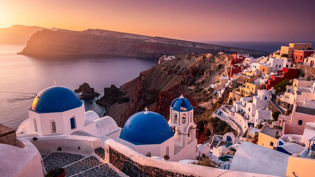
Monemvasia deserves its own paragraph. This medieval fortress town sits on a rock island connected to the mainland by a single causeway. No cars inside the walls – park in the lot on the mainland side and walk in. Stay overnight to see it after the day-trippers leave. At dusk, with the lights flickering on in the old Byzantine churches and the Laconic Gulf going pink, you will understand why people come here and refuse to leave.
The Mani Peninsula, the middle finger of the Peloponnese (and locals will tell you this is geographically and metaphorically accurate), has stone tower villages, wild coastline, and roads that range from good asphalt to goat tracks. The Diros Caves near Gytheio are worth the stop – you tour them by boat through underground lakes of stalactites and stalagmites, which is exactly as extraordinary as it sounds. Areopolos, the main town of the Deep Mani, has excellent local honey, dried figs, and a small square perfect for doing absolutely nothing for an hour.
The mountain road from Kalamata up to Dimitsana through the Lousios Gorge is one of the most beautiful drives in all of Greece. Monasteries hang from cliff faces, the river cuts through a deep valley below, and the villages of Stemnitsa and Dimitsana are frozen in a different century. Dimitsana has a museum of Greek liberation-era printing and pharmacy that is surprisingly absorbing. The road from Dimitsana north to Tripoli and then to Corinth is straightforward motorway and national road.
Practical details:
| Section | Distance | Driving Time | Road Quality |
|---|---|---|---|
| Corinth to Nafplio | 65 km | 1 hour | Motorway + good regional |
| Nafplio to Leonidio | 100 km | 2 hours | Coastal, narrow sections |
| Leonidio to Monemvasia | 80 km | 1.5 hours | Regional, good condition |
| Monemvasia to Gytheio | 95 km | 1.5 hours | Good regional |
| Gytheio to Kalamata (via Mani) | 120 km | 3 hours | Narrow, winding |
| Kalamata to Pylos | 65 km | 1 hour | Good coastal road |
| Pylos to Olympia | 100 km | 1.5 hours | Good regional |
| Olympia to Dimitsana | 80 km | 1.5 hours | Mountain, excellent views |
| Dimitsana to Corinth | 200 km | 2.5 hours | Motorway |
Best season: April-June or September-October. Summer is hot in the interior – the Mani in August can hit 40 C and has almost no shade.
Where to stay: Nafplio (boutique hotels in the old town, EUR 60-120 per night), Monemvasia (guesthouses inside the rock, EUR 80-150 per night), Areopolis (simple guesthouses, EUR 40-70 per night), Kalamata (hotels along the seafront, EUR 50-90 per night).
Peloponnese Extension: Olympia and Ancient Corinth
If your schedule allows, extend the loop to include Ancient Corinth (the ruins are excellent and less crowded than Delphi) and the beach town of Korinthia, which is an underrated overnight stop. The temple of Poseidon at Cape Sounion is technically in Attica, not the Peloponnese, but if you are starting or ending in Athens, the coastal drive south from Athens to the cape (70 km, about 1.5 hours) is one of the best sunset drives near the capital.
Route 2: Crete West to East (320 km, 5-7 days)
Crete is less a Greek island and more a small country. Driving its length from Chania in the west to Sitia in the east takes you through gorges, mountain plateaus, palm-lined beaches, and Minoan ruins. This is the island where you genuinely need a car – public transport along the south coast exists in theory and almost nowhere in practice.
Itinerary:
Chania (1-2 nights) – Balos Beach – Samaria Gorge area – Rethymno (1 night) – Heraklion and Knossos (1 night) – Lasithi Plateau – Agios Nikolaos (1 night) – Sitia – Vai Palm Beach
Highlights by section:
The road to Balos Beach from Kissamos is 12 km of unpaved switchbacks down to a parking area, followed by a 20-minute walk to what might be the most photogenic beach in Greece. The road is rough but passable in a regular car if you drive slowly. We saw a Smart car do it, so your rental Hyundai will be fine. Alternatively, take the boat from Kissamos – it skips the road entirely and arrives at the beach from the water, which is an excellent approach. The lagoon at Balos has water ranging from deep blue to turquoise to near-white in the shallows, and the views from the ridge above are extraordinary.
The national road along Crete’s north coast (E75) is a proper highway with sea views. The south coast, by contrast, has narrow mountain roads that take three times longer but deliver ten times the scenery. The road from Chora Sfakion to Frangokastello along the south coast is our favorite short drive on the island – 15 km of near-empty coastal road with a Venetian fortress appearing suddenly around a corner. Frangokastello has excellent tavernas on the beach, and the area is famous for the “Drosoulites,” an optical phenomenon where phantom soldiers appear in the morning mist in June. We did not see them, but we tried.
The Lasithi Plateau, a flat agricultural plain surrounded by mountains at 850 meters elevation, feels like arriving in a different country. Traditional (and mostly defunct) windmills, small farms, and the Dikteon Cave where Zeus was allegedly born. The cave is genuinely impressive – stalactites, stalagmites, and an underground lake – though the path down involves significant steps. Psichro village has restaurants with views of the plateau that are worth a long lunch.
From Agios Nikolaos, the road east to Sitia passes through increasingly wild and dramatic landscape. The Toplou Monastery is one of the finest in Crete and has a remarkable collection of Byzantine icons. Vai has Europe’s largest natural palm forest and a beach that is extremely popular in summer – arrive by 8 AM or accept crowds. Sitia itself is a relaxed port town that has managed to resist tourist development more successfully than most of Crete, with a long esplanade, good seafood, and almost no English-language menus.
Practical details:
| Section | Distance | Driving Time | Road Quality |
|---|---|---|---|
| Chania to Balos Beach | 55 km | 1.5 hours | Last 12 km unpaved |
| Chania to Rethymno | 60 km | 1 hour | Highway |
| Rethymno to Heraklion | 80 km | 1 hour | Highway |
| Heraklion to Lasithi | 55 km | 1.5 hours | Mountain road |
| Heraklion to Agios Nikolaos | 65 km | 1 hour | Highway |
| Agios Nikolaos to Sitia | 75 km | 1.5 hours | Coastal, good condition |
| Sitia to Vai | 25 km | 30 minutes | Good regional |
Best season: May-June or September-October. Avoid July-August unless you enjoy sharing the road with ten thousand other rental cars and competing for parking at every beach.
South coast detour: From Heraklion, heading south to Matala (the hippie cave-beach made famous in the 1960s, and still atmospheric) takes about 1.5 hours on mountain roads. From Matala, the coastal drive west to Agia Galini and then to Plakias is a full day’s driving on spectacular but narrow roads. Worth every meter.
Route 3: Meteora and Northern Greece (500 km, 4-5 days)
Northern Greece is the part most tourists skip entirely, and that is precisely why you should go. The drive from Thessaloniki through the Meteora monasteries to the Zagori villages in Epirus is Greece at its most dramatic and least crowded.
Itinerary:
Thessaloniki (1 night) – Vergina – Meteora/Kalambaka (2 nights) – Metsovo – Ioannina (1 night) – Zagori villages and Vikos Gorge – back to Ioannina or continue to Igoumenitsa for ferry
Highlights by section:
Meteora needs no introduction, but seeing those monasteries perched on sandstone pillars while driving up the valley road genuinely takes your breath away every single time. Visit early morning or late afternoon when the tour buses are gone. The sunrise from the Great Meteoron Monastery viewing area, with fog filling the valley below the rocks, is one of the most extraordinary sights in Greece. The sunset from the observation point near the Grand Meteoron monastery is worth organizing your entire day around. Six of the original twenty-four monasteries are still active and open to visitors (modest dress required – they provide wraps at the entrance, but the clothing check can add delay in busy periods).
The drive from Kalambaka to Metsovo crosses the Pindus mountain range via the Katara Pass at 1,705 meters. The road is modern (part of the E92), but the views into deep valleys are extraordinary and the Katara Pass itself, at the top, offers views of the Pindus range in both directions on clear days. Metsovo itself is a stone-built mountain town that feels more Alpine than Mediterranean, with excellent cheese (metsovone, a smoked semi-hard cheese that is one of the best in Greece), wine from the Katogi-Averoff winery, and a folk museum in a 19th-century mansion that is genuinely interesting.
The Zagori region contains 46 traditional stone villages, the Vikos Gorge (one of the deepest gorges relative to its width in the world, recognized by the Guinness Book of Records), and some of the best hiking in Greece. Drive to Monodendri for the gorge viewpoint – the view down into the gorge from the monastery at the edge of the village is vertiginous. Cross the ancient Plakidas stone bridge (it was probably not ancient when built, but it looks ancient and that is close enough). If you have time, drive down to the Voidomatis River springs – the water is absurdly clear, ice-cold even in summer, and that particular shade of turquoise that makes you wonder if you are looking at a photograph.
Practical details:
| Section | Distance | Driving Time | Road Quality |
|---|---|---|---|
| Thessaloniki to Vergina | 80 km | 1 hour | Motorway |
| Vergina to Kalambaka | 170 km | 2.5 hours | Mix of motorway and regional |
| Kalambaka to Metsovo | 60 km | 1 hour | Mountain highway |
| Metsovo to Ioannina | 55 km | 1 hour | Good mountain road |
| Ioannina to Zagori | 35 km | 45 minutes | Narrow mountain roads |
| Zagori villages circuit | 60 km | 2 hours | Narrow, unpaved sections possible |
Best season: May-October. The Zagori villages are magical in autumn with changing foliage (October especially). Winter brings snow to the Pindus passes; the Katara Pass occasionally closes after heavy snowfall. Spring (May) brings the rivers in the gorge to full dramatic flow.
Vergina detour: The royal tombs at Vergina (ancient Aegae) are one of the most extraordinary archaeological sites in Greece and severely under-visited compared to Athens. The burial mounds hold the intact tombs of Philip II of Macedon (Alexander the Great’s father) with grave goods that include golden larnax, armor, and ivory portraits. Budget half a day.
Route 4: Athens to Delphi and the Gulf of Corinth (350 km, 3-4 days)
A shorter route that packs ancient history and coastal scenery into a long weekend. Perfect if you have limited time or want to combine with a Peloponnese extension.
Itinerary:
Athens – Delphi (1-2 nights) – Nafpaktos – cross Rio-Antirrio Bridge – Patras – coastal road back to Athens or continue to the Peloponnese
Highlights by section:
The drive from Athens to Delphi (180 km, about 2.5 hours) takes you through the Boeotian plain and up into the mountains above Arachova, a charming ski-town-turned-year-round-destination with good restaurants and exceptional local honey. Arachova is worth a stop even without visiting Delphi – the village above the gorge is genuinely pretty and has the best souvlaki we have found in central Greece. Delphi itself, perched on the side of Mount Parnassus overlooking a valley of olive trees stretching to the sea, is the most dramatically situated ancient site in Greece. Arrive at opening time (8 AM) to have the Temple of Apollo and the stadium nearly to yourself. The Delphi Archaeological Museum has the famous bronze Charioteer, one of the finest bronzes from antiquity, and the museum alone justifies the visit.
From Delphi, the road west along the north shore of the Gulf of Corinth passes through Galaxidi (a pretty harbor town worth a lunch stop – the Barko restaurant on the waterfront has good grilled fish and a view that makes you want to stay the rest of the day) and Nafpaktos (a Venetian fortress town with a beach inside the harbor walls – one of the more unusual beach setups we have encountered). Cross the Rio-Antirrio Bridge (EUR 13.90 toll) for a five-minute drive over one of the longest cable-stayed bridges in the world. The structure is impressive regardless of how many bridges you have seen.
Practical details:
| Section | Distance | Driving Time | Road Quality |
|---|---|---|---|
| Athens to Delphi | 180 km | 2.5 hours | Motorway + mountain road |
| Delphi to Nafpaktos | 100 km | 1.5 hours | Good coastal/mountain |
| Nafpaktos to Patras (via bridge) | 15 km | 20 minutes | Bridge + motorway |
| Patras to Athens | 210 km | 2 hours | Motorway |
Best season: Year-round. Delphi in winter with snow on Parnassus is hauntingly beautiful. Spring brings wildflowers to the slopes below the ruins. Summer is hot but the site is manageable if you start early.
Route 5: The Epirus Coast and Ionian Islands Gateway (400 km, 4-5 days)
This route is less well-known among foreign visitors and is all the better for it. Epirus and the Ionian Coast combine dramatic mountain driving with some of the most beautiful coastal scenery in western Greece.
Itinerary:
Ioannina (1 night) – Ali Pasha’s island – Parga (1 night) – Preveza – Lefkada (2 nights, drive there via the swing bridge) – back to Preveza or fly from Aktion airport
Highlights by section:
Ioannina, the capital of Epirus, sits on the shore of Lake Pamvotis with a fortress island in the middle. A short boat crossing reaches the island where Ali Pasha (the Ottoman governor who defied Napoleon and eventually the Sultan) was assassinated in 1822. The fortress monastery where this happened is visited by tourists who receive very little context for what they are seeing, which is a shame – the history is extraordinary. The city’s old bazaar district around the main square has excellent silverwork (Ioannina is Greece’s silversmithing capital) and very good restaurants.
The drive from Ioannina southwest to Parga follows mountain roads that descend toward the coast through increasingly dramatic scenery. Parga is a postcard-perfect town with a Venetian castle above, a beach below, and a small island with a chapel in the bay. It is popular with Greek tourists and relatively unknown to international visitors. Accommodation is reasonably priced, the food is good, and the general atmosphere is exactly what a Greek coastal town should be.
Lefkada is connected to the mainland by a swing bridge – the only Ionian island you can reach without a ferry. The road onto the island crosses the bridge and immediately enters a long causeway with the lagoon on one side and the sea on the other. The island has some of the finest beaches in Greece: Porto Katsiki and Egremni on the west coast are genuinely world-class, with white cliffs and water color that is not quite blue and not quite green. The road to Porto Katsiki descends steeply through 100 meters of hairpins – doable in a regular car, unforgettable in a small city car.
Practical details:
| Section | Distance | Driving Time | Road Quality |
|---|---|---|---|
| Ioannina to Parga | 90 km | 1.5 hours | Mountain, good condition |
| Parga to Preveza | 65 km | 1 hour | Coastal |
| Preveza to Lefkada (via bridge) | 30 km | 40 minutes | Flat, bridge crossing |
| Lefkada internal driving | 50 km | 1.5 hours | Variable, west coast steep |
Route Comparison Table
| Route | Distance | Duration | Difficulty | Best Season | Highlights |
|---|---|---|---|---|---|
| Peloponnese Grand Loop | 850 km | 7-10 days | Moderate | Apr-Jun, Sep-Oct | Monemvasia, Mani, ancient sites |
| Crete West to East | 320 km | 5-7 days | Easy-Moderate | May-Jun, Sep-Oct | Balos Beach, gorges, Knossos |
| Meteora & Northern Greece | 500 km | 4-5 days | Moderate | May-Oct | Meteora monasteries, Zagori, Vikos |
| Athens to Delphi Loop | 350 km | 3-4 days | Easy | Year-round | Delphi, Gulf of Corinth, bridge |
| Epirus & Ionian Coast | 400 km | 4-5 days | Moderate | May-Oct | Parga, Lefkada beaches, Ioannina |
Planning Your Road Trip
Which route for first-timers? The Peloponnese Grand Loop. It has the best mix of sights, manageable driving, and flexibility to shorten or extend. Start from Athens or Corinth, drive counter-clockwise, and adjust your pace based on how much you want to linger.
Combining routes: With three weeks, you can do the Peloponnese and Crete back-to-back. Drive the Peloponnese, drop the car at Kalamata or Athens, ferry to Crete (Heraklion or Chania), and rent a second car on the island. Some agencies allow one-way mainland-to-island rentals, but expect a hefty surcharge. Many people find it simpler to do one-way rental to the port, take the ferry as foot passengers, and rent fresh on the island.
Island driving: Beyond Crete, driving on smaller islands is worth it on Naxos, Rhodes, Kefalonia, Corfu, and Zakynthos. On tiny islands (Mykonos, Santorini), a car helps but is not essential – ATV or scooter rentals are popular alternatives, though the injury rate among tourist scooter renters gives us pause. On Naxos, renting a car to reach the mountain villages of the interior (Filoti, Apeiranthos) opens a completely different side of what most visitors think of as just a beach island.
Car ferries: You can take rental cars on most Greek ferry routes from Piraeus, but check with your rental agency first. Many agencies prohibit taking cars off the mainland or between islands. Companies like Avis and Hertz usually allow it with prior notice and an extra fee. Blue Star Ferries and ANEK Lines are the main operators for vehicle-carrying routes. The Athens-Heraklion overnight ferry (about 9 hours) is a classic – you drive on in Piraeus at 9 PM and wake up in Crete.
Navigation: Google Maps works well across Greece, including on islands. Offline maps are recommended for mountain areas where cell coverage drops. Waze is popular among locals and useful for real-time traffic in Athens. For detailed hiking and trail access on islands, Maps.me has better coverage than Google for unmaintained tracks.
For driving rules and license requirements, see our Greece driving guide. For practical tips on booking a rental, check our airport car rental guide. If you are considering Greece alongside other Mediterranean destinations, our Cyprus routes make a natural extension for an extended trip.