Driving in Iceland
We learned more about driving in Iceland during our first hour than we expected to learn in a week. Within 60 minutes of leaving Keflavik Airport, we had experienced sidewind so strong it pushed the car half a lane to the right, passed through a cloud of volcanic dust that reduced visibility to 20 meters, and crossed our first single-lane bridge while a campervan approached from the other direction. Then the clouds parted, a rainbow appeared over a lava field, and we understood why people come here. Iceland driving is not difficult, but it demands respect and preparation in ways that no other European country does.
Road Rules at a Glance
| Rule | Details |
|---|---|
| Driving side | Right |
| Minimum driving age | 17 (rental: 20-25 depending on vehicle) |
| Speed limit - urban | 50 km/h (sometimes 30 km/h) |
| Speed limit - gravel roads | 80 km/h |
| Speed limit - paved roads | 90 km/h |
| Blood alcohol limit | 0.05% |
| Headlights | Mandatory at all times, day and night |
| Seatbelts | Mandatory for all occupants |
| Mobile phone | Hands-free only |
| Child seats | Required for children under 150 cm |
| Off-road driving | Strictly prohibited, heavy fines |
| F-road access | 4x4 vehicles only |
The off-road driving ban deserves special emphasis. Driving off marked roads or tracks is illegal in Iceland and carries fines starting at 50,000 ISK (about EUR 340). Iceland’s fragile volcanic landscape takes decades to recover from tire tracks – in some cases, the marks persist for centuries. This is not a suggestion – it is actively enforced and socially unacceptable, and locals will photograph and report violations.
Driving License Requirements
EU and EEA licenses are accepted directly. Non-EU drivers should carry an International Driving Permit alongside their national license. In practice, most agencies will rent to holders of licenses from the US, Canada, UK, Australia, and most other countries without an IDP, but having one avoids potential complications at checkpoints.
Age requirements are stricter than in most countries:
| Vehicle Type | Minimum Age | Typical Surcharge |
|---|---|---|
| Economy/Compact (2WD) | 20-21 | EUR 5-10/day for under 25 |
| Mid-size/Full-size | 21-23 | EUR 5-10/day for under 25 |
| 4x4/SUV | 23-25 | None above minimum age |
| Campervan | 23-25 | Varies by agency |
These age minimums are real restrictions, not guidelines. Some agencies are even stricter for premium 4x4s (Toyota Land Cruiser-class), requiring 25+ with additional documentation.
Road Types and Conditions
Iceland’s roads fall into distinct categories, and understanding them is critical for choosing the right rental vehicle.
Route 1 (Ring Road): The main highway circling the island at approximately 1,322 km. Almost entirely paved (a few short gravel sections remain in the east, particularly east of Hofn). Two lanes, well-maintained, with clear markings and signage in both Icelandic and English. This road is the backbone of most Iceland road trips and is accessible with any rental car in summer. In winter, Route 1 can close temporarily in the north and east sections during severe storms.
Paved secondary roads (numbered routes): Many popular destinations are reached via paved secondary roads branching off Route 1. The road to Vik, the road to Husavik, the road to Akureyri – these are all standard paved roads in good condition. Some, particularly in the Westfjords, are narrower and more challenging than the Ring Road.
Gravel roads (numbered routes): Some secondary roads are unpaved. They vary from smooth and well-graded to rough and washboarded, depending on recent maintenance and traffic. A 2WD car can handle most gravel roads in dry conditions, but drive at 60-70 km/h maximum despite the posted 80 km/h limit to avoid stone chips on the windshield and undercarriage damage. The east road to Dettifoss (Route 864) is a notable gravel road, as are significant portions of the Westfjords road network.
F-roads (highland roads): Designated by an “F” prefix (F26, F35, F208, F210, etc.), these are unpaved highland tracks that cross rivers, volcanic deserts, and remote mountain passes. 4x4 vehicles only. Period. Driving an F-road in a 2WD car voids your insurance, violates your rental agreement, and risks getting stranded in a place where cell phone reception does not exist and rescue is measured in hours. F-roads are typically open from late June through September or early October, depending on snow depth and river levels.
River crossings (fords) on F-roads: Some F-roads require fording rivers without bridges. This is not a metaphor – you drive your car through flowing water of varying depth, typically 30-60 cm but occasionally deeper. This requires experience, a capable 4x4 with high clearance, and specific techniques: approach slowly to read the current, enter at an angle against the flow, stay in low gear, maintain steady momentum without stalling. If you have never done this before, do not start on Icelandic rivers where water levels can change within hours due to rain or glacial melt. The consequences of a stall mid-ford are expensive and potentially dangerous.
Key F-roads and What to Expect
| F-road | Destination | Difficulty | River Crossings | Season |
|---|---|---|---|---|
| F35 (Kjolur) | Hveravellir | Moderate | Few, usually fordable | Jul-Sep |
| F26 (Sprengisandur) | Cross-country highlands | Hard | Multiple, variable | Jul-Sep |
| F208 | Landmannalaugar | Moderate-Hard | Several | Late Jun-Sep |
| F225 | Landmannalaugar approach | Hard | Variable | Jul-Sep |
| F249 | Thorsmork | Hard | Several, can be deep | Jul-Sep |
| F210 (Fjallabak) | Landmannalaugar area | Hard | Multiple | Jul-Sep |
Speed Limits and Enforcement
| Zone | Speed Limit |
|---|---|
| Urban areas | 50 km/h (30 km/h in residential zones and school areas) |
| Gravel roads | 80 km/h (but drive slower in practice) |
| Paved rural roads | 90 km/h |
There is no higher speed limit – 90 km/h is the maximum on any road in Iceland, including Route 1. Iceland uses both fixed speed cameras and mobile radar units. Fines are steep:
| Offense | Fine |
|---|---|
| 10-15 km/h over | 10,000-20,000 ISK (EUR 65-135) |
| 16-25 km/h over | 25,000-50,000 ISK (EUR 170-340) |
| 26-40 km/h over | 70,000-100,000 ISK (EUR 475-680) |
| 41+ km/h over | 100,000+ ISK (EUR 680+), possible license suspension |
Speed cameras are concentrated on approaches to towns and along popular stretches of Route 1. The cameras are marked with warning signs, but mobile units operate without any advance warning. Rental agencies pass fines to your credit card with an administrative surcharge of 2,000-5,000 ISK (EUR 13-34).
Section Speed Cameras
Specific sections of Route 1 use section control (average speed measurement between two points), particularly near Selfoss and on the south coast. Driving fast and braking for the camera does not work here – the system measures your average speed over the entire section.
Fuel and Gas Stations
| Fuel Type | Price per Liter (2026) | Per Fill (50L tank) |
|---|---|---|
| Petrol (95 oktan) | 340-370 ISK | 17,000-18,500 ISK (EUR 115-125) |
| Diesel | 350-380 ISK | 17,500-19,000 ISK (EUR 118-130) |
Yes, those numbers are real. Filling a tank in Iceland costs roughly the same as a reasonable guesthouse room. Fuel is expensive, and there is no way around it. Budget EUR 120-180 in fuel for a full Ring Road trip in a 2WD car, more for a 4x4.
Station spacing is critical. On the Ring Road, fuel stations appear every 50-100 km in the south and west. In the north and east, gaps can stretch to 150-200 km. The longest gap on Route 1 is in the eastern fjords region (between Hofn and Berunes), where you should not pass a station without filling up if your tank is below half.
Most stations are automated self-service pumps accepting credit cards (Visa and Mastercard). The two main networks are N1 and Orkan/OB. Both accept international cards. Some pumps require a 4-digit PIN rather than chip-and-sign – contact your bank before the trip or carry a second card as backup.
On F-roads, there are no fuel stations. Fill up at the last station on Route 1 before entering the highlands and carry a fuel reserve if your F-road segment exceeds 200 km. Jerricans of fuel are available at some outdoor equipment shops in Reykjavik.
Fuel Station Spacing by Ring Road Section
| Section | Key Stations | Max Gap |
|---|---|---|
| Reykjavik to Selfoss | Multiple | 30-40 km |
| Selfoss to Vik | Hvolsvollur, Kirkjubaej | 70 km |
| Vik to Hofn | Kirkjubaej, Skaftafell, Hofn | 90 km |
| Hofn to Djupivogur | Hofn essential | 90 km |
| Djupivogur to Egilsstadir | Djupivogur, Breidalsvik | 80 km |
| Egilsstadir to Myvatn | Modruvellir | 100 km |
| Myvatn to Akureyri | Reykjahlid, Laugar | 70 km |
| Akureyri to Blonduos | Varmahlid | 100 km |
| Blonduos to Borgarnes | Bifrost area | 90 km |
Tolls and Road Fees
Iceland has essentially no toll system. The exceptions:
- Vatnaleidi Tunnel (Hvalfjardarleidi, Route 1 north of Reykjavik): 1,000 ISK (~EUR 7) for passenger cars. Automatic via license plate – billed to rental agency and charged to your card.
- Vadlaheidargong Tunnel (Hvalfjardarvegin, Akureyri to Husavik shortcut): 1,500 ISK (~EUR 10) one way. Pay online at tunnel.is before or after transit.
- Thingvellir National Park parking: 750 ISK (~EUR 5) per vehicle.
No vignettes, no road taxes, no city congestion charges. The total toll cost for a Ring Road trip is about EUR 12-17.
Parking
Parking in Reykjavik requires attention. The city center uses a zone system:
| Zone | Color | Hourly Rate |
|---|---|---|
| P1 | Red | 350 ISK (~EUR 2.40) |
| P2 | Blue | 200 ISK (~EUR 1.35) |
| P3 | Green | 125 ISK (~EUR 0.85) |
| P4 | Orange | Free with time limit |
Pay via the Parka app (recommended – works everywhere and sends payment confirmation), at parking meters, or by SMS. Enforcement is consistent and fines start at 5,000 ISK (EUR 34). The Parka app stores your plate number and allows payment remotely if you underestimate your stay.
Outside Reykjavik, parking is mostly free. Popular tourist sites (Gullfoss, Geysir, Skogafoss, Seljalandsfoss) have free parking lots. Thingvellir National Park charges the 750 ISK parking fee. The Jokulsarlon glacier lagoon parking lot is free. Most waterfall and viewpoint stops on Route 1 have free gravel lots.
Crowding at popular sites in summer: Major south coast stops (Seljalandsfoss, Reynisfjara) can see their parking lots fill completely by mid-morning in July and August. Arrive before 9 AM or after 7 PM to find space without the crowd.
Traffic Culture and Driving Style
Icelandic drivers are among the most considerate in Europe. They observe speed limits, use turn signals, and give way predictably. The only consistent issue is tourists driving slowly in the passing lane while photographing scenery through the windshield – do not be this person. Pull over safely to take photos; driving and photography are incompatible.
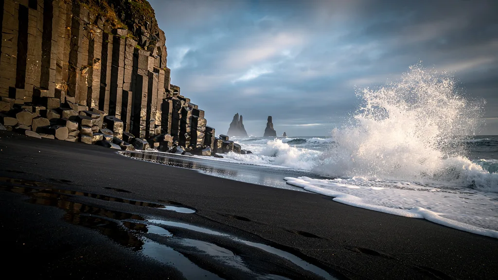
Single-lane bridges: These are a distinctive and charming feature of Icelandic driving, particularly on the south coast. Many bridges over rivers and ravines are one-lane only, often only wide enough for one vehicle with steep sides and no railings that would encourage mistakes. The rule is clear: the car that arrives first has right of way. If the other car is already on the bridge, wait at the pull-off before the entrance. If you arrive simultaneously with another car, the car closest to the bridge goes first. Flashing headlights can indicate “you go first” but interpretation varies. These bridges work on an honor system, and Icelanders are patient about them. Rushing onto a bridge when another car is approaching is both dangerous and spectacularly rude.
Sheep on the road: From June to September, Icelandic sheep roam freely across the countryside, including on and near roads. This is not a tourism gimmick – this is how Iceland manages its sheep population, and they have no more road sense than you would expect from a sheep. They are unpredictable: a sheep standing calmly on the roadside can bolt across your path without warning, often running toward other sheep that may be on the opposite side of the road. Slow down significantly when approaching any sheep. Lambs are particularly erratic.
Wind: This is a genuine driving hazard, not a minor inconvenience. Icelandic wind can reach 100+ km/h without warning, particularly in exposed areas like the Snaefellsnes Peninsula, the highland passes, the south coast between Vik and Hofn, and the East Fjords ridgelines. Car doors can be ripped from hinges by sudden gusts – this happens regularly enough that rental agencies include wind damage as a specific insurance category. Always hold your door firmly when opening it in any exposed area. Park facing into the wind when possible. High-profile vehicles (campervans, SUVs) are more dramatically affected by crosswinds on the road.
Important Driving Habits to Develop
- Check road.is every morning. Road conditions in Iceland change fast.
- Never drive through or around a road closure. Icelandic closures are for real reasons, usually involving conditions that can kill you.
- Do not attempt to photograph the landscape through the windshield while driving. Pull over. The scenery will still be extraordinary from a stopped vehicle.
- Stay on marked roads. Every year, tourists get stuck in boggy ground beside roads. The tire tracks leading there from previous tourists do not mean it is safe.
- Respect other drivers at single-lane bridges by waiting your turn and not crowding the entrance.
Navigation and Connectivity
road.is is the single most important website for driving in Iceland. It shows real-time road conditions, closures, and weather warnings for every road in the country, updated continuously. Check it every morning and before any long drive. The site has an English version and a mobile-friendly interface.
vedur.is is the Icelandic Meteorological Office website and provides detailed weather forecasts for specific roads and areas. Essential for planning driving days, particularly in spring and autumn when conditions are most variable.
safetravel.is allows you to register your travel plan before driving into remote areas. If something goes wrong, search and rescue (ICE-SAR) teams know where to look. Registration is free and takes 2 minutes.
Cell coverage: Good along Route 1 and in populated areas. Spotty to nonexistent in the highlands (all F-roads), the Westfjords interior, the remote East Fjords, and some highland passes on Route 1. Download offline maps (Google Maps or Maps.me) for the entire island before leaving the airport. If driving F-roads, strongly consider renting a satellite communicator or personal locator beacon.
Emergency Information
| Service | Number |
|---|---|
| General emergency | 112 |
| Road conditions | 1777 (Vegagerdin) |
| Weather | vedur.is |
| Road conditions website | road.is |
| Police (non-emergency) | 444 1000 |
| Search and rescue (ICE-SAR) | 112 |
In case of breakdown or accident in a remote area:
- Stay with the vehicle unless it is unsafe to do so
- Call 112 and provide your GPS coordinates (your phone will show these)
- Register at safetravel.is before driving remote areas – if you have not, at least tell someone your planned route
- Use your satellite communicator if cell coverage is unavailable
- Stay visible to aerial search – a reflective vest or bright jacket works as signaling
ICE-SAR (Iceland Search and Rescue) is a volunteer organization that responds to thousands of incidents per year, many involving tourists in rental cars who went off-road, attempted a ford that was too deep, or got stuck in highland terrain. Their service is free, but calling them out costs them time and resources. Do not drive beyond your vehicle’s or your own capabilities.
Seasonal Driving Considerations
Summer (June-August): The golden season. Near-24-hour daylight, all roads open (including most F-roads from late June), dry conditions, and temperatures of 10-15 C. You can visit Seljalandsfoss at midnight in June with full daylight. This is when most visitors come, and when rental prices peak. Book 8-12 weeks ahead for summer rentals.
Shoulder season (May and September): Variable conditions. Most of Route 1 is accessible, but F-roads may be closed, some mountain passes can have snow, and weather is less predictable. September offers northern lights potential (from around September 15 as days shorten) while retaining summer road access. Rental prices drop 20-30% from summer peaks. May is excellent value if you do not need highland access.
Autumn (October-November): Increasingly difficult conditions. First snow, ice on roads, short daylight hours (6-8 hours by November). Northern lights season in full swing. Winter tires become necessary from November 1 (mandatory). Only recommended for experienced winter drivers.
Winter (December-March): Short daylight (4-5 hours in December), frequent storms, ice and snow on all roads, potential Route 1 closures in the north and east. The south coast (Reykjavik to Vik) and Golden Circle are driveable in winter with studded tires and careful monitoring of road.is. The north and east can be closed for multiple days during storms – “stranded in Iceland” is a real scenario that happens to overconfident tourists every winter. Winter driving in Iceland requires experience, a capable 4x4, studded tires (mandatory and provided by agencies), and willingness to wait out storms.
Winter tires: Mandatory from November 1 to April 15. All rental cars during this period come equipped with studded winter tires. In shoulder months (October and late April), ask specifically about tire type.
Road Conditions Month by Month
| Month | Route 1 Status | F-Roads | Snaefellsnes | Westfjords |
|---|---|---|---|---|
| January | Open (weather closures possible) | All closed | Mostly paved, check conditions | Limited access |
| February | Open (closures in north) | All closed | Open with caution | Limited |
| March | Open | All closed | Open | Limited |
| April | Open | All closed | Open | Opening some routes |
| May | Open | Closed (some opening late May) | Open | Opening |
| June | Open | Opening (from mid-to-late June) | Fully open | Open |
| July | Open | Fully open (most) | Fully open | Fully open |
| August | Open | Fully open | Fully open | Fully open |
| September | Open | Closing (from late September) | Open, watch weather | Open |
| October | Open (north caution) | All closed | Open with caution | Limited |
| November | Closures possible in north | All closed | Check daily | Very limited |
| December | North and east closures possible | All closed | Check daily | Very limited |
F-road opening: The exact opening date for each F-road varies annually based on snowpack and river levels. The earliest common opening is late June for the most accessible routes (F35 Kjolur); the most demanding routes (F26 Sprengisandur) may not open until mid-July. Check safetravel.is and road.is for current F-road status.
Driving With a Campervan
Campervans are a popular alternative to a car plus accommodation, and they add specific driving considerations:
Height: Most campervans in Iceland are 2.5-3.0 meters high. This affects tunnel clearance (some older tunnels have reduced height sections) and crosswind behavior. At 100 km/h lateral winds of 60+ km/h, a campervan behaves very differently from a sedan. Reduce speed in exposed areas; slow to 60-70 km/h if the van is drifting.
Overnight parking: Camping in Iceland requires a designated campsite (Ferdalag or Camping Card program sites). Roadside camping outside designated areas became illegal in 2015 — the fine is substantial and enforcement has increased. Campground maps are available at Camping Card offices and online.
Campervan on F-roads: Standard campervans (2WD) are NOT permitted on F-roads. The weight, ground clearance, and river crossing implications make this inappropriate. 4x4 campervans exist and are specifically marketed for highland access — if this is your plan, confirm at booking that the vehicle is F-road rated and that your insurance covers F-road driving.
Single-Lane Bridge Protocol
Iceland’s single-lane bridges are the most consistently misunderstood feature of Icelandic driving for first-time visitors. The formal rule:
- The car that arrives first at the bridge has right of way and proceeds. The other car waits at the pull-off area.
- If two cars arrive simultaneously, the one closer to the bridge goes first. The other waves them through.
- Do not rush onto a bridge when another car is clearly approaching — they may already be committed and stopping mid-bridge creates a worse problem than yielding.
- High beams signal “you go first.” This is a courtesy gesture, not a rule, and interpretation varies. If someone flashes high beams at you, they are usually yielding. Proceed slowly to confirm this.
- Bridges in Iceland have no central barriers. Two cars cannot pass. One must wait.
The bridges are not frustrating once you understand the rhythm — they are an interesting social experiment in automotive courtesy. Iceland has them in large numbers, particularly on the south coast. You will use this protocol dozens of times on a Ring Road trip.
Navigation in Detail
road.is (English available) is the official Iceland road conditions website maintained by the public roads administration. It shows:
- Real-time closure status for all roads
- Road surface conditions (paved, gravel, ice)
- Weather-related alerts
- F-road open/closed status
Check it every morning. The information is accurate and updated continuously.
Google Maps in Iceland: Works reliably on Route 1 and all paved roads. Less reliable on gravel tracks and F-roads where routing may be incorrect or outdated. For F-roads, use Maps.me (downloaded offline) which has better track coverage.
Waze in Iceland: Not widely used — population density is too low for crowd-sourced traffic data to be meaningful. Stick to Google Maps.
Coordinates (GPS): Iceland uses the standard WGS84 coordinate system. If someone sends you GPS coordinates for a remote location, they work directly in Google Maps. Save coordinates for your intended overnight stops, fuel stations, and any remote destinations before entering areas without cell coverage.
Icelandic addresses: Iceland uses a unique system where farms and rural locations are identified by their local name rather than a street address. GPS navigation in rural areas often requires coordinates rather than addresses. Accommodation booking confirmations usually include coordinates for this reason.
Emergency Contact Reference Card
Before driving in Iceland, save these:
| Contact | Number / URL |
|---|---|
| Emergency (all services) | 112 |
| ICE-SAR (search and rescue) | 112 |
| Road conditions | road.is or call 1777 |
| Weather service | vedur.is |
| Safe travel registration | safetravel.is |
| Rental agency emergency | (save from rental agreement) |
| Tunnel payment (Vadlaheidargong) | tunnel.is |
safetravel.is registration: This takes 2 minutes and may be the most important thing you do before a remote drive. Register your: names of travelers, vehicle plate number, planned route, expected completion time, and emergency contact. If you do not check back in, ICE-SAR knows where to look.
Specific Driving Hazards by Season
Summer:
- Tourist volume: Heavy traffic on south coast; Seljalandsfoss parking lots can overflow by 10 AM in July
- Midnight sun: Fatigue from 24-hour daylight; you will want to drive at midnight because it is light — do it, but do not drive tired
- Sheep: June-September sheep are on all roads; lambs are the least predictable
Winter:
- Black ice: Invisible on road surfaces, particularly on bridges where air temperature drops faster than road temperature
- Whiteout conditions: Blowing snow can drop visibility to zero on exposed south coast stretches
- Variable conditions: A road that was clear at 9 AM may be drifting snow by noon after a weather shift
For route planning, head to our Iceland road trips guide. For pickup logistics, see the airport rental page. And for a full cost breakdown including the eye-watering fuel prices, check our costs and tips guide.