Best Road Trips in South Africa
South Africa is built for road trips. The distances are honest — you will not pretend to cover the whole country in a week — and the scenery transitions are so dramatic that every few hours feels like entering a different country. We drove from Cape Town to the Kruger area over ten days, and the landscape shifted from Mediterranean vineyards to coastal forests to semi-arid Karoo to subtropical savanna, with mountain passes, whale-watching spots, and roadside ostrich farms in between. The car odometer said 2,100 km. It felt like a journey around the world.
The country’s road network is excellent by African standards and perfectly adequate by global ones. The main N-roads are modern highways, the scenery is relentless, and the infrastructure (fuel, food, accommodation) along the major routes is solid. Self-drive South Africa is straightforward, affordable, and extraordinarily rewarding.
Route Comparison
| Route | Distance | Drive Time | Best For | Difficulty |
|---|---|---|---|---|
| Garden Route (Mossel Bay-Storms River) | 300 km | 4-5 hours | Coastal scenery, forests, whale watching | Easy |
| Chapman’s Peak & Cape Peninsula | 80 km loop | 2-3 hours | Dramatic coastal cliffs, penguins | Easy |
| Route 62 (inland alternative) | 340 km | 4-5 hours | Karoo villages, wine, desert landscape | Easy |
| Panorama Route (Mpumalanga) | 250 km | 5-6 hours | Canyons, waterfalls, Kruger gateway | Easy-moderate |
| Cape Winelands Circuit | 150 km loop | 3-4 hours | Wine estates, mountain scenery, gourmet food | Easy |
| Cape Town to Port Elizabeth Grand Route | 800 km | 5-7 days | Complete Western/Eastern Cape experience | Easy |
Route 1: The Garden Route — Mossel Bay to Storms River
The Garden Route is South Africa’s most famous drive and one of the world’s great coastal road trips. It follows the N2 highway along the southern coast, threading between the Tsitsikamma Mountains and the Indian Ocean through a landscape of indigenous forest, lagoons, dramatic cliffs, and small towns with more charm than they have any right to possess.
Route details:
- Start: Mossel Bay
- End: Storms River (Tsitsikamma)
- Distance: ~300 km
- Drive time: 4-5 hours (driving only)
- Recommended duration: 3-5 days
| Stop | Km from Mossel Bay | Highlight | Suggested Stay |
|---|---|---|---|
| Mossel Bay | 0 | Diaz Museum, shark cage diving, Santos Beach | Half day |
| George | 50 km | Outeniqua Pass nearby, golf courses, Outeniqua Choo-Tjoe steam train (seasonal) | Brief stop |
| Wilderness | 65 km | Beach, lagoon, river gorge walks, Touw River canoe trip | 1 night |
| Sedgefield | 85 km | Slow town, Saturday market, Gericke’s Point tidal pools | Half day |
| Knysna | 100 km | Lagoon, Knysna Heads, oysters, Featherbed Nature Reserve | 1-2 nights |
| Plettenberg Bay | 130 km | Beaches, Robberg Nature Reserve, marine life watching | 1-2 nights |
| Nature’s Valley | 165 km | Hidden beach in a forest gorge, Groot River estuary | Half day |
| Storms River/Tsitsikamma | 200 km | Suspension bridge, old-growth forest, Otter Trail hiking | 1 night |
| Bloukrans Bridge | 210 km | World’s highest commercial bungee jump (216 meters) | Brief stop |
Knysna is the heart of the Garden Route and deserves at least one night. The lagoon is entered through a narrow gap between two massive sandstone cliffs (the Knysna Heads) — drive or hike to the East Head viewpoint for one of the best vistas on the route. Knysna oysters are famous across South Africa — try them at 34 South restaurant or the Knysna Oyster Company. A dozen fresh oysters costs about 120-180 ZAR (6.50-10 USD). The town also has an excellent food and craft market at Woodmill Lane on weekends.
Plettenberg Bay has the best beaches on the Garden Route. Robberg Nature Reserve (entrance: 220 ZAR / ~12 USD) is a peninsula hike (3-4 hours for the full circuit) with views of the ocean and frequent seal sightings. Whale watching from the shore is excellent during season (July-November). In January-March, dolphins are common off the beaches. The Bramon Wine Estate near Plett is one of the country’s southernmost wine estates — their Sauvignon Blanc is worth the stop.
Tsitsikamma is the grand finale. The suspension bridge over the Storms River mouth, hung between cliffs above churning ocean, is the most photographed spot on the route. The indigenous forest here is ancient — yellow-wood trees over 800 years old and massive enough to make you feel small. The Otter Trail (a 5-day coastal hiking trail) starts here; even if you are not hiking it, the day walk to the first suspension bridge is accessible and spectacular.
The Bloukrans Bridge: 216 meters above the Bloukrans River gorge, this is the world’s highest commercial bungee jump. You do not need to jump to appreciate it — the bridge itself is an engineering marvel, and there is a walkway to the jump platform for those who want to watch. The jump costs approximately 900-1,100 ZAR (~50-60 USD). We watched six people jump and seriously considered joining them. One of us still regrets not doing it.
Garden Route — Practical Planning Details
Best direction to drive: West to east (Mossel Bay to Storms River / Port Elizabeth) means you arrive in Cape Town fresh for the Cape Peninsula and Winelands, which most people find more complex and rewarding. East to west works just as well scenically but ends in Mossel Bay, which is less of a destination city than the Cape. Most one-way Garden Route rentals run west to east (Cape Town pickup, Port Elizabeth or George drop-off).
Where to overnight:
- Budget travelers: Wilderness, Nature’s Valley (excellent backpacker options at 300-500 ZAR/night)
- Mid-range: Knysna self-catering cottages (600-1,200 ZAR/night) and Plettenberg Bay guesthouses (800-1,500 ZAR/night)
- Splurge: The Plettenberg (boutique hotel, ocean view, 3,000-5,000 ZAR/night)
Seasonal notes: December-January is peak season and the Garden Route is crowded. Schools are on holiday, prices double, and Knysna and Plettenberg Bay are packed. The route is genuinely beautiful year-round — March, April, September, and October offer fewer crowds, lower prices, and still excellent weather. Whale season (July-November) adds a remarkable dimension to stops at Plettenberg Bay and Hermanus (on the approach from Cape Town).
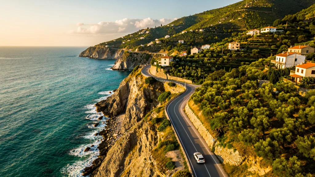
Route 2: Chapman’s Peak and the Cape Peninsula
This is the drive you do from Cape Town, and it may be the most scenic 80 km of coastal road in the world. Chapman’s Peak Drive itself is only 9 km, but the entire Cape Peninsula loop offers cliffs, penguins, mountains, and the tip of the continent.
Route details:
- Start/End: Cape Town
- Loop distance: ~80 km
- Drive time: 2-3 hours without stops
- Recommended time: Full day
| Stop | Route Position | Highlight |
|---|---|---|
| Hout Bay | Start of Chapman’s Peak | Fishing harbor, seal island boat trips (half day on boats), harbor restaurants |
| Chapman’s Peak Drive | Hout Bay to Noordhoek | 114 curves, 600m cliffs above the Atlantic; toll 52 ZAR |
| Noordhoek Beach | After Chapman’s Peak | 8-km stretch of wild beach, no development, Big Bay surf breaks |
| Simon’s Town | East coast | Naval town, Victorian architecture, Boulders Beach 3 km south |
| Boulders Beach | Near Simon’s Town | African penguin colony (walk among them); entrance 176 ZAR |
| Cape Point | Peninsula tip | Lighthouse, cliffs, nature reserve entrance, funicular option |
| Cape of Good Hope | Near Cape Point | The famous signpost, dramatic cliffs, southwesternmost point |
Chapman’s Peak Drive has a toll (52 ZAR / ~3 USD for cars) and is worth every cent. The road is carved into the cliff face 600 meters above the Atlantic, with 114 curves and viewpoints that make you want to stop every thirty seconds. The drive from north to south (Hout Bay to Noordhoek) puts the ocean on your left with unimpeded views; south to north has better pullover points. Drive it whichever direction fits your route, then ideally drive it again the other way — it is that good.
The road opened in 1922 after eight years of construction, blasted directly into the granite cliff face. Rockfall still occasionally closes sections for maintenance. Check the status at the toll gate before committing.
Boulders Beach (entrance: 176 ZAR / ~10 USD) puts you on a boardwalk through a colony of African penguins. They waddle between boulders, swim in the clear water, and ignore tourists with magnificent indifference. The colony numbers around 3,000 birds. It is absurd and delightful in equal measure.
Cape Point Nature Reserve (entrance: 376 ZAR / ~20 USD per adult, including Boulders if you show your ticket) covers the very tip of the peninsula. Drive to the upper parking area, then hike or take the funicular (120 ZAR) to the old lighthouse for views across the ocean. The new lighthouse on the point below is active; the old one above is the viewpoint. On a clear day, the view extends to the Hottentots Holland mountains 50 km away.
Full day itinerary suggestion: Start by 8:30 AM in Cape Town. Drive through Hout Bay (coffee stop), Chapman’s Peak Drive, Noordhoek (beach walk), Simon’s Town (lunch at a harbor restaurant), Boulders Beach, Cape Point, Cape of Good Hope. Return via the N2 or the Constantia wine valley for late afternoon wine tasting. Back in Cape Town by 18:00. This is a genuinely perfect day.
Chapman’s Peak — What to Watch for
Road closures: Chapman’s Peak is closed when wind speeds or rockfall risk reaches dangerous levels. This happens most commonly in winter (June-August). Check the official website (chapmanspeakdrive.co.za) or the Cape Town tourism board for status. There is an inland alternative via Ou Kaapseweg, but it is significantly less scenic.
Parking at Chapman’s Peak viewpoints: There are three main pull-off areas on the drive itself. All are small. In summer, they fill by late morning. If you want the viewpoints without competing for a spot, aim to drive Chapman’s Peak before 9 AM or after 4 PM.
Baboons on the Cape Peninsula: The Cape Peninsula has a resident baboon population that is habituated to cars and tourists. They will approach vehicles. Do not feed them. Keep windows closed when stationary near Cape Point. A baboon that has located a food source becomes a serious problem for both the baboon and the next car.
Route 3: Route 62 — The Inland Alternative
Route 62 is the non-coastal alternative between Cape Town and the Garden Route, running through the Little Karoo semi-desert, over mountain passes, and through wine and fruit farming towns. It is less famous than the Garden Route but arguably more authentically South African — less tourist infrastructure, more genuine small-town character, and dramatic Karoo scenery that the N2 coast entirely misses.
Route details:
- Start: Worcester (100 km from Cape Town via the N1 and Du Toitskloof Pass)
- End: Port Elizabeth (or join the N2 at Humansdorp)
- Distance: ~340 km (Worcester to Oudtshoorn)
- Drive time: 4-5 hours
- Recommended duration: 2-3 days
| Stop | Km from Worcester | Highlight | Don’t Miss |
|---|---|---|---|
| Robertson | 50 km | Wine valley, farm stalls, Robertson Wine Route | Robertson valley wine tasting from 80 ZAR |
| Montagu | 75 km | Hot springs, hiking, dried fruit producers | Avalon Springs thermal baths (200 ZAR) |
| Barrydale | 120 km | Art galleries, small-town vibe, Ronnie’s Sex Shop | The bar stop everyone makes (roadside legend) |
| Calitzdorp | 180 km | Port wine capital of South Africa | Die Krans or Boplaas port wine tasting |
| Oudtshoorn | 230 km | Ostrich farms, Cango Caves | Safari Ostrich Show Farm (entry 200 ZAR) |
| Prince Albert | 280 km (side trip via Swartberg Pass) | Karoo village, creative community, olive farming | Swartberg Pass itself |
Oudtshoorn is famous for two things: ostriches and caves. The ostrich farms are quintessentially South African — you can see the birds up close, learn about the feather trade that made this town wealthy enough to build “feather palaces” (several Victorian mansions still stand), and, if you are brave enough, ride one. The Cango Caves are 30 km north — a limestone cave system with chambers over 60 meters high. The standard tour (180 ZAR) covers the main chambers. The adventure tour (350 ZAR) involves crawling through passages as narrow as 27 cm. Choose based on your claustrophobia threshold.
The mountain passes on Route 62 are highlights in themselves. The Du Toitskloof Pass between Paarl and Worcester (or the longer Bain’s Kloof alternative, highly recommended) offers dramatic fynbos-covered mountain scenery. Cogmanskloof near Montagu is carved through a narrow gorge alongside the Keisie River. The Swartberg Pass (from Oudtshoorn toward Prince Albert) is the most dramatic: 27 km of gravel, 1,580 meters at the summit, tight hairpins, and extraordinary views across the Karoo. A standard rental car handles it at moderate speed — no 4x4 needed, but ground clearance helps. Budget 2-3 hours for the return trip over the pass and through Prince Albert.
Ronnie’s Sex Shop: Despite the name, it is a bar — a roadside diner that a local farmer named Ronnie painted “Ronnie’s Shop” on, then woke up to find friends had added extra text overnight. He kept it. It is now one of the most visited stops on Route 62, serves cold beer, has walls covered in bras left by travelers, and represents the Route 62 spirit perfectly.
Route 62 vs. Garden Route — Which to Choose
You do not have to choose. Many itineraries combine both: drive Route 62 inland from Cape Town to Oudtshoorn (2-3 days), then cross to the coast via the George turn-off and drive the Garden Route back east. This gives you the best of both landscapes without backtracking.
If you must choose: Garden Route for first-time visitors who want coastal scenery and easy infrastructure. Route 62 for return visitors, wine enthusiasts, those who find the Garden Route slightly too polished, and anyone who has read the phrase “authentic Karoo character” in three different travel guides and wants to see what it actually means.
Route 4: The Panorama Route — Mpumalanga
The Panorama Route runs along the edge of the Drakensberg escarpment in Mpumalanga province, offering canyon viewpoints, waterfalls, and access to the Kruger National Park. This is the most dramatic landscape in the eastern part of the country — a series of views that drop from 2,000 meters on the escarpment down 800 meters into the subtropical Lowveld below.
Route details:
- Start: Johannesburg or Nelspruit (Mbombela)
- Corridor: White River to Graskop
- Distance: ~250 km loop
- Drive time: 5-6 hours without stops
- Recommended duration: 2-3 days
| Stop | Highlight | Entry Fee | Notes |
|---|---|---|---|
| Blyde River Canyon | Third largest canyon in world, Three Rondavels viewpoint | 50 ZAR | Morning light is best |
| God’s Window | Panoramic viewpoint over the Lowveld; over 1,000 m drop | 25 ZAR | Bring a jacket; it is cold even in summer |
| Bourke’s Luck Potholes | Geological formations at canyon confluence, yellow-orange sandstone | 40 ZAR | Short walk from parking |
| Lisbon Falls | 94-meter waterfall in indigenous forest | 15 ZAR | Best in summer (rain season) |
| Berlin Falls | 80-meter single-drop waterfall | 15 ZAR | Accessible 5-minute walk |
| Pilgrim’s Rest | Historic gold mining village, preserved Victorian buildings | Free (village) | Excellent pub lunch; pay for house tour |
| Graskop | Gateway town, Graskop Gorge Adventure (zip-line), famous pancakes | Varies | Stop for the pancakes |
| Mac Mac Falls | Twin 65-meter waterfalls with swimming hole | 25 ZAR | 10 minutes from Graskop |
Blyde River Canyon is 26 km long and 800 meters deep — the third largest canyon in the world by some measures and the largest in Africa. The Three Rondavels viewpoint, where three massive rounded rock formations rise from the canyon floor (named for their resemblance to traditional circular huts), is the signature image. The canyon is green in summer and golden in winter — both are spectacular, but early morning light in either season is transformative.
God’s Window is the most aptly named viewpoint in South Africa. On a clear day, you can see the Lowveld stretching to Mozambique — a drop of over a thousand meters from the escarpment edge. On a misty day, the clouds fill the canyon below you while you stand in sunshine. Both experiences justify the stop. Bring a jacket regardless of the lowland temperature — the escarpment is dramatically cooler.
Pilgrim’s Rest is a perfectly preserved gold rush town from the 1870s. The entire village is a national monument. The Royal Hotel serves outstanding food (their bobotie is a benchmark). The house tours explain the gold fever that brought prospectors from around the world to this forest valley and made some of them very rich. By 1880, Pilgrim’s Rest was the richest small town in the Transvaal.
Combining with Kruger: The Panorama Route is the natural approach to Kruger National Park. From Graskop or White River, the Phabeni, Numbi, or Orpen gates are 60-90 minutes away. Many visitors combine 2-3 days on the Panorama Route with 3-5 days self-driving in Kruger. The Graskop/White River area has good accommodation at all budget levels, making it a practical base.
Kruger National Park Self-Drive — Specifics
If the Panorama Route leads you to Kruger, here is what to know about self-driving the park:
Entry: Multiple gates — Phabeni (closest from Graskop), Numbi, Paul Kruger (main gate), and Orpen. Reserve online at SANParks.org before arrival. Entry fees are 340 ZAR per person per day plus 440 ZAR per vehicle per day. For a vehicle with two people for three days, that is approximately 4,680 ZAR in entry fees alone — budget accordingly.
Self-drive rules: Speed limit is 50 km/h on tar roads, 40 km/h on gravel. Exit the vehicle only at designated rest camps and viewpoints. Gates open at sunrise and close at sunset — you must be at a rest camp or back at an exit gate by the listed close time or face a significant fine.
Best game viewing times: Early morning (6-9 AM) and late afternoon (3-6 PM). Midday is quiet — animals shelter from heat. We spent a midday hour at the Tshokwane picnic site (a pleasant spot with a small cafe) and then drove back out in the late afternoon to find lion within 20 minutes.
Car choice for Kruger: A standard compact manages Kruger’s main surfaced roads perfectly. The game drive loops (gravel) work fine for most cars. An SUV or crossover provides better visibility above the dry-season grass and handles the rougher gravel loops more comfortably. A 4x4 is not necessary.
Route 5: Cape Winelands Circuit
The Cape Winelands are not just a day trip from Cape Town — they deserve at least two days of self-drive exploration. Stellenbosch, Franschhoek, and Paarl form a triangle of wine estates, mountain scenery, and restaurants that competes with Tuscany on every metric except language.
Route details:
- Start/End: Cape Town
- Loop distance: ~150 km
- Drive time: 3-4 hours driving only
- Recommended duration: 2-3 days (including wine stops)
| Town | Distance from Cape Town | Highlight | Don’t Miss |
|---|---|---|---|
| Stellenbosch | 50 km via N2/R44 | Oak-lined streets, 17th-century Cape Dutch architecture | Tokara or Delaire Graff wine estate |
| Franschhoek | 75 km via N2/R45 | French Huguenot heritage, gourmet restaurants | Boekenhoutskloof or La Motte winery |
| Paarl | 55 km via N1 | Long Main Street, granite dome outcrops, wine route | Rupert & Rothschild, Spice Route |
| Constantia | 25 km from Cape Town | Oldest wine-producing valley in the Cape | Groot Constantia (oldest estate in SA, founded 1685) |
Tasting fees: Stellenbosch and Franschhoek estates typically charge 100-200 ZAR per person for tastings of 5-8 wines. This is refunded or discounted on purchases at many estates. Compared to Napa Valley (60-100 USD per tasting) or Burgundy, the value is extraordinary.
The Franschhoek wine tram: An open-air tram-bus that moves between wine estates on a hop-on/hop-off basis (ticket: 360-540 ZAR including wine tastings). If you want the full wine-estate experience without driving between them, this is the solution. The designated driver in your group will appreciate it. The tram runs four different routes and the full day experience includes 4-5 estates.
Driving the wine route: South Africa has a zero-tolerance approach to drink-driving (0.05% BAC limit). When wine tasting is on the agenda, designate a driver or use the wine tram. The roads between estates in Franschhoek Valley are beautiful — one of us drove while the other tasted, and we rotated estates. Less efficient than the tram, more flexible.
Winelands Beyond Stellenbosch and Franschhoek
Most visitors cover Stellenbosch and Franschhoek and consider the Winelands done. If you have an extra day, the following additions round out the picture:
Wellington: North of Paarl, 15 minutes from Paarl along the R301. Fewer tourists, more genuine agricultural character, and wine estates where you can often get a tasting without booking. Good for a quiet morning before the weekend crowds hit Franschhoek.
Elgin Valley: Southeast of Cape Town via the N2 over Sir Lowry’s Pass. Apple farming territory (the pass descent is lined with orchards) with a growing wine scene. Paul Cluver and Oak Valley are the standout estates. Cooler climate than Stellenbosch, which means excellent Sauvignon Blanc and Pinot Noir. Adding Elgin to a Winelands trip requires a longer itinerary but is rewarding.
Hermanus from the Winelands: From Franschhoek, the drive to Hermanus via Villiersdorp (R43) is about 2 hours through dramatically different landscape — from vine-covered valleys to apple-farming highlands to whale-watching coast. July-November, this drive can be combined into a single spectacular day.
Planning Tips
Car choice for each route:
| Route | Recommended Car | Reason |
|——-|—————-|——–|
| Garden Route, Cape Peninsula, Winelands | Economy or compact | Excellent paved roads throughout |
| Route 62 (Swartberg Pass) | Compact or small SUV | Gravel on the pass; higher clearance helps |
| Panorama Route | Compact or compact SUV | Mix of paved and light gravel |
| Kruger National Park self-drive | SUV or crossover | Game drive loops are gravel; flat tire risk on stones |
| Remote Karoo, Northern Cape | 4x4 | Side roads can be very rough; distances between help are long |
Season matters enormously. The Western Cape (Cape Town, Garden Route) is best in November-March (summer). The Kruger and Panorama Route are best in May-September (dry winter). Planning a single trip that covers both regions requires compromise — October/November or March/April are the best overlap months.
Book accommodation ahead on the Garden Route. December-January and Easter school holidays see the Garden Route fully booked. Reserve rooms 2-3 months ahead for peak periods. Knysna and Plettenberg Bay fill up fastest.
Fuel planning is straightforward on N-roads. All major routes have fuel stations at regular intervals (every 50-100 km). The exception is remote Karoo and Northern Cape routes, where fuel stops can be 150+ km apart. The Swartberg Pass gravel section has no fuel between Oudtshoorn and Prince Albert (75 km including the pass) — fill up before starting.
Start early, finish before dark. South African road trips are best done in daylight. Night driving on rural roads carries genuine risks (pedestrians, animals, unlit vehicles). Plan your driving to be complete by sunset. The light in the Western Cape from late afternoon is extraordinary — it is worth starting early to have slow afternoons in the places you want to photograph.
Self-driving Kruger: Kruger National Park allows self-drive in any car. You enter through a park gate, pay the entry fee (340 ZAR per person per day, plus 440 ZAR per vehicle per day), and drive the game loops. A higher vehicle helps for spotting animals above the tall dry-season grass. The main surfaced roads inside Kruger run between the rest camps; game drive loops are gravel. Speed limit inside the park is 50 km/h on tar and 40 km/h on gravel. Getting out of the vehicle is prohibited except in designated areas.
South Africa is left-hand traffic. If you are coming from a right-hand-traffic country, the first day will require conscious attention, particularly at junctions and roundabouts. The highway is easy — traffic flow orients you. Rural intersections and the first left turn out of the rental lot are the moments to slow down and think. You will adapt within a day.
For driving rules and safety specifics, see our South Africa driving guide. For cost planning, check car rental costs in South Africa. And for route planning that extends beyond South Africa, consider Mauritius as a complementary island destination reachable by direct flight from Johannesburg.