Best Road Trips in Reunion
Reunion has a density of spectacular roads that is almost unfair. The island measures 63 km by 45 km – you could fit it inside most European national parks – and yet it contains a volcanic lava road, three cirque roads with hundreds of switchbacks each, a tropical forest route through mountain passes, and a coastal drive with black sand beaches and sugar cane fields. We spent a week here and drove every major route, and the honest assessment is that there is not a dull kilometer on the island. Even the “boring” coastal highway has viaducts suspended above the ocean and tunnels cut through volcanic basalt.
The key planning decision is weather. The east coast and the mountains get rain regularly, while the west coast stays dry. Morning starts are essential for mountain drives – the clouds build by early afternoon and can erase your views entirely. We learned this the hard way on the Cilaos road: drove up in brilliant sunshine, had lunch, walked for two hours, and drove back down through a cloud so thick we could not see the valley we had been admiring two hours earlier. Start early. Every time.
Route Overview
| Route | Distance | Driving Time | Best Season | Highlights |
|---|---|---|---|---|
| Route des Laves (Volcano Road) | 50 km coastal + 27 km to summit | 1.5-2 hours (coastal) + 45 min (summit detour) | May-Nov | Active volcano, lava fields, lunar landscape |
| Cilaos Cirque Road | 37 km (Saint-Louis to Cilaos) | 1-1.5 hours | Year-round (dry season best) | 400+ curves, mountain village, lentil country |
| Salazie & Hell-Bourg | 30 km (Saint-Andre to Hell-Bourg) | 45 min-1 hour | Year-round | Waterfalls, Creole villages, Bridal Veil Falls |
| Coastal Circuit | 200 km (full circle) | 4-5 hours non-stop | Year-round | Beaches, towns, sugar cane, west coast lagoon |
| Interior Route (RN3) | 55 km (Saint-Pierre to Bourg-Murat) | 1 hour | Year-round | Steady climb through Plaine des Cafres, cattle country |
Route 1: Route des Laves – The Volcano Road
| Distance: 50 km (Sainte-Rose to Saint-Philippe coastal section) + 27 km detour to Pas de Bellecombe | Time: 1.5-2 hours coastal + 45 min summit detour | Difficulty: Easy to moderate (conditions permitting) |
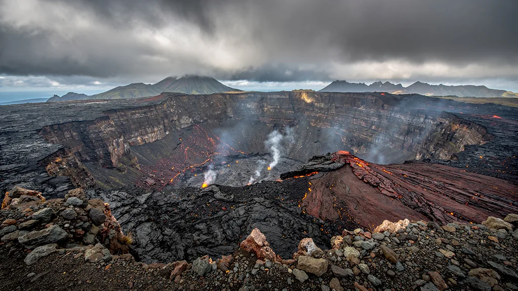
This road crosses the active flank of Piton de la Fournaise, one of the world’s most active volcanoes. It erupts roughly every year – sometimes twice. The landscape is lunar: black basalt lava flows stretching from the mountainside to the ocean, with patches of pioneer vegetation (ferns, Acacia mearnsii, endemic plants) slowly reclaiming the rock. Signs along the road mark individual lava flows by year, and you can trace the progression from bare black rock to scrubby ferns to tropical forest depending on how recent the eruption was. The 2007 flow that buried a large section of the road and was then rebuilt on top of the hardened basalt is the most striking example – you are literally driving on a road built on top of the previous road.
The coastal route: Drive the RN2 between Sainte-Rose and Saint-Philippe on the southeast coast. This 50 km section crosses multiple lava flows, passes through the village of Sainte-Rose (with its famous Notre-Dame-des-Laves church), and skirts the Anse des Cascades, a sheltered bay where multiple waterfalls cascade directly into the sea through a grove of palm trees. The Pointe de la Table at the southeastern tip is where the most recent significant lava flow (2007) created new land by reaching the ocean. You can walk to the edge of the old flow and look down at the basalt cliffs.
The volcano detour (Pas de Bellecombe): From Bourg-Murat on the Plaine des Cafres plateau, drive 27 km up the Route Forestiere de la Plaine des Cafres to the Pas de Bellecombe viewpoint at 2,311 meters. This is the main observation point overlooking the Enclos Fouque caldera – a massive crater more than 13 km in diameter – with the active Dolomieu summit crater visible inside. The drive itself is spectacular: the vegetation transitions from mountain heathland to near-alpine scrub, temperatures drop by 10-15 degrees, and the landscape becomes otherworldly. On a clear day (before 10 AM, preferably), the views are extraordinary. From the parking lot, a 45-minute walk leads to the crater rim.
Road closure protocol: The Route des Laves coastal section is the road most frequently closed on the island – not for construction but for actual lava. When Piton de la Fournaise erupts, depending on the flow direction, the RN2 can be blocked for days or weeks. Check status at the Observatoire Volcanologique de la Reunion (volcanologie.ipgp.fr) before the drive. Local radio (Radio Freedom, Radio RFO) also broadcasts alerts. If the road is closed, do not attempt to pass barriers – lava flows are unpredictable and have been known to accelerate unexpectedly.
Volcano Road Stops
| Stop | Distance from Sainte-Rose | Time Needed | Notes |
|---|---|---|---|
| Sainte-Rose village | Starting point | 15 min | Small harbor, local cafe |
| Notre-Dame-des-Laves church | 2 km south | 15 min | 1977 lava stopped at church steps |
| Anse des Cascades | 8 km south | 30-45 min | Waterfalls into sea, palm grove, picnic tables |
| Signed lava flow viewpoints | Various | 5 min each | Year markers for each eruption |
| Pointe de la Table | 30 km south | 20 min | 2007 flow, new coastline, dramatic views |
| Saint-Philippe village | 50 km south | 15 min | End of coastal lava section, garden cafes |
| Bourg-Murat (RN3) | Detour via interior | 30 min | Gateway to volcano road |
| Maison du Volcan (museum) | Bourg-Murat | 30-60 min | Interactive volcanic geology exhibits |
| Pas de Bellecombe viewpoint | 27 km from Bourg-Murat | 45 min + walk | Best volcano viewpoint, arrive before 10 AM |
Best approach: Start in Sainte-Rose at 8 AM, drive south to Saint-Philippe (1.5 hours with stops), then loop back north via the interior road through Le Tampon and Bourg-Murat to the volcano viewpoint. Return via the Plaine des Cafres to the coast. Full day, entirely different landscapes in every direction.
Route 2: Cilaos Cirque Road
| Distance: 37 km (Saint-Louis to Cilaos) | Time: 1-1.5 hours each direction | Difficulty: Moderate to challenging |
The road into the Cirque de Cilaos is legendary among driving enthusiasts. The statistics alone are impressive: over 400 curves in 37 km, climbing from near sea level to 1,200 meters through a landscape of ravines, waterfalls, and vertical cliff faces. The actual experience is better than the statistics suggest. Each switchback reveals a new angle on the cirque – the massive amphitheater walls, the waterfall threads, the village of Cilaos far below then suddenly beside you. The road was first built to connect the thermal springs of Cilaos to the coast, a project that required blasting tunnels through rock faces and constructing bridges over ravines that look like they should not support a bicycle, let alone a paved road. Today it is well-maintained and perfectly drivable, but it is never boring.
The route in detail: From Saint-Louis on the southwest coast, the RD242 heads inland immediately. The first section follows the valley floor with sugarcane fields on both sides before the road rises steeply into the cirque walls. The switchbacks begin in earnest around the first tunnel section – two-way tunnels cut through the cliff face that require waiting for oncoming traffic to clear. The road clings to the cliff, offering views down into the Bras de Cilaos ravine that will make passengers want to look anywhere else. After the second major tunnel section, the road drops briefly into the valley before the final climb to Cilaos town at 1,200 meters.
Cilaos town: The village is famous for three things: its lentils (Lentilles de Cilaos, Protected Geographical Indication, grown on the cirque terraces and available in every local restaurant), its embroidery tradition (a cottage industry dating back 150 years, sold in workshops and shops throughout town), and its thermal springs (the Etablissement Thermal Irene Accot, offering thermal baths, massages, and hydrotherapy). The air is cool, the pace is slow, and the food is excellent – a cari de cabri (goat curry) at a restaurant on the town square after the drive is a combination we unreservedly recommend.
The mountain community: Cilaos was isolated for much of its history – the cirque walls are so steep that before the road was built in 1932, access was by mule track only. The population today is about 8,000, and the community has a distinct character shaped by that isolation: its own dialect, its own cuisine, its own agricultural traditions. The lentils, the wine (yes, there is wine – the Vin de Cilaos, a light local production), and the embroidery all emerged from the necessity of creating within the cirque what could not be easily brought from outside.
Road conditions in detail: Narrow throughout, but manageable for standard cars. The maximum vehicle length is effectively limited by the tightest switchbacks – large vans and campervans are not suitable. Two small cars can pass on most of the road, but requires one to use a passing point on the narrowest sections. Some blind curves have mirrors installed at the apex – check the mirror before entering. The road surface is good but volcanic gravel from the cliff faces above occasionally appears, particularly after rain. Uphill traffic has informal priority on the steepest single-lane sections.
Honking protocol: One short beep before entering a blind hairpin is standard practice and expected. You will hear locals doing this; do the same. It warns oncoming traffic you are approaching and is not considered aggressive.
Cilaos Road Stops
| Stop | Distance from Saint-Louis | Time Needed | Notes |
|---|---|---|---|
| Tunnel du Bras de Cilaos (first tunnels) | 12 km | 5 min | One-way sections, wait for oncoming |
| Roche Merveilleuse viewpoint | 34 km | 20 min | Classic cirque panorama, 15 min walk |
| Cilaos thermal baths (Irene Accot) | 37 km | 1-2 hours | Thermal pools, massage, book in advance |
| Cilaos town center | 37 km | 1-2 hours | Lentil tasting, embroidery shops, market |
| Bras-Sec waterfall | 5 km from town | 30 min | Short detour, pleasant waterfall walk |
| Col du Taïbit viewpoint | 8 km from town | 45 min | Trail to cirque edge, views of Mafate |
| Wine cellars (Cave Coopérative) | In town | 30 min | Vin de Cilaos tasting, unique light wine |
Timing: Leave the coast by 7:30 AM for the best chance of clear views from the viewpoints. By 11 AM, clouds often fill the lower sections of the cirque. Allow the full day: drive up (1.5 hours with stops), spend 3-4 hours in Cilaos, drive down (1 hour). Do not try to rush the descent.
Route 3: Salazie and Hell-Bourg
| Distance: 30 km (Saint-Andre to Hell-Bourg) | Time: 45 minutes-1 hour each direction | Difficulty: Moderate |
The Cirque de Salazie is the most accessible of Reunion’s three cirques, and in many ways the most beautiful. The road is wider than Cilaos, the switchbacks are less extreme, and the landscape is more dramatically wet – waterfalls appear within the first 5 km of entering the cirque and continue for the entire drive. The Cascade du Voile de la Mariee (Bridal Veil Falls) is the signature sight: a 220-meter waterfall cascading down the cliff face directly beside the road, visible from multiple angles as you drive past. After heavy rain, it becomes a series of falls rather than a single cascade, and the road surface can have water running across it from smaller flows off the cliff.
The route in detail: From Saint-Andre on the northeast coast (the island’s sugar cane capital), the RD48 heads inland along the Riviere du Mat valley. The transition from coastal flatlands to tropical gorge happens quickly. Within 10 km you are in dense forest with waterfalls on both sides and the road carved into increasingly vertical cliff faces. The village of Salazie (not to be confused with the cirque) is a small market town with a fuel station – the only one until you return to the coast. From Salazie, the road continues through increasingly lush vegetation to Hell-Bourg.
Hell-Bourg: The name is misleading. Hell-Bourg is classified as one of France’s “Plus Beaux Villages” (Most Beautiful Villages), a designation it fully earns. The town was a fashionable thermal resort in the 19th century – the thermal springs that made Cilaos and Salazie famous were both developed during the colonial period. The Maison Folio is the best-preserved Creole villa on the island, with a garden of medicinal plants and an interior that shows the extraordinary craftsmanship of Reunion’s traditional wooden architecture. The embroidered wooden balconies, the louvered shutters, and the walled gardens make the town feel like it was preserved in amber in 1890. If you only have time for one village in the cirques, Hell-Bourg is our first choice.
Mare a Poule d’Eau: A small natural lake near Salazie, reachable by a 30-minute drive on a secondary road from the main route. On calm mornings, the lake reflects the surrounding peaks in mirror-perfect stillness. On rainy afternoons it is just a grey lake in the mist. Worth the detour if the weather is clear.
The wet season factor: Salazie is the wettest of the three cirques – the northeast orientation catches almost all the rain from the trade winds. Annual rainfall in the cirque can exceed 5,000 mm. This means waterfalls are spectacular but landslides are a real risk during the wet season (December-April). The road can close for hours after heavy rain. Check conditions at the local Prefecture website or ask at the rental desk before heading up in wet season.
Salazie Road Stops
| Stop | Distance from Saint-Andre | Time Needed | Notes |
|---|---|---|---|
| Entry to gorge | 8 km | Pull-over 5 min | First views of cliff walls |
| Cascade du Voile de la Mariee | 14 km | 15-20 min | Bridal Veil Falls, best at mid-morning light |
| Salazie village | 18 km | 15 min + fuel | Fuel station (only one in cirque), small market |
| Mare a Poule d’Eau | 20 km + 5 km detour | 30-45 min | Lake viewpoint, best on calm mornings |
| Hell-Bourg village | 30 km | 1.5-2 hours | Maison Folio, Creole architecture, cafes |
| Trou de Fer viewpoint | Trail from Hell-Bourg | Full day hike | Deep gorge with multiple waterfalls, not for casual visitors |
| Col des Boeufs | From Hell-Bourg | 1-2 hours driving + walk | Gateway viewpoint for Mafate cirque (no road into Mafate) |
Timing: The Salazie road can be driven in either direction – clockwise from Saint-Denis (north) or as a detour from the east coast drive. Start by 8 AM for the clearest views. Afternoons in the cirque are typically cloudy and often rainy.
Route 4: Coastal Circuit
| Distance: 200 km (full circle) | Time: 4-5 hours non-stop, full day with stops | Difficulty: Easy |
The drive around Reunion’s coast gives you the full portrait of the island’s contrasts within a single day. The west coast is dry, sunny, and turquoise-lagoon gorgeous. The south coast transitions through sugar cane and lava to dramatic volcanic coastline. The east coast is lush, wet, and wild. The north coast is urban Saint-Denis, colonial architecture, and traffic. Drive it in a day for the overview, then spend subsequent days in the inland areas you want to explore deeper.
The route in detail: Start from wherever you are based and go clockwise or counterclockwise. Most people drive it counterclockwise (north → east → south → west → north) to take the east coast in the morning before clouds build. The RN1 (west and north) and RN2 (east and south) form the nearly complete circle.
West coast (Saint-Denis to Saint-Pierre, RN1): This is the island’s showpiece coastal road. The Route du Littoral between Saint-Denis and La Possession is the most dramatic section – a 12 km stretch squeezed between cliffs and the Indian Ocean, with a partial viaduct section where the road is suspended above the water. The new Nouvelle Route du Littoral will eventually replace this section; currently construction affects traffic in the corridor. Beyond La Possession, the road opens up: Saint-Paul with its waterfront market, L’Ermitage and Boucan Canot beaches (white sand, reef-protected lagoon, turquoise water), Saint-Leu (surfing town, Kelonia sea turtle observatory), Saint-Louis, then Saint-Pierre. The west coast receives only 400-500 mm of rain per year – reliably sunny while the east drowns.
South coast (Saint-Pierre to Sainte-Rose, RN2): From Saint-Pierre, the road heads east past Grand Anse (a wide black sand beach with a rivermouth that occasionally floods the parking area after rains), Manapany-les-Bains, and the Cap Mechant viewpoint where the volcanic coastline is exposed in its most dramatic form – black rock, crashing waves, spray. Beyond Saint-Philippe, the road transitions into the Route des Laves section (Route 1 above), with lava flows reaching the coast.
East coast (Sainte-Rose to Saint-Denis, RN2): The eastern shore is a different planet from the west. Annual rainfall here reaches 4,000-8,000 mm. The vegetation is extravagant tropical lushness – everything is green, damp, and growing. The road passes through sugar cane fields interspersed with vanilla plantations (Reunion is a major vanilla producer), fishing villages, and the Riviere des Roches delta with its basalt canyon accessible by a 30-minute walk. Saint-Benoit is the main town; further north, the Grand Etang mountain lake is worth a 20-minute detour from the main road.
Coastal Circuit Highlights by Section
| Section | Key Stops | Distance | Driving Time | Character |
|---|---|---|---|---|
| Saint-Denis to Saint-Paul | Route du Littoral, La Possession, Saint-Paul market | 35 km | 40-50 min | Urban → coastal |
| Saint-Paul to Saint-Pierre | L’Ermitage beach, Boucan Canot, Saint-Leu, Kelonia | 70 km | 1.5-2 hours | Best beaches, sunny coast |
| Saint-Pierre to Saint-Philippe | Grand Anse, Cap Mechant, Saint-Philippe | 45 km | 1 hour | Black sand, volcanic coast |
| Saint-Philippe to Sainte-Rose | Route des Laves (see Route 1) | 50 km | 1.5 hours | Lava fields, volcano flank |
| Sainte-Rose to Saint-Denis | Riviere des Roches, Grand Etang, Saint-Benoit | 50 km | 1-1.5 hours | Lush east coast |
Route 5: The Interior Route (RN3 / Plaine des Cafres)
| Distance: 55 km (Saint-Pierre to Bourg-Murat) | Time: 1 hour | Difficulty: Easy |
This is not the island’s most famous road, but it is the most useful one for visitors planning volcano drives. The RN3 climbs steadily from Saint-Pierre on the south coast through Le Tampon and across the Plaine des Cafres plateau to Bourg-Murat at 1,400 meters – the base for the volcano road. The Plaine des Cafres is cattle farming country: wide, cool, foggy in the afternoons, completely unlike the tropical coast below. If you arrive expecting the tropics and find yourself in what feels like a Scottish highland with cattle and dairy farms, you are on the right road.
From Bourg-Murat, the Route Forestiere continues 27 km to the Pas de Bellecombe viewpoint (2,311 m). This upper section is narrower and requires more concentration – it is a genuine mountain road, steep in places, with fog appearing suddenly at altitude. The rule applies: before 10 AM for clear views.
The RN3 also connects to the Route des Plaines, which runs east across the Plaine des Cafres and Plaine des Palmistes to rejoin the east coast near Saint-Benoit. This cross-island route offers another angle on the island’s interior – different from the cirque roads but equally remote-feeling.
Combining Routes: 5-7 Day Itinerary
This island rewards a full week. The cirques alone justify the trip, and every route offers something genuinely different.
| Day | Route/Activity | Base | Notes |
|---|---|---|---|
| Day 1 | Arrive, Saint-Denis or west coast drive | Saint-Denis or Saint-Paul | Do not tackle mountain roads after a long flight |
| Day 2 | Cilaos Cirque Road (Route 2) | Saint-Pierre or Saint-Denis | Early start, full day, lentil lunch in Cilaos |
| Day 3 | Salazie and Hell-Bourg (Route 3) | Saint-Denis or east coast | Drive east coast on the way back |
| Day 4 | Volcano road (Route 1 coastal + Pas de Bellecombe) | Saint-Pierre or coastal south | Start 6 AM for summit visit before clouds |
| Day 5 | South coast + west coast beaches | Saint-Paul or Saint-Gilles | Beach day, surf at Saint-Leu, Kelonia |
| Day 6 | Coastal circuit (Route 4) or hiking at preferred cirque | Any | Last full driving day |
| Day 7 | Depart | Saint-Denis | RN2 or RN1 to airport |
Car recommendation: A compact car (Dacia Sandero, Peugeot 208) handles all of these routes without difficulty. A small SUV (Dacia Duster) gives more power on the switchbacks and slightly higher clearance for the rougher sections near the volcano. No 4WD or off-road capability is required – all routes described here are on paved roads.
Planning Tips
Start mountain drives early. Before 8 AM if possible. Mountain clouds build from late morning – by 2 PM the cirques and volcano are often socked in fog. We have lost views completely after arriving at the summit at 1 PM. The best light and clearest views are in the first hours after sunrise.
Fuel strategy. Fill up completely before any mountain excursion. Cilaos has one station in town. Salazie has one station in Salazie village. The volcano road (Route Forestiere to Pas de Bellecombe) has no fuel stations whatsoever from the coast to the summit. The universal Reunion driving rule: full tank before mountains.
Check volcano status. The Route des Laves can close with no advance notice during an eruption. Check volcanologie.ipgp.fr before planning any southeast coast or volcano drive.
Weather on the same day. The west coast can be sunny and 28 degrees C while the interior cirques are shrouded in cloud and 15 degrees C. Check the weather for both the coast and the specific interior area you are planning to visit.
Vehicle size. The Cilaos road is manageable in a standard compact car but uncomfortable in anything wider than a mid-size. Large SUVs and vans will find the tightest sections stressful. Small is better in the cirques.
Rain gear. Even in dry season, mountain areas can get sudden showers. A light rain jacket is useful for viewpoint stops. Mountain temperatures are 10-15 degrees cooler than the coast – if you plan to spend time at altitude, bring a layer.
For driving rules specific to mountain roads, see our Reunion driving guide. Budget planning is in our costs guide. For airport pickup and car selection, see our airport rental guide. Mauritius is a 40-minute flight away for Indian Ocean island-hopping.