Best Road Trips in Mauritius
Mauritius is an island where no drive exceeds 90 minutes but every drive delivers something worth stopping for. The distances are almost absurdly short – the entire coastline is about 330 km – yet the landscape changes with startling speed. In the time it takes to drive from Grand Baie to the Black River Gorges (about 75 minutes), you pass through beach resort territory, Port Louis’s urban sprawl, sugarcane plains, and volcanic mountain forest. Each transition is dramatic, and the temptation to stop is constant.
We drove every route below over six days, covering roughly 800 km total. The highlights reel includes a waterfall that drops into a volcanic crater, a seven-colored earth formation that looks photoshopped, a Hindu temple floating on a lake at 500 meters elevation, and a coastal road along the wild south where the Indian Ocean crashes against black basalt with nobody watching.
Route Comparison
| Route | Distance | Drive Time | Difficulty | Best Season | Highlights |
|---|---|---|---|---|---|
| Black River Gorges Circuit | 95 km | 2.5 hours (driving) | Moderate (mountain roads) | May-November | Gorges, waterfalls, Chamarel |
| Wild South Coast | 70 km | 2 hours (driving) | Easy-Moderate | Year-round | Cliffs, Gris Gris, Rochester Falls |
| Northern Beaches Loop | 50 km | 1.5 hours (driving) | Easy | Year-round | Beaches, Cap Malheureux, Grand Baie |
| Tea & Temple Highland Route | 60 km | 2 hours (driving) | Easy-Moderate | May-November | Grand Bassin, Bois Cheri, viewpoints |
| East Coast Discoveries | 65 km | 2 hours (driving) | Easy | Year-round | Belle Mare, Mahebourg, Blue Bay |
| Island Circumnavigation | 175 km | 4-5 hours | Moderate | May-October | All coastline regions |
Planning note: All routes below are described as one-way journeys or circuits. Times shown are driving time only – add 1-3 hours per route for stops, photography, swimming, and meals. A “half day” route typically occupies a full day when properly enjoyed.
Black River Gorges Circuit
This is the signature drive of Mauritius and the one that shatters the stereotype of the island as nothing but beaches. The Black River Gorges National Park covers 6,574 hectares of native forest, dramatic gorges, and volcanic peaks that rise to 828 meters. The road through and around the park is one of the most scenic island drives we have done anywhere.
The Route
Flic en Flac / West Coast → Tamarin (12 km, 15 minutes)
Start from the west coast. Tamarin is a laid-back surf town with a beautiful bay, dolphin-watching boats, and salt pans that have been harvested for centuries. The salt pans at sunset are a classic Mauritian photo opportunity. Stop for a morning coffee at one of the beachfront cafes.
The bay at Tamarin was historically where bottlenose dolphins were spotted daily in the early morning. Dolphin-watching boats depart from Tamarin at around 06:30-07:00 for a 3-hour trip (1,500-2,500 MUR / $33-56 per person). If dolphins are a priority, book ahead – spaces fill quickly.
Tamarin → Casela Nature Parks (5 km, 10 minutes)
A short drive south along the coast road. Casela is Mauritius’s main wildlife and adventure park – zip lines, safari trucks, and encounters with giant tortoises. If you are interested, allow 2-3 hours. Entry is 900-1,200 MUR ($20-27) depending on activities chosen. If wildlife parks are not your thing, skip it and continue south.
Casela → Black River Gorges Visitor Center (18 km, 30 minutes)
Drive inland and uphill through sugar cane fields to the Black River Gorges National Park entrance. The road climbs steadily from sea level to about 400 meters. The visitor center (on the road between Black River and Chamarel) has maps, trail information, and clean restrooms. From here, the park road climbs through native forest to several viewpoints.
GPS coordinates for Black River Gorges Visitor Center: -20.3858, 57.3877
Gorges Viewpoint (within the park)
The main viewpoint looks down into the gorge – a deep, forested valley carved by the Black River. On a clear morning, the depth and the density of the green forest are breathtaking. Short walking trails (15-30 minutes) lead to additional viewpoints. The Parakeet viewpoint and the Piton de la Petite Riviere Noire trail both start from this area.
Allow at least 45 minutes at the gorge viewpoints. Morning is best for light (the gorge faces east). By midday, the valley often fills with cloud.
Gorges → Chamarel (15 km, 25 minutes)
Continue on the park road south to Chamarel. This small highland village is home to two of Mauritius’s most famous attractions:
- Chamarel Waterfall: A 100-meter waterfall dropping into a densely forested gorge. Visible from a viewpoint (250 MUR / $5.50 entry) and genuinely spectacular. Best seen in the morning when sunlight hits the falls. Combined entry with the Seven Coloured Earth.
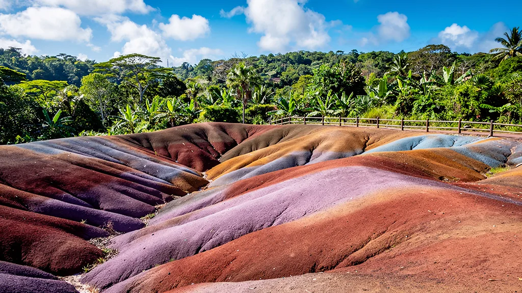
- Seven Coloured Earth (Terres de Sept Couleurs): A geological formation where volcanic earth has oxidized into distinct bands of red, brown, violet, green, blue, and purple. It looks artificial but is entirely natural. The effect is most vivid before noon, when shadows reduce the color contrast. Entry combined with the waterfall is 250 MUR ($5.50).
Chamarel → La Rhumerie de Chamarel (2 km, 5 minutes)
A working rum distillery with tours and tastings. The tour (400 MUR / $8.90) covers the distillation process, and the tasting includes their award-winning aged rums. The restaurant here serves excellent Mauritian cuisine with a view of the sugar cane fields. We had the grilled swordfish with coconut rice and it was the best meal of our Mauritius trip.
Chamarel → Le Morne (20 km, 30 minutes)
Descend back to the coast via the winding mountain road. Le Morne Brabant, a dramatic UNESCO-listed basalt peak jutting 556 meters from the southwestern corner of the island, comes into view as you descend. The descent road is steep and winding – take care in wet conditions. Le Morne peninsula below is one of the most beautiful beach areas in Mauritius: kitesurfers on the lagoon, the mountain backdrop, and a long white sand beach that faces west for spectacular sunsets.
Stop for a swim or continue along the coast.
Le Morne → Starting point (25 km, 30 minutes)
Follow the coast road north back to your base.
Planning Tips for the Black River Gorges Circuit
- Full day. This circuit deserves an entire day with all stops. Leave by 08:00 to maximize morning light.
- Start early. Morning light is best for the gorge viewpoints and Chamarel waterfall. The Seven Coloured Earth is most vivid before noon.
- Fuel up before. The mountain section has no fuel stations. Fill up in Tamarin or Flic en Flac before heading up.
- Rain check. The highlands receive significantly more rain than the coast. If the morning is cloudy on the coast, the viewpoints may be foggy. Weather apps that show elevation-specific conditions help.
- Wet season caution. The road to Chamarel can have slippery sections after rain. Drive slowly on the descent and avoid the route if there has been heavy overnight rain.
- Picnic alternative. The Chamarel rhumerie restaurant is good but a Mauritian picnic purchased from a market beforehand (roti, curry, fresh fruit) is an excellent and cheaper alternative.
Black River Gorges Driving Notes
The road from Black River town to the gorge visitor center climbs through sugar cane and native forest on a two-lane road that narrows to one lane in some sections. In harvest season (June-December), you may encounter sugar cane trucks descending – pull aside and let them pass. The truck drivers are experienced and appreciate the courtesy.
The Chamarel village road is narrow, winding, and spectacular. There is room for two cars to pass carefully. On very tight corners, slow to 10 km/h and edge through.
Wild South Coast
The south coast of Mauritius is the island’s untamed edge – dramatic cliffs, crashing waves, no resort hotels, and a rugged beauty that contrasts sharply with the manicured north. This route follows the coast from Souillac to Mahebourg, touching fishing villages, waterfalls, and coastline that feels genuinely remote despite being on a small island.
The Route
Souillac → Gris Gris Cliffs (2 km, 5 minutes)
Start at Gris Gris, the southernmost point of Mauritius. Here, the lagoon that protects most of the island’s coastline is absent, and the Indian Ocean hits the basalt cliffs with full force. The waves explode upward in white spray, and the wind is constant. Walk along the cliff-top path (10-15 minutes) for dramatic views. No entry fee, no facilities – just raw coastline.
The name “Gris Gris” refers to traditional African magic charms, and local legend holds that sorcerers would come here to cast spells into the sea. The spot has genuine energy regardless of your views on sorcery.
Gris Gris → Rochester Falls (8 km, 15 minutes)
Drive east to Rochester Falls, a waterfall notable for its rectangular basalt columns that look like they were cut by a mason. The angular formations are the result of rapid lava cooling – the same geological process that creates hexagonal basalt everywhere, but here producing unusually regular rectangular shapes.
The falls are about a 10-minute walk from the parking area through sugar cane fields. Entry is free. The pool below is swimmable if the flow is moderate. Best visited in the morning before the school groups and tour buses arrive.
Rochester Falls → Bel Ombre (20 km, 25 minutes)
Head west along the coast through Riviere des Galets and Saint Felix. The road passes through sugar estates and small villages with views of the mountains to the north and the sea to the south. Bel Ombre has a heritage estate with colonial-era buildings, tropical gardens, and a restaurant (Chateau de Bel Ombre). Worth a stop for lunch or a walk through the gardens.
Bel Ombre → Pont Naturel (10 km, 15 minutes)
Continue west to Pont Naturel, a natural rock bridge carved by the sea. It is a short walk from the road (the turning is unsigned; look for a parking area next to a gap in the vegetation, about 2 km east of the Beaux Songes roundabout). The bridge itself is dramatic, with waves crashing underneath, and the surrounding coastline is equally wild.
Pont Naturel → Blue Bay (30 km, 40 minutes)
Drive east along the south coast through Mahebourg and around to Blue Bay, one of Mauritius’s premier snorkeling spots. The bay is a marine park with clear water and coral just meters from shore. Glass-bottom boat trips cost 300-500 MUR ($6.70-11.10) and are worthwhile even for non-swimmers.
Blue Bay beach itself is one of the nicest on the island: calm turquoise water, fine white sand, and casuarina trees providing shade. The lagoon here is protected from the Indian Ocean swell by the outer reef, making it excellent for swimming and appropriate for children.
Planning Tips for the Wild South Coast
- Half to full day. The driving is about 2 hours total, but stops add up.
- Pack lunch. Restaurant options are limited along the south coast. Bel Ombre is the exception. A picnic from Mahebourg market is perfect.
- Swimming spots. Blue Bay is the best swimming on this route. Rochester Falls has a natural pool. The south coast cliffs are for viewing, not swimming.
- Sundays. Mahebourg market operates on Sunday mornings and is an authentic local experience – fresh fruit, dholl puri vendors, and local crafts.
- East of Blue Bay. The area around Mahebourg and the lagoon south toward Pointe d’Esny has excellent snorkeling. The Mahebourg waterfront museum is also worth an hour.
South Coast Road Conditions
The south coast road is generally well-maintained on the western section (Bel Ombre to Souillac) and slightly rougher on the eastern section (Souillac to Mahebourg). Speed bumps are frequent through villages. The road surface near Gris Gris is cracked in places – drive at 40 km/h on the approach.
Northern Beaches Loop
The north coast is where most tourists stay, and for good reason – the beaches are sheltered by the reef, the water is warm and calm, and the infrastructure is tourist-friendly. This route connects the best beaches and viewpoints in the north.
The Route
Grand Baie → Cap Malheureux (10 km, 15 minutes)
Drive north from Grand Baie along the coast road. Cap Malheureux is the northernmost point of the island, famous for its red-roofed church (Notre Dame Auxiliatrice) set against a backdrop of turquoise sea with Coin de Mire island on the horizon. It is one of the most photographed scenes in Mauritius, and with good reason. The village itself is quiet and uncommercial – a pleasant contrast to Grand Baie.
Coin de Mire (the teardrop-shaped island visible offshore) was a pirate base in the 18th century. Day boat trips depart from Grand Baie for snorkeling around the island (800-1,200 MUR / $17-27 per person).
Cap Malheureux → Pereybere Beach (5 km, 10 minutes)
Head back south along the coast. Pereybere is a public beach with excellent swimming, clear water, and a more local atmosphere than the resort beaches. Food stalls along the beach sell dholl puri (Mauritian flatbread with split pea filling) for 15-25 MUR ($0.33-0.55) – arguably the best quick meal on the island. There are also good reef snorkeling spots accessible from shore.
Pereybere → Grand Baie (3 km, 5 minutes)
Continue to Grand Baie. The bay is filled with catamarans and tour boats. The town has restaurants, shops, and two shopping centers. Good for lunch or browsing.
Grand Baie → Trou aux Biches (8 km, 12 minutes)
Drive west along the coast. Trou aux Biches has one of the island’s most beautiful beaches – a long stretch of white sand backed by casuarina trees. The swimming is excellent and the reef is close enough for snorkeling from shore. The road follows the coast closely with intermittent sea views.
Trou aux Biches → Mont Choisy (5 km, 8 minutes)
Continue west to Mont Choisy, another lovely beach with fewer crowds. The long sandy bay is popular for evening walks and sunset views.
Mont Choisy → Pointe aux Canonniers (8 km, 12 minutes)
Loop back east to this small peninsula with a colonial-era lighthouse and quiet beaches.
Pointe aux Canonniers → Pamplemousses (12 km, 20 minutes)
The Sir Seewoosagur Ramgoolam Botanical Garden at Pamplemousses is one of the oldest botanical gardens in the Southern Hemisphere, established in 1770. The giant lily pads (Victoria amazonica) are the main attraction, along with hundreds of tropical plant species. Entry is free. Allow 1.5-2 hours.
Planning Tips for the Northern Beaches Loop
- Half day, relaxed pace. This is a beach-hopping route – no major attractions, just beautiful water and sand.
- Best on weekdays. Northern beaches get busy with locals on weekends, especially Sunday.
- Snorkeling gear. Bring your own or rent from beach vendors (200-300 MUR / $4.40-6.70 per day).
- Pamplemousses timing. The garden is best in the morning before tour groups arrive. The lily pads are most impressive November-May when fully open.
Tea and Temple Highland Route
The central highlands of Mauritius occupy a volcanic plateau at 500-600 meters elevation. The air is cooler, the vegetation is lush, and two of the island’s most important cultural and natural landmarks are here.
The Route
Curepipe → Trou aux Cerfs (2 km, 5 minutes)
Start in Curepipe, the largest town on the central plateau. Trou aux Cerfs is a dormant volcanic crater, now a circular park with a paved road around the rim. The views from the top extend across the island on clear days. Free entry, 15-minute walk around the rim.
Curepipe itself is worth a brief stop: it has the best market for Mauritian handicrafts and the Rault biscuit factory (famous for Mauritian manioc biscuits, sold fresh from the door at about 100 MUR/$2.20 per tin).
Trou aux Cerfs → Grand Bassin (15 km, 25 minutes)
Drive south through the highland tea country to Grand Bassin (Ganga Talao), a sacred lake in a volcanic crater. This is the most important Hindu pilgrimage site outside India in the Southern Hemisphere. A 33-meter statue of Shiva guards the entrance, and the lakeside temples are colorful, active, and welcoming to respectful visitors. Entry is free. Dress modestly (cover shoulders and knees).
The lake sits at 500 meters elevation in a forest crater. The reflection of the temple on the still water in the early morning is genuinely beautiful. Bring an offering (flowers are available from vendors at the entrance) and join the temple visit – it is participatory, not just spectator.
During Maha Shivaratri (February-March), over 500,000 pilgrims walk from across the island to Grand Bassin. If you happen to be visiting during this time, expect road closures and heavy foot traffic on the routes leading to the lake. Consider parking 3 km away and joining the pilgrims on foot – the experience is extraordinary.
Grand Bassin → Bois Cheri Tea Factory (12 km, 20 minutes)
Continue south to Bois Cheri, Mauritius’s most famous tea plantation, dating from 1892. The factory tour (350 MUR / $7.80) covers the picking, processing, and tasting of Mauritian tea. The plantation grounds are beautiful (rows of tea bushes on the hillside, Indian Ocean visible in the distance), and the attached museum covers the history of tea on the island. The tasting pavilion has views across the southern coast.
The tasting itself covers several varieties: orange pekoe, green tea flavored with vanilla and coconut, and the premium “Grand Cru” blend. The gift shop has excellent prices on tea to bring home.
Bois Cheri → La Vanille Nature Park (10 km, 15 minutes)
Head south to this nature reserve, home to giant Aldabra tortoises, Nile crocodiles, and a butterfly garden. Entry is 525 MUR ($11.70). The tortoises are the highlight – ancient, enormous, and entirely comfortable being photographed.
Giant tortoises can live for 200 years, which means some of the residents may have been alive during the Napoleonic Wars. This fact seems impossible, and yet there they are, eating hibiscus flowers and being photographed.
La Vanille → Starting point via motorway (35 km, 40 minutes)
Return north via the motorway.
Planning Tips for the Tea & Temple Route
- Morning for Grand Bassin. The lake is most atmospheric in the early morning mist, before tour groups arrive.
- Respectful clothing. Grand Bassin is an active religious site. Cover shoulders and knees, remove shoes at temple entrances.
- Tea tasting. Book the Bois Cheri tour in advance during peak season (December-January). In low season, walk-ins are fine.
- Highland weather. The plateau is cooler and wetter than the coast. Bring a light jacket and expect the possibility of fog or drizzle.
East Coast Discoveries
The east coast of Mauritius is less visited than the north and west, which makes it more interesting. Belle Mare has the finest beach on the island. Mahebourg is a charming colonial town. The lagoon at Blue Bay is the best marine park.
The Route
Belle Mare Beach (from airport: 20 km, 25 minutes)
Belle Mare has arguably the finest beach on the island – a 3 km stretch of powdery white sand with exceptionally clear water and a wide lagoon. The east coast faces the prevailing Indian Ocean trade winds, making the sea choppier than the north (though still very swimmable). The wind also means kitesurf and windsurf lessons are available here.
Belle Mare → Mahebourg (25 km, 30 minutes)
Drive south along the east coast road through Vieux Grand Port and Ferney. Mahebourg is a charming colonial town built around the Battle of Grand Port (1810) – the only naval victory depicted on the Arc de Triomphe in Paris, and a rare French naval defeat. The Mahebourg National History Museum (free) covers the battle and colonial history in detail. The waterfront has good local restaurants serving fresh catch.
Mahebourg → Blue Bay Marine Park (10 km, 15 minutes)
Blue Bay is the best snorkeling site in Mauritius. The marine park protects a coral reef with visibility of 10-20 meters and a variety of fish, rays, and sea turtles. Snorkel from shore or rent a glass-bottom boat for 300-500 MUR ($6.70-11.10). The beach is one of the island’s nicest.
Planning Tips for East Coast Discoveries
- Best in morning. Belle Mare is windier than the north coast but cleaner – morning is ideal.
- Combine with south coast. The east coast and south coast can be combined into a full-day circuit from the airport area.
- Ferney Butterfly Garden. Between Belle Mare and Mahebourg, the Ferney valley has a nature reserve and butterfly garden worth a stop (500 MUR / $11).
Building Your Itinerary
3-Day Essential
| Day | Route | Accommodation |
|---|---|---|
| Day 1 | Airport pickup → Northern Beaches Loop | Grand Baie or Trou aux Biches |
| Day 2 | Black River Gorges Circuit (full day) | Same |
| Day 3 | Wild South Coast + Blue Bay → return car | Airport or hotel |
5-Day Complete Mauritius
| Day | Morning | Afternoon/Evening |
|---|---|---|
| Day 1 | Airport pickup, Northern Beaches | Grand Baie sunset |
| Day 2 | Black River Gorges, Chamarel waterfall | Seven Coloured Earth, Le Morne |
| Day 3 | Wild South Coast (Gris Gris, Rochester) | Blue Bay Marine Park |
| Day 4 | Tea & Temple Route (Grand Bassin, Bois Cheri) | La Vanille, southern villages |
| Day 5 | East Coast (Belle Mare, Mahebourg) | Return car, flight |
1-Day Highlights (Single Day Rental)
| Time | Stop | Time at Stop |
|---|---|---|
| 08:00 | Leave Grand Baie | – |
| 09:30 | Chamarel waterfall | 1 hour |
| 10:30 | Seven Coloured Earth | 45 minutes |
| 12:00 | Rhumerie de Chamarel lunch | 1.5 hours |
| 14:00 | Le Morne beach swim | 1 hour |
| 15:30 | Grand Bassin temple | 1 hour |
| 17:00 | Sunset at Flic en Flac beach | 1 hour |
| 18:00 | Return north | – |
Useful Fuel Stops
| Location | On Route | Note |
|---|---|---|
| Tamarin | Black River Gorges circuit | Fill before heading into mountains |
| Curepipe | Highland route | Fill at the central plateau start |
| Mahebourg | South coast / east coast | Fill before leaving the main road |
| Souillac | South coast start | Small station; confirm hours |
For driving rules and tips, see our driving guide. Budget your trip with our costs guide. For nearby island adventures, check Reunion and Seychelles.