Best Road Trips in Morocco
Morocco has a way of making every drive feel like an expedition. We set off from Marrakech on what the map said was a five-hour drive to Ouarzazate, and it turned into an eight-hour journey because we kept stopping. A Berber village clinging to a hillside. A valley full of almond blossoms. A pass at 2,260 meters where the air was sharp and the view stretched to the Sahara. You cannot not stop. The scenery demands it.
What makes Morocco exceptional for road trips is the compression. In a country slightly smaller than France, you get the High Atlas mountains, the Sahara Desert, the Atlantic coast, Mediterranean cliffs, cedar forests, and palm-filled oases. A two-week trip can cover all of these without any single driving day exceeding six hours. The autoroutes get you between cities fast; the mountain and desert roads deliver the experiences.
Route Overview
| Route | Distance | Driving Time | Best Season | Highlights |
|---|---|---|---|---|
| Marrakech to Sahara (Erg Chebbi) | 560 km | 8-10 hours (2 days) | Sep-May | Tizi n’Tichka pass, Ouarzazate, Dades Valley |
| Dades & Todra Gorges Loop | 300 km | 5-6 hours | Year-round | Gorge roads, kasbahs, palm groves |
| Atlantic Coast (Essaouira-Agadir) | 170 km | 3 hours | Year-round | Beaches, surf towns, argan cooperatives |
| Fes to Chefchaouen | 200 km | 4 hours | Mar-Nov | Rif Mountains, blue city, mountain roads |
| Grand Tour (Marrakech Circuit) | 1,400 km | 5-7 days | Sep-May | Everything: mountains, desert, coast |
Route 1: Marrakech to the Sahara via Tizi n’Tichka
| Distance: 560 km (one way) | Time: 2 days recommended | Difficulty: Moderate |
This is Morocco’s signature road trip, and it deserves every word of praise it gets. You start in the red-city buzz of Marrakech and end at the golden dunes of Erg Chebbi in the Sahara, crossing the High Atlas Mountains in between. The landscape changes so dramatically that by the time you reach the desert, Marrakech feels like a different country.
Day 1: Marrakech to Ouarzazate (190 km, 4-5 hours)
Leave Marrakech heading southeast on the N9. The road climbs steadily through the Haouz plain before entering the Atlas Mountains. The ascent to the Tizi n’Tichka pass (2,260 meters) is the highlight – a series of switchbacks through increasingly dramatic mountain scenery. The road is well-paved and two lanes, but the trucks grind slowly uphill, creating overtaking situations that require confidence and clear visibility.
At the summit, pull over at one of the roadside stalls for mint tea and the panoramic view. On a clear day, you can see the desert to the south. The descent toward Ouarzazate passes through the Ounila Valley, with optional detours to Ait Benhaddou (the fortified village used as a set in Gladiator, Game of Thrones, and approximately forty other movies – it is genuinely worth the 20 km detour).
Ouarzazate itself is a functional town rather than a beauty, but it has good hotels, decent restaurants, and the Atlas Film Studios if you are curious about Morocco’s Hollywood-of-the-desert role.
Day 2: Ouarzazate to Merzouga/Erg Chebbi (370 km, 5-6 hours)
Head east on the N10 through the Dades Valley, also known as the “Valley of a Thousand Kasbahs.” The name is barely an exaggeration – crumbling mud-brick fortresses line both sides of the road against a backdrop of red-rock formations. The turnoffs to Dades Gorge and Todra Gorge are along this stretch (see Route 2).
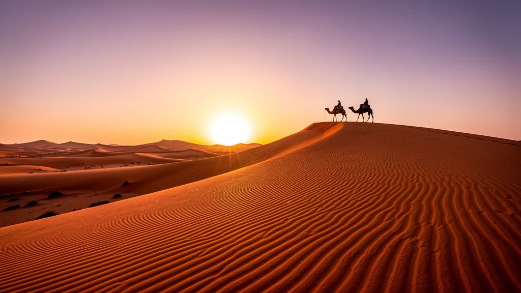
Continue east through Tinghir, Goulmima, and Errachidia. The landscape flattens and dries as you approach the Tafilalet region, with palm oases punctuating the stony desert. The final stretch from Rissani to Merzouga takes you to the foot of Erg Chebbi – a 22 km expanse of sand dunes rising up to 150 meters. Park the car, arrange a camel trek or 4x4 excursion to a desert camp, and watch the sunset turn the dunes from gold to red to purple.
Best stops:
- Tizi n’Tichka pass viewpoint (30 minutes)
- Ait Benhaddou (1-2 hours, 20 km detour from N9)
- Ouarzazate Atlas Film Studios (1 hour, optional)
- Skoura palm grove and kasbah (30 minutes)
- Rissani souk (30 minutes, if market day)
- Erg Chebbi dunes (overnight recommended)
Road conditions: N9 over the pass is well-maintained but winding with steep grades. The N10 east of Ouarzazate is straight and flat – easy but monotonous. The road to Merzouga is paved all the way.
Tizi n’Tichka Pass – Detailed Notes
The Tizi n’Tichka (2,260 meters) is the highest paved mountain pass in Morocco and the main highway crossing of the High Atlas. Despite its importance, the road remains two lanes for most of its length, and the combination of tourist traffic, local buses, and freight trucks creates a hierarchy of road users that takes some navigation.
Trucks: These are your primary concern. Loaded trucks climbing the pass move at 20-30 km/h on the steep grades. Overtaking requires 200+ meters of clear visibility and enough power to get past quickly. Patience is usually the right call on blind curves.
Roadside vendors: Every few hundred meters above 1,800 meters, you will find vendors selling fossils, semi-precious stones, and ammonites. The specimens are genuinely interesting (the Atlas Mountains are spectacularly rich in Paleozoic fossils) and prices are negotiable. A 5-10 minute stop turns into 30 minutes if you are interested in geology.
Summit area: The Tizi n’Tichka summit has a cluster of shops, a cafe selling mint tea, and panoramic views. At 2,260 meters, the air is noticeably thinner and cooler – bring a layer even in summer. In winter, the summit can have snow and the road may be temporarily closed after heavy falls, though it typically reopens within hours.
Ait Benhaddou Detour
The 20 km detour from the N9 to Ait Benhaddou is 20 km well spent. The ksar (fortified village) is the best-preserved example of earthen architecture in Morocco and has been a UNESCO World Heritage Site since 1987. It has also been the backdrop for an implausible number of films: Gladiator, Lawrence of Arabia, The Mummy, Game of Thrones, Babel, and many others. Recognizing specific walls and gates from films is an unexpected pleasure.
The village is accessed by a ford (shallow river crossing, fine for standard cars in summer but check depth in spring) or a footbridge. Most of the ksar is uninhabited but a few families still live in the upper sections. Entrance is free, but a local guide offers insight into the history and architecture for about 100-150 MAD.
| Stop | Distance from Marrakech | Time |
|---|---|---|
| Tichka summit | 105 km | 2.5 hrs |
| Ait Benhaddou turnoff | 185 km | 4 hrs |
| Ait Benhaddou village | 205 km (with detour) | 4.5 hrs |
| Ouarzazate | 190 km | 4 hrs |
| Tinghir | 340 km | 6 hrs |
| Merzouga | 560 km | 8-9 hrs |
Route 2: Dades and Todra Gorges Loop
| Distance: 300 km from Ouarzazate | Time: Full day | Difficulty: Moderate |
Two of Morocco’s most spectacular gorges, connected by a road that winds through landscapes ranging from green palmeries to barren moonscapes. This route can be done as a long day trip from Ouarzazate or as a multi-day exploration with overnight stops.
The route: From Ouarzazate, drive east on the N10 to Boumalne Dades (110 km, 1.5 hours). Turn north into the Dades Gorge – the road follows the Dades River between towering rock walls that change color from pink to orange to deep red depending on the light. The paved road extends about 30 km into the gorge, with the most dramatic section around the famous switchbacks (you will recognize them from Instagram).
Return to the N10 and continue east to Tinghir (55 km, 45 minutes), then turn north into Todra Gorge. This is the narrower and more dramatic of the two gorges – 300-meter limestone walls close in to a gap of just 10 meters in places. The paved road runs 14 km into the gorge, with the narrowest section at the end.
Return to Tinghir and either continue east toward Merzouga or head back west to Ouarzazate.
Best stops:
- Dades Gorge switchbacks and viewpoint (45 minutes)
- Berber villages along the Dades River (stop anywhere that catches your eye)
- Todra Gorge narrows (30 minutes walking, bring a jacket – it is cool in the shade)
- Tinghir palmery overlook (15 minutes)
Road conditions: The gorge roads are paved but narrow. Two cars can pass, but it requires attention on the Dades switchbacks. No guardrails in many sections. The gorge roads are not suitable for large vehicles or anyone uncomfortable with heights.
Dades Gorge – Detailed Notes
The Dades Gorge (Gorges du Dades) stretches about 60 km north of Boumalne Dades, though the paved tourist road covers only the first 30 km. The valley floor is agricultural – irrigation channels feed small plots of alfalfa, wheat, and vegetables between the rock walls. Traditional earthen kasbahs dot the hillsides, most of them abandoned but photogenic against the red rock.
The famous switchbacks (locally called “monkey fingers” because of how the road doubles back on itself) are about 25 km into the gorge. The road here makes a series of tight turns on a narrow ledge above the valley, with drop-offs that concentrate the mind. This section is genuinely dramatic and is one of Morocco’s most-photographed road sections. Stop at the top for the view back down the gorge.
Early morning advantage: The red rock of the Dades turns extraordinary colors in the first hour of morning light. If you are staying in Boumalne Dades, a 7 AM departure into the gorge gives you the best photography and empty roads.
Todra Gorge – Detailed Notes
The Todra Gorge (Gorges du Todra) is narrower and more dramatic than Dades. At its most confined point, the canyon is just 10 meters wide, with 300-meter limestone walls rising vertically on both sides. The Todra River runs through the bottom year-round, fed by Atlas snowmelt.
The narrow section (about 14 km from Tinghir) is accessible to all standard cars but requires attention – the road passes through the narrowest part, and buses and tourist vans also use it. Parking is available at the entrance to the narrows, and most visitors walk the 500 meters into the canyon rather than driving further.
Climbing: Todra Gorge is one of the premier rock climbing destinations in Morocco. The vertical walls attract climbers from across Europe, and you will see people working routes that look implausible from below. Local guides can arrange half-day or full-day climbing sessions.
| Feature | Dades Gorge | Todra Gorge |
|---|---|---|
| Width at narrowest | ~20 meters | ~10 meters |
| Wall height | 300-500 meters | 300 meters |
| Road length (paved) | 30 km | 14 km |
| Best feature | Switchbacks, kasbahs | Dramatic narrows |
| Overnight options | Several guesthouses | Basic hotels at narrows |
| Best time | Morning light | Midday (walls lit) |
Route 3: Atlantic Coast (Essaouira to Agadir)
| Distance: 170 km | Time: 3 hours (without stops) | Difficulty: Easy |
After the intensity of the mountains and desert, the Atlantic coast feels like a different country. This is Morocco’s chill zone – surf towns, windswept beaches, argan groves, and a pace of life that encourages extended lunch stops.
The route: Start in Essaouira, the walled port town that was once the capital of Moroccan wind. The medina is compact and navigable (by Moroccan standards), the fish market is legendary, and the beach stretches for miles. This is a town worth a night or two.
Drive south on the N1 coastal road. The first section passes through argan forests – the gnarled trees are endemic to this region, and you will see goats climbing them (yes, really). Several cooperatives along the road offer demonstrations and sales of argan oil.
The coast opens up south of Sidi Kaouki, with wide sandy beaches that attract surfers from around the world. Taghazout, about 20 km north of Agadir, is the surfing capital of Morocco – a small village with a disproportionate concentration of surf shops, yoga studios, and smoothie bars.
Agadir itself is a modern, purpose-built beach resort city. It was rebuilt after a devastating earthquake in 1960 and has the wide boulevards and hotel blocks to prove it. Not charming, but the beach is excellent and it is a logical endpoint or turnaround point.
Best stops:
- Essaouira medina and port (half day minimum)
- Argan cooperative visit (30 minutes)
- Sidi Kaouki beach (1 hour)
- Taghazout surf village (1-2 hours)
- Paradise Valley (2-hour detour inland from Taghazout – swimming pools and palm gorges)
Road conditions: Good two-lane road the entire way. Some winding coastal sections but nothing technical. Light traffic outside of summer.
Essaouira – The Windy City in Detail
Essaouira (population ~77,000) sits on a headland battered by Atlantic winds that have earned it the nickname “Wind City of Africa.” This same wind has made it a world-class kitesurfing destination and kept it cooler than the Moroccan interior during summer. The medina, enclosed within ramparts built by a French architect on Sultan Mohammed III’s instruction in 1765, is remarkably well-preserved and declared a UNESCO World Heritage Site in 2001.
What to see: The port (Skala du Port) at the north end of the medina offers views over fishing boats and the fortified sea wall. The Skala de la Ville, a sea bastion bristling with old Portuguese cannons, is one of the most atmospheric spots in Morocco. The medina’s souks sell wooden crafts made from thuya wood (an aromatic local species), silver jewelry, and the famous blue and white painted ware.
Food: The fish market in the port supplies the row of open-fire restaurants outside it. Choose your fish, watch it grilled, eat it with bread and harissa. The entire experience costs 50-80 MAD and is one of the most satisfying meals in Morocco.
Taghazout and the Surf Culture
Twenty years ago Taghazout was a small fishing village. Today it is Morocco’s surfing hub, attracting beginners from Europe who come for month-long surf camps and experienced surfers who come for the right-hand point breaks. The famous surf spots are Hash Point, Anchor Point (considered one of the best right-hand points in the world), and the various beach breaks in the bay.
The village has retained some of its character despite the development. The narrow streets are passable only on foot, the tea houses serve genuinely good mint tea, and the food at the beachfront restaurants is fresh and cheap. Surfboard rental runs 80-150 MAD/day; lessons with a certified instructor cost 200-300 MAD for a 2-hour session.
Practical note for drivers: There is no parking in Taghazout village itself. Park in the main lot above the village (signed from the N1 highway) and walk down the short path. The lot charges 10-20 MAD.
Route 4: Fes to Chefchaouen via the Rif Mountains
| Distance: 200 km | Time: 4 hours | Difficulty: Moderate (mountain roads) |
Chefchaouen – the “blue city” of the Rif Mountains – is one of Morocco’s most photogenic destinations. The drive from Fes gets you there through increasingly dramatic mountain scenery, and the town itself rewards an overnight stay.
The route: Leave Fes heading north on the N13. The road crosses agricultural flatlands before beginning to climb into the Rif Mountains. The terrain becomes greener and more rugged, with forests of cork oak and cedar replacing the dry lowlands. The final approach to Chefchaouen winds through steep mountain road with views across the valley to the blue-painted town nestled against the mountainside.
Chefchaouen’s medina is painted in every shade of blue imaginable, creating a surreal backdrop for wandering. The town sits at 660 meters elevation, keeping it cooler than the lowlands. The food is excellent, the atmosphere is relaxed, and the photography opportunities are endless.
Best stops:
- Volubilis Roman ruins (30 km detour from route, 1-2 hours – the best-preserved Roman site in Morocco)
- Moulay Idriss (sacred hilltop town, 15 minutes from Volubilis)
- Ouezzane (small mountain town, good for lunch)
- Chefchaouen medina (half day minimum)
Road conditions: Good on the main road, narrower in the final mountain approach to Chefchaouen. The descent into town is steep with switchbacks.
Chefchaouen – The Blue City in Detail
Chefchaouen was founded in 1471 as a small fortress to protect the region from Portuguese invasion. Its characteristic blue color – walls, stairs, doorways, flower pots, and street paving all painted in varying shades of indigo and turquoise – developed gradually from the 1930s onward, partly under Jewish influence, partly through popular tradition.
The medina is small enough to get pleasantly lost in. The central plaza (Place Uta el-Hammam) has restaurants with mountain views and a 15th-century mosque. The narrow residential streets branch off in every direction, each turn revealing another blue-washed tableau. Photography is technically unrestricted (though residents have grown understandably weary of being photographed without consent – always ask).
Outside the medina: The Ras el-Ma spring above town provides fresh mountain water. The Jebel el-Kelaa hike (2-3 hours, 1,616 meters) gives you a birds-eye view of the town. The Thursday and Sunday market at the newer part of town is authentic – Berber women come down from the mountains to sell produce and animals.
Volubilis Detour
If you are driving from Fes, a 30 km detour to Volubilis is worth every minute. This is Morocco’s best-preserved Roman city, inhabited from the 3rd century BC to the 18th century AD. The site includes a forum, basilica, capitol, and the famous mosaics – floor art depicting mythological scenes that survive in remarkable condition after 1,700 years. The nearby hilltop town of Moulay Idriss (Morocco’s most sacred city, burial place of Moulay Idriss I who brought Islam to Morocco) adds a spiritual dimension.
Entry: Volubilis charges 70 MAD. The site is large (42 hectares) and requires comfortable walking shoes. Allow 1.5-2 hours.
Route 5: The Grand Morocco Circuit
| Distance: ~1,400 km | Time: 5-7 days | Difficulty: Moderate |
For those with a week, this circuit combines the best of Morocco’s diverse landscapes into a single trip. It is ambitious but achievable, and every day delivers a completely different driving experience.
| Day | Route | Distance | Time | Highlights |
|---|---|---|---|---|
| 1 | Marrakech - Ouarzazate | 190 km | 4-5 hrs | Tizi n’Tichka, Ait Benhaddou |
| 2 | Ouarzazate - Merzouga | 370 km | 5-6 hrs | Dades Valley, kasbahs, desert |
| 3 | Merzouga - Fes | 480 km | 7-8 hrs | Ziz Gorge, cedar forests, Middle Atlas |
| 4 | Fes - Chefchaouen | 200 km | 4 hrs | Rif Mountains, blue city |
| 5 | Chefchaouen - Essaouira | 500 km | 7 hrs (autoroute via Rabat) | Coast, stopover in Rabat |
| 6 | Essaouira - Agadir | 170 km | 3 hrs | Atlantic coast, surfing |
| 7 | Agadir - Marrakech | 260 km | 3 hrs (autoroute) | Return |
Planning note: Day 3 and Day 5 are long drives. You can break Day 3 with an overnight in Ifrane (the “Swiss village” in the cedar forests) or Midelt. Day 5 can be broken with a night in Rabat, which deserves exploration in its own right.
Day 3 Alternative: Ziz Gorge and the Middle Atlas
The drive from Merzouga north to Fes passes through the Ziz Gorge, one of Morocco’s lesser-visited canyon landscapes. The Ziz River has carved a 40 km canyon through the Hamada du Guir plateau, with the road threading along the bottom past palmeries and small villages. The gorge is most impressive near the Hassan Addakhil Dam, where a turquoise reservoir reflects the canyon walls.
North of the Ziz Gorge, the road climbs into the Middle Atlas. The cedar forests around Azrou are home to populations of Barbary macaques – the only wild primates in Africa north of the Sahara. They are habituated to humans and will approach your car for food. Do not feed them (it disrupts their natural behavior and makes them aggressive), but stopping to watch them is worthwhile.
Planning Tips
Car choice: A standard compact car handles all paved routes in Morocco, including the mountain passes. For the Dades Gorge switchbacks and narrow gorge roads, a smaller car is actually easier to maneuver. Only go for a 4x4 if you plan to drive off-piste in the desert – and confirm with the rental agency that it is permitted.
Navigation: Google Maps works well in Morocco. Offline maps are recommended for mountain and desert areas where data coverage is patchy. Waze is popular among Moroccan drivers and useful for speed camera warnings.
Accommodation: Book ahead for Merzouga (desert camps fill up) and Chefchaouen (limited hotels in the medina). Elsewhere, you can find decent roadside hotels and riads without advance booking.
Fuel strategy: Fill up before any mountain or desert leg. See our driving guide for station availability details.
Time management: Moroccan road distances are deceptive. Mountain passes, town transit, and frequent stops all add time. Add 30-50% to GPS time estimates for mountain and desert routes.
Cross-border option: The ferry from Tarifa (Spain) to Tangier Med or Tangier Ville makes a drive-in entry possible. Check ferry schedules (FRS, Balearia) and note that crossing with a rental car requires specific permission from the agency.
For road rules and driving conditions, see our Morocco driving guide. For budget planning, check our costs and tips guide. General road trip advice is in our road trip planning guide.