Best Road Trips in Mexico
Mexico is a country of road trip superlatives. The Yucatan Peninsula alone could keep you driving for weeks – ancient Maya cities rising from flat jungle, cenotes hidden off dirt roads, Caribbean coastline shifting from resort-packed to deserted within twenty minutes. Baja California is 1,200 km of Pacific coast, desert landscapes, and fish tacos that justify the entire trip. The highlands around Oaxaca offer mountain roads, mezcal country, and some of the best food on the continent. And the Riviera Maya coastal strip from Cancun to Tulum is the most accessible and rewarding short drive in the country.
We have driven all four routes below across multiple trips. The total distance covered is well over 5,000 km, and the standout discovery from all of it is this: the best stuff in Mexico is between the famous places. The cenote with no visitors, the taco stand in a village with no name on Google Maps, the beach access road that ends at a palm-lined bay – these are what a rental car gives you that no tour bus can.
Route Comparison
| Route | Distance | Drive Time (total) | Days Recommended | Difficulty | Best Season |
|---|---|---|---|---|---|
| Yucatan Grand Circuit | 1,100 km | 15-18 hours | 7-10 days | Easy-Moderate | Nov-April |
| Riviera Maya Strip | 130 km | 2 hours | 3-5 days | Easy | Nov-April |
| Baja California: Tijuana to Cabo | 1,700 km | 22-25 hours | 7-14 days | Moderate | Oct-May |
| Oaxaca Highlands & Coast | 600 km | 12-15 hours | 5-7 days | Moderate-Hard | Nov-April |
Yucatan Grand Circuit
The classic Mexico road trip. A loop from Cancun through the Yucatan Peninsula hitting the greatest hits of Maya archaeology, Caribbean beaches, colonial cities, and cenotes. The roads are flat (the Yucatan is essentially a limestone shelf), the cuota highways are excellent, and the density of worthwhile stops is extraordinary.
The Route
Cancun → Puerto Morelos (35 km, 30 minutes)
Start south from Cancun on Highway 307. Puerto Morelos is the first stop – a small fishing town that the resort development has not yet consumed. The town square faces the Caribbean, the reef is close enough to snorkel from the beach, and the restaurants serve fresh ceviche for 80-150 MXN ($4.60-8.60). Consider this your warm-up stop. The coral reef offshore is one of the healthiest in the Riviera Maya – arrive early before the wind picks up and visibility degrades.
The Ruta de los Cenotes near Puerto Morelos turns off Highway 307 at a well-signed junction (look for the gate and ticket booth). The 14-km paved dirt road leads to six cenotes with entry fees from 30-150 MXN each. Cenote Cristalino, Cenote Eden, and Verde Lucero are the best of the cluster. This side road adds 2-3 hours and is best done in the morning before crowds arrive.
Puerto Morelos → Playa del Carmen (30 km, 30 minutes)
Continue south on 307. Playa del Carmen is the Riviera Maya’s commercial heart – restaurants, shops, nightlife, and the ferry to Cozumel. Park and walk the Quinta Avenida (Fifth Avenue) pedestrian street. If you want to visit Cozumel, the ferry is 200-300 MXN ($11-17) per person round trip; leave your car in a paid lot near the pier (100-200 MXN / $5.70-11.40 per day).
Playa del Carmen → Tulum (65 km, 1 hour)
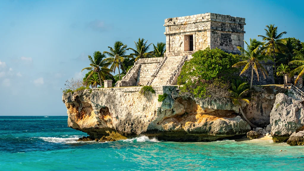
The stretch south to Tulum passes cenotes, eco-parks, and beach clubs. Tulum itself has the famous clifftop Maya ruins overlooking the Caribbean (entry 80 MXN / $4.60), plus a long beach road lined with bohemian hotels and restaurants. Tulum town (inland) is where locals eat – cheaper and more authentic than the beach zone.
The parking situation at Tulum ruins requires a word: the official lot charges 100 MXN ($5.71) and fills up by 09:30. Arrive at 08:00 for the ruins at opening before tour buses from Cancun arrive. The views from the cliff over the Caribbean are worth the early start.
Tulum → Valladolid via Coba (130 km, 2 hours)
Head inland to Coba, a Maya archaeological site where you can still climb the main pyramid (Nohoch Mul, 42 meters). The surrounding jungle is dense and the site is less crowded than Chichen Itza. Entry 80 MXN ($4.60). From Coba, continue to Valladolid, a colonial city with a beautiful central plaza, cenotes within walking distance (Cenote Zaci, 30 MXN / $1.71), and some of the best Yucatecan food on the peninsula.
The road from Coba to Valladolid (approximately 50 km on free road) passes through small Mayan villages. Slow down at each one – topes are unmarked and aggressive, and the villages are worth a look. The cochinita pibil (slow-roasted pork) sold from street stalls in these villages is better than anything you will find in Cancun restaurants.
Valladolid: why this stop is underrated
Most visitors treat Valladolid as a one-night stop between Cancun and Merida, which means they leave before discovering that the city has its own rhythm worth slowing down for. The Palacio Municipal on the main plaza lights up at dusk while locals walk laps around the square. The Cenote Zaci, within walking distance of the center, is an open-sky cenote in a cave that you enter down a stone staircase (30 MXN entry). Cenote Samula (10 km east) is more dramatic – suspended aerial roots hang down from the cave ceiling into green water. Allow two nights in Valladolid, not one.
Valladolid → Chichen Itza (42 km, 40 minutes)
The short drive west to Chichen Itza on the cuota highway. Arrive at opening (08:00) to beat the tour buses from Cancun, which arrive around 10:30. The Pyramid of Kukulkan is as impressive as advertised. Entry 614 MXN ($35) for foreigners. The site is large – allow 3-4 hours to see the main pyramid, the ball court (the largest in Mesoamerica), the Temple of Warriors, and the cenote. Bring water; the sun exposure is relentless.
Cenote Ik Kil: 3 km east of Chichen Itza, this famous cenote (entry 180 MXN / $10.30) is beautiful and extremely popular. Arrive before 10:00 or after 15:00 to avoid the worst tour bus overlap. The cenote is circular, 60 meters deep, with waterfalls and hanging vines – worth the stop despite the crowds.
Chichen Itza → Merida (120 km, 1.5 hours via cuota)
Continue west to Merida, the cultural capital of the Yucatan. This is a proper city – grand colonial architecture, excellent museums, a lively market (Lucas de Galvez), and a food scene that rivals Mexico City. Stay at least two nights. The paseo along Montejo Avenue is lined with mansions, and the Sunday street party (Domingo Meridano) fills the centro with food stalls, music, and local families. Merida is also the hottest city in Mexico – the 40-degree heat in summer is legendary. November to March is dramatically more comfortable.
Merida → Uxmal (80 km, 1 hour)
Drive south to Uxmal, the finest Maya archaeological site in the Yucatan for our money. The Pyramid of the Magician and the Governor’s Palace are architectural masterpieces, and the site is far less crowded than Chichen Itza. Entry 494 MXN ($28). Uxmal does not have a cenote for swimming after the visit, but the nearby Hacienda Uxmal has a pool open to non-guests for a fee – worth knowing after a morning of climbing stone ruins in Yucatan heat.
Ruta Puuc from Uxmal: If you have time, the Ruta Puuc continues south from Uxmal through four smaller archaeological sites – Kabah, Sayil, Xlapak, and Labna – before reaching the Loltun Caves (entry 95 MXN / $5.43, guided tour mandatory). The entire circuit from Uxmal is 60 km and takes 4-5 hours including stops. These sites are rarely crowded, the architecture (Puuc style, characterized by intricate stone mosaics) is distinctive, and you can drive the entire route in a compact car without issue.
Uxmal → Campeche (160 km, 2 hours)
Continue south to Campeche, a walled colonial city on the Gulf of Mexico. The restored centro historico is painted in pastels, the seafood is outstanding, and the atmosphere is more authentically Mexican than anywhere on the Caribbean coast. Campeche is the most underrated city on this circuit. There are almost no international tourists – the visitors are overwhelmingly Mexican – and the experience of wandering the bulwark walls, eating pan de cazon (shark tortilla lasagna), and watching locals go about their evening in the main plaza is worth the detour.
Campeche → Cancun via 180 cuota (450 km, 5 hours)
Return to Cancun via the cuota highway, or break the return with stops at Celestun (flamingos, 2 hours from Campeche) or Izamal (the yellow city, 1 hour from Merida).
Celestun detour: The Reserva de la Biosfera Ria Celestun hosts a large flamingo colony best seen from January to March. The boat tour from Celestun village (approximately 1,500-2,000 MXN / $85-114 per boat, shared among passengers) takes you through mangroves to the flamingo feeding grounds. The town also has excellent fresh fish restaurants on the beach. The drive from Merida to Celestun is 90 km (1.5 hours) through flat scrubland that suddenly opens to flamingo-pink lagoons.
Planning Tips
- 7 days minimum. This circuit is roughly 1,100 km of driving, but the stops need time. Two days in Merida, a day at Tulum, and time for cenotes and ruins means 7-10 days is ideal.
- Cuota vs. libre. Take the cuota for the long legs (Merida-Cancun, Campeche-Merida). Take the libre for short scenic stretches (Valladolid-Chichen Itza, Merida-Uxmal).
- Cenote strategy. There are thousands of cenotes in the Yucatan. The famous ones (Gran Cenote near Tulum, Cenote Ik Kil near Chichen Itza) are crowded and pricey. Ask locals for lesser-known cenotes – they exist within driving distance of every major stop.
- Fuel. Pemex stations are frequent on main routes. Fill up before entering rural stretches south of Valladolid or around Coba.
Fuel Stops on the Yucatan Circuit
| Segment | Distance Without Station | Risk Level | Advice |
|---|---|---|---|
| Coba to Valladolid | 50 km | Low | Fill in Tulum before heading inland |
| Uxmal to Campeche | 160 km | Low | Stations in Santa Elena (40 km from Uxmal) |
| Campeche to Merida via libre | 200 km | Medium | Fill in Campeche city |
| Izamal detour | Variable | Low | Izamal has a Pemex |
| Ruta Puuc circuit | 60 km loop | Low | Fill in Uxmal area before starting |
Riviera Maya Strip
For travelers with limited time, the 130 km stretch from Cancun to Tulum is the most accessible and rewarding short drive in Mexico. Flat, fast, well-maintained Highway 307 runs parallel to the coast, with cenotes, beaches, ruins, and eco-parks accessible via short turnoffs.
The Route
This is essentially the first leg of the Yucatan circuit (Cancun to Tulum), but treated as a standalone trip with more time for stops.
Day 1: Cancun → Playa del Carmen (65 km)
- Puerto Morelos snorkeling stop
- Cenote Route (Ruta de los Cenotes) near Puerto Morelos – a side road with 6-8 cenotes accessible from a single lane road (20-100 MXN entry each)
- Playa del Carmen for evening
Day 2: Playa del Carmen & Cozumel
- Morning ferry to Cozumel for snorkeling/diving (or rent a scooter and tour the island)
- Afternoon return, explore Playa
Day 3: Playa del Carmen → Tulum (65 km)
- Akumal Bay (snorkeling with sea turtles, 100-200 MXN for guided snorkel)
- Gran Cenote (200 MXN / $11.40 entry)
- Tulum ruins (morning visit, 80 MXN)
- Tulum beach zone afternoon
Day 4-5: Tulum base
- Sian Ka’an Biosphere Reserve (guided tour from Tulum, or self-drive the rough road)
- Cenote Dos Ojos (350 MXN / $20 for snorkeling)
- Laguna Bacalar (2 hours south – “Lake of Seven Colors,” genuinely spectacular)
Riviera Maya Hidden Stops
The stretch between Puerto Morelos and Playa del Carmen has a collection of less-publicized stops that reward exploration:
- Punta Maroma: Beach access 25 km south of Cancun, one of the finest beaches on the coast. Paid access through the resort, but worth it.
- Xcaret mouth (free beach): South of Xcaret eco-park, a free beach with excellent snorkeling. The eco-park itself charges USD 90+ per person – skip it in favor of real cenotes.
- Aktun-Chen cave: 28 km south of Playa del Carmen, a cave cenote with excellent stalactites and a small zoo. Entry 440 MXN ($25). Less crowded than the highway-adjacent cenotes.
Laguna Bacalar: The Underrated Extension
Two hours south of Tulum, Laguna Bacalar (the Lake of Seven Colors) is the most spectacular body of water in Mexico that most tourists have never heard of. The lake is 42 km long and runs from deep cobalt blue to turquoise to pale aquamarine depending on depth and light conditions. Cenotes feed it from below, maintaining visibility of 30+ meters in places. The town of Bacalar has waterfront restaurants, sailing trips, and none of the tourist pressure of Tulum.
The drive south from Tulum on Highway 307 to Bacalar is 150 km (about 1.5-2 hours on good libre road). It passes through small towns and flat scrubland that opens suddenly to the lake at the town entrance. Staying one night in Bacalar makes more sense than the day trip – the light on the lake at dawn is worth setting an alarm for.
From Bacalar, you are 40 km from Chetumal and the Belize border. For travelers with extra time, the Belize road trip (a different rental and different pages, but worth noting) begins here.
Planning Tips
- 3-5 days. This strip can be driven in a day but deserves 3-5 for proper exploration.
- Highway 307. Fast and easy. Single toll-free highway with good signage.
- Cenote budgeting. Entry fees add up. Budget 200-500 MXN ($11-29) per cenote per person. The smaller, locally run cenotes are cheaper (30-80 MXN) and often better.
Baja California: Tijuana to Cabo
The Baja Peninsula is 1,700 km of Pacific coast, desert, mountains, and isolation. This is the Mexico road trip for people who love driving itself – long stretches of empty highway through dramatic landscapes, with small towns providing fuel, tacos, and enough company to remind you that civilization exists. The Transpeninsular Highway (Highway 1) runs the full length of the peninsula, and while it is a proper two-lane highway with good surface, the distances between services can be long.
The Route (Highlights)
Tijuana → Ensenada (100 km, 1.5 hours)
- Scenic coastal cuota highway with Pacific views
- Ensenada: fish tacos at the fish market on Primera Street, wine tasting in Valle de Guadalupe (Mexico’s best wine region, 30 minutes inland)
- Valle de Guadalupe has 120+ wineries along a dusty valley road. The wine is legitimately world-class – the region produces Nebbiolo, Grenache, and Tempranillo that compete with Spanish counterparts at a fraction of the price
Ensenada → Guerrero Negro (700 km, 8-9 hours)
- Long desert drive through Baja’s central wilderness
- The landscape shifts from scrub to boulder field to cactus forest to salt flats
- Guerrero Negro: whale watching from January to March when gray whales enter the Ojo de Liebre lagoon to breed. The whales approach boats and allow themselves to be touched – one of the more extraordinary wildlife encounters in the Americas
Guerrero Negro → Loreto (500 km, 6 hours)
- Mulege: palm-lined oasis town with a mission church on a river bend. The contrast between the surrounding desert and the green oasis is jarring in the best way
- Loreto: colonial town, Sea of Cortez beaches, snorkeling with sea lions off Coronado Island (guided tour, 800-1,200 MXN per person)
Loreto → La Paz (360 km, 4 hours)
- La Paz: the “real” capital of Baja Sur, Malecon waterfront promenade, Balandra beach (frequently cited as Mexico’s most beautiful), swimming with whale sharks from October to March (tours 1,500-2,500 MXN per person)
- La Paz has a completely different atmosphere from Cabo – less resort development, more genuine Mexican city, better and cheaper food
La Paz → Cabo San Lucas (220 km, 2.5 hours)
- Todos Santos: artsy surf town, Hotel California (allegedly the one from the Eagles song – the hotel leans into it shamelessly, the margaritas are fine)
- Cabo: the famous arch (El Arco), resort zone, and nightlife. The arch is best seen from a glass-bottom boat (200-400 MXN)
Baja Distances and Service Gaps
| Segment | Distance | Drive Time | Fuel Gap Note |
|---|---|---|---|
| Tijuana to Ensenada | 100 km | 1.5 hours | No issues; services frequent |
| Ensenada to El Rosario | 245 km | 3 hours | Fill in Ensenada |
| El Rosario to Villa Jesus Maria | 210 km | 2.5 hours | Longest gap on Hwy 1 – fill at El Rosario |
| Villa Jesus Maria to Guerrero Negro | 135 km | 1.5 hours | Stations at both ends |
| Guerrero Negro to Santa Rosalia | 225 km | 2.5 hours | One station at halfway point |
| Santa Rosalia to Loreto | 130 km | 1.5 hours | No issues |
| Loreto to La Paz | 360 km | 4 hours | Stations in Ciudad Insurgentes and La Paz |
| La Paz to Cabo | 220 km | 2.5 hours | No issues |
The El Rosario rule: Fill your tank completely at El Rosario. The next guaranteed fuel is 210 km away. This is the longest service gap on the entire peninsula and has caught enough travelers off guard that it has its own entry in every Baja driving forum. In a standard compact car, 210 km is well within range from a full tank. In a truck or SUV with poor fuel economy, carry an extra 20 liters.
Planning Tips
- 7-14 days. The drive can be done in 3 days straight, but 7-14 allows for meaningful stops.
- Fuel planning. The biggest gap on Highway 1 is between El Rosario and Villa Jesús María – over 200 km with limited services. Fill up at El Rosario and carry an extra 20-30 liters if driving a large vehicle. Carry extra water regardless.
- Insurance. Mexican liability insurance is mandatory. Confirm coverage for Baja specifically – some US car insurance policies have a coverage zone that ends at the Baja border or within 25 miles of the US border.
- Fly-drive alternative. Fly into La Paz or Cabo and do the southern Baja loop (Cabo-La Paz-Loreto-Cabo, ~1,000 km) in 5-7 days. This is arguably the better trip – the southern Baja scenery is more varied and the distances are manageable.
Oaxaca Highlands and Coast
Oaxaca is Mexico for the experienced driver – mountain roads with switchbacks, dramatic elevation changes (from 1,500 meters in Oaxaca City to sea level in 200 km), and some of the most rewarding landscapes in the country. The food, the mezcal, the indigenous culture, and the Pacific coast beaches at Puerto Escondido and Huatulco make this arguably the most diverse single-state road trip in Mexico.
The Route
Mexico City → Oaxaca City (460 km, 5 hours via cuota)
- Modern toll highway through the Sierra Madre via Tehuacan
- Oaxaca City: colonial centro (a UNESCO World Heritage site), Monte Alban ruins on a hill overlooking the valley (entry 90 MXN / $5.14), mezcal tastings at in-city palenques from 50-200 MXN per flight, market food at the Mercado Benito Juarez and the newer Mercado 20 de Noviembre
Oaxaca City → Hierve el Agua (70 km, 2 hours)
- Petrified waterfalls and natural infinity pools at 2,000 meters. The “waterfalls” are mineral-rich springs that have calcified into stone formations over thousands of years, with pools at the top that hang over the valley
- Mountain road through Zapotec villages – slow going at 30-40 km/h through each settlement, but the villages themselves (San Marcos Tlapazola, San Lorenzo Albarradas) are worth stops
Oaxaca City → Puerto Escondido (260 km, 6-7 hours)
- The mountain descent via Highway 131 is slow, winding, and spectacular – 200 km of continuous switchbacks dropping 1,500 meters through cloud forest, coffee plantations, and pine-to-palm transitions
- Puerto Escondido: Mexico’s surf capital, Playa Zicatela is a world-class beach break with some of the heaviest shore-break waves in the Americas. Non-surfers should swim at Playa Manzanillo or Puerto Angelito, both calmer bays within walking distance
Puerto Escondido → Huatulco (110 km, 1.5 hours)
- Coastal highway with nine bays of Huatulco visible from the road as you approach
- Huatulco: the most resort-planned of the Oaxacan coast destinations, but with excellent snorkeling in the bays and a relaxed atmosphere that Puerto Escondido’s surf scene lacks
The Highway 131 Oaxaca-Puerto Escondido Experience
This 260 km drive deserves more than a bullet point. Highway 131 is the most dramatic continuous mountain descent in Mexico accessible by a standard rental car. The road climbs briefly from Oaxaca City before beginning a descent that barely stops until the Pacific.
At kilometer 80 (from Oaxaca), you are in cloud forest – pine trees, fog, and temperatures around 15 degrees C. By kilometer 150, the vegetation has shifted to coffee and cacao trees growing in the shade of the canopy. By kilometer 220, you are in tropical terrain, temperatures above 30 degrees C, and can smell the ocean. This is not metaphor. You drive through three climate zones in one day.
Practical notes for Highway 131:
- Drive only in daylight. The road has tight curves, no lighting, and no guardrails on many sections
- An intermediate or SUV-class car is recommended – a small economy car with limited power will struggle on the steeper uphill sections and the engine braking on descents may overheat the brakes
- Fill up in Oaxaca City before starting. Next reliable station is Sola de Vega (about 100 km) and then Puerto Escondido
- Morning fog on the upper sections can reduce visibility. If you depart at 06:00, you hit the fog; if you depart at 08:00, it is usually clear by then
Oaxaca Mezcal Country Side Trip
From Oaxaca City, a day loop through the mezcal villages takes you through the heartland of artisanal production:
- Santiago Matalan (45 km south, 1 hour): the “world capital of mezcal,” dozens of family palenques with direct-from-producer prices. Tours of the agave roasting pits and distillation process are free or low-cost
- Miahuatlan de Porfirio Diaz: a working market town with a mezcal market on Sundays
- Return via Cuilapam and Monte Alban for the ruins at sunset
Mezcal warning: if your co-pilot is the designated taster for the day, plan the route accordingly. The Oaxacan hospitality involves offering samples at every stop, and there are many stops.
Planning Tips
- 5-7 days minimum. Oaxaca City alone deserves 2-3 days.
- Mountain driving. The Oaxaca-Puerto Escondido road is demanding – tight curves, steep grades, fog possible in the morning. Drive during daylight only. An intermediate or SUV-class car is recommended; a small economy hatchback will struggle on the steeper sections.
- Mezcal warning. Oaxaca has dozens of mezcal distilleries (palenques) open for visits. Designate a driver.
Building Your Itinerary
1 Week, Yucatan Focus:
- Days 1-2: Cancun to Tulum (cenotes, ruins, beach)
- Days 3-4: Tulum to Valladolid (Coba, cenotes, colonial city)
- Day 5: Chichen Itza to Merida
- Days 6-7: Merida (city, Uxmal day trip), return to Cancun
2 Weeks, Mixed:
- Week 1: Yucatan Grand Circuit (as above)
- Week 2: Fly to Oaxaca or La Paz, rent second car, explore
3-4 Days, Riviera Maya:
- The strip from Cancun to Tulum with cenotes and beach stops
10 Days, Baja Focus (fly into La Paz):
- Days 1-2: La Paz base (Balandra beach, whale shark swim)
- Days 3-4: Loreto (colonial town, sea lion snorkeling)
- Days 5-6: Return south via inland route, Todos Santos
- Days 7-8: Los Cabos area
- Days 9-10: Return to La Paz for flight
12 Days, Oaxaca + Yucatan (fly in different cities):
- Days 1-4: Fly to Mexico City, rent car, drive to Oaxaca, explore mezcal country and Monte Alban
- Day 5: Drive Mexico City to Oaxaca return, fly Oaxaca to Cancun
- Days 6-12: Yucatan circuit from Cancun
Practical Car Choices by Route
| Route | Minimum Recommended | Why |
|---|---|---|
| Yucatan Grand Circuit | Compact | Flat roads, good surfaces throughout |
| Riviera Maya Strip | Economy | Easy driving, no mountain sections |
| Baja California | Compact or Intermediate | Long distances, better fuel range |
| Oaxaca Highlands | Intermediate or small SUV | Mountain grades on Hwy 131 |
| Full Mexico circuit | Intermediate or Compact | Versatility for mixed terrain |
For driving rules and safety tips, see our driving guide. Budget details are in our costs guide. Airport rental advice is in our airport guide.