Best Road Trips in Iceland
We had read that Iceland was beautiful before we drove the Ring Road. We had seen the photos, watched the documentaries, scrolled through countless Instagram posts. None of it prepared us for the reality. Within the first 100 km, we had pulled over four times – once for a waterfall we could see from the road, once for a black sand beach that appeared around a bend, once because a glacier was doing something impossible with the light, and once because we genuinely needed to sit quietly and process what we were looking at. By the end of the trip, we had stopped counting the pull-overs. Iceland does not do subtle.
The country rewards two things above all else: flexibility and time. Plan your route with care, then abandon the schedule whenever Iceland offers you something better than what you had planned.
Route 1: The Ring Road (1,322 km, 7-10 days)
The Ring Road (Route 1) is not just the best road trip in Iceland – it is one of the best on the planet. It circles the entire island, passing through almost every type of landscape the country offers: waterfalls, glaciers, lava fields, volcanic craters, fjords, whale-watching towns, geothermal areas, and black sand beaches. Every section delivers something completely different from the last.
Itinerary (clockwise from Reykjavik):
Reykjavik – Vik (1-2 nights) – Jokulsarlon/Hofn (1-2 nights) – Egilsstadir (1 night) – Husavik/Myvatn (2 nights) – Akureyri (1 night) – Blonduos/Hvammstangi (1 night) – Reykjavik
Highlights by section:
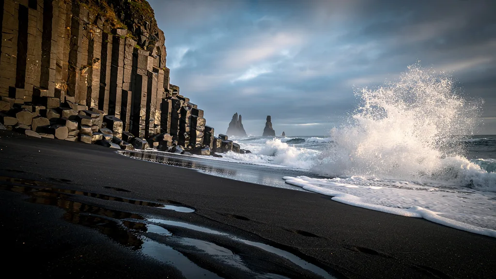
South Coast (Reykjavik to Vik, 186 km): Seljalandsfoss (walk behind the waterfall on a wooden path – wet and extraordinary), Skogafoss (climb the 527 steps to the top for views of the waterfall and out to sea), the abandoned DC-3 plane wreck on Solheimasandur (a 2 km walk each way from the parking lot, completely surreal), and Reynisfjara black sand beach with its basalt column stacks called Reynisdrangar. This is the most touristy section and for good reason – the density of world-class sights per kilometer is absurd. Build in extra time; it always takes longer than Google Maps suggests.
Glacier Coast (Vik to Hofn, 270 km): Skaftafell Nature Reserve in Vatnajokull National Park (hike to Svartifoss, a waterfall framed by hexagonal basalt columns – 90 minutes return, worth every step), Jokulsarlon glacier lagoon (icebergs floating in surreal blue water with seals playing between them), and the Diamond Beach directly across the road where chunks of glacial ice wash up on jet-black sand and sparkle in the sun. Jokulsarlon alone is worth the entire trip. Budget at least 2-3 hours here and watch the light change on the ice.
Eastern Fjords (Hofn to Egilsstadir, 260 km): The quietest and most underrated section. Narrow roads wind through fjord after fjord, passing fishing villages, waterfalls, and a coastline that feels more like Norway than Iceland. The town of Djupivogur has the Egg sculpture on the harbor (38 stone eggs representing local bird species, unexpectedly moving). Take your time – this section rewards slow driving and stopping at small cafes.
Northern Highlights (Egilsstadir to Akureyri, 265 km via Myvatn): Dettifoss, Europe’s most powerful waterfall (take the east road 864 for the better and less crowded viewpoint – it is gravel but manageable), Myvatn lake and its volcanic surroundings (pseudo-craters that look like the moon, lava formations called Dimmuborgir that look like something from fantasy literature, and the Myvatn Nature Baths for a soak), Godafoss waterfall (perfectly photogenic at any time of day), and Husavik for whale watching (the best whale watching in Iceland, with a whale museum that is genuinely excellent). This section has the highest concentration of geothermal activity outside Reykjavik.
Northwest (Akureyri to Reykjavik, 380 km): The least dramatic section visually, but the seal colonies at Hvammstangi (accessible on short walks from the road), the historic turf house farm at Glaumbaer (a genuine 19th-century Icelandic farm preserved in full), and the vast austere emptiness of the Snaefellsnes route back (if you add the peninsula – highly recommended) have their own profound beauty. The Vestfjords viewpoints near Hvammstangi are spectacular at the right time of day.
Practical details:
| Section | Distance | Driving Time | Key Stops |
|---|---|---|---|
| Reykjavik to Vik | 186 km | 2.5 hours base | Seljalandsfoss, Skogafoss, Reynisfjara |
| Vik to Hofn | 270 km | 4 hours base | Skaftafell, Jokulsarlon, Diamond Beach |
| Hofn to Egilsstadir | 260 km | 4.5 hours base | Eastern fjords, Djupivogur |
| Egilsstadir to Akureyri (via Myvatn) | 265 km | 4 hours base | Dettifoss, Myvatn, Godafoss |
| Akureyri to Reykjavik | 380 km | 4.5 hours base | Glaumbaer, seal colonies |
Note: “driving time” reflects time actually moving. Add 30-60 minutes per major stop for a realistic daily schedule.
Vehicle: Standard 2WD is fine for the entire Ring Road in summer. 4x4 recommended in shoulder season and if adding F-road detours. The gravel section of Route 864 to Dettifoss is manageable in 2WD at low speed.
Best season: June-August for full access and midnight sun. September for fewer crowds and northern lights potential after dark.
Accommodation strategy: Book Ring Road accommodation 2-3 months ahead for summer. Guesthouses in Vik, Hofn, Egilsstadir, and Myvatn sell out. Camping is available at most locations (about 2,000-3,000 ISK / EUR 14-20 per person per night).
Route 2: The Golden Circle (300 km loop, 1 day)
The Golden Circle is Iceland’s most popular day trip for a reason: three extraordinary natural sites packed into a manageable loop that starts and ends in Reykjavik. It is perfect for a first day of driving to orient yourself before tackling longer routes, and it delivers more in 6-8 hours than most countries offer in a week.
Itinerary:
Reykjavik – Thingvellir National Park – Geysir geothermal area – Gullfoss waterfall – optional: Secret Lagoon at Fludir or Kerid crater – Reykjavik
Key stops:
Thingvellir National Park is where the North American and Eurasian tectonic plates pull apart, creating a visible rift valley of extraordinary geological significance. It is also where Iceland’s parliament (Althing) was founded in 930 AD, making it one of the world’s oldest legislative sites. The walk along the Almannagjá rift – literally walking between two continental plates – is surreal and affecting. The Silfra fissure here is famous for diving and snorkeling in water so clear it has visibility to 100 meters. Parking fee: 750 ISK (EUR 5).
Geysir/Strokkur is the geothermal area where Strokkur erupts every 5-10 minutes, shooting boiling water 20-30 meters into the air with a distinctive belch-and-explosion pattern that never gets old despite watching it 15 times. The original Great Geysir, which gave its name to all geysers worldwide, is mostly dormant now but occasionally erupts. The surrounding area has bubbling mud pools, fumaroles, and multicolored hot spring deposits. Free entry, free parking, good cafe.
Gullfoss is a massive two-tiered waterfall where the Hvita river drops 32 meters total into a narrow canyon. In full flow (summer), the spray reaches the viewing platform and the roar fills the valley. The full-flow season (June-August) is when the glacial melt swells the river to its most dramatic. Free entry, free parking, the best waterfall cafe in Iceland (Gullfoss Cafe).
Optional add-ons:
The Secret Lagoon at Fludir (25 km from the Golden Circle loop) is Iceland’s oldest swimming pool, with naturally heated geothermal water at 38-40 C and a small geyser on the property. Entry: 3,200 ISK (EUR 22). Quieter and more authentic than the Blue Lagoon.
Kerid Crater is a 6,500-year-old volcanic crater lake with vivid green water at the bottom. Entry: 700 ISK (EUR 5). The walk around the rim takes 15 minutes and provides good views.
Practical details:
| Section | Distance | Driving Time |
|---|---|---|
| Reykjavik to Thingvellir | 47 km | 45 minutes |
| Thingvellir to Geysir | 60 km | 1 hour |
| Geysir to Gullfoss | 10 km | 10 minutes |
| Gullfoss to Fludir (optional) | 30 km | 35 minutes |
| Fludir to Reykjavik | 100 km | 1.5 hours |
| Gullfoss to Reykjavik (direct) | 120 km | 1.5 hours |
Vehicle: Any 2WD car works. The entire route is on paved roads.
Best season: Year-round. In winter, the roads are usually cleared but may be icy – check road.is before departure. Winter Golden Circle visits have the advantage of snow-covered landscapes and potential northern lights.
Route 3: Snaefellsnes Peninsula (200 km, 2-3 days)
Snaefellsnes is often called “Iceland in Miniature” because it packs glaciers, volcanoes, lava fields, sea cliffs, fishing villages, and black beaches into a single peninsula jutting west into the Atlantic. It is the best route for travelers with limited time who want more than the Golden Circle but less commitment than the full Ring Road.
Itinerary:
Reykjavik – Borgarnes – Stykkisholmur (1 night) – Snaefellsjokull National Park – Arnarstapi – Budir – Reykjavik
Key stops:
Kirkjufell near Grundarfjordur is Iceland’s most photographed mountain – a distinctive isolated cone shape with the triple Kirkjufellfoss waterfall in front of it. Best photographed from the small parking area on the west side of the mountain, particularly in the hour before sunset. Northern lights with Kirkjufell in the foreground are among the most iconic Iceland images.
Snaefellsjokull glacier caps a volcano at the western tip of the peninsula. It was the glacier Jules Verne used as the entrance to the center of the earth in his 1864 novel. It is also one of Iceland’s “sacred mountains” with various mystical associations. On clear days, you can see the glacier from Reykjavik across the bay – about 120 km away. The national park around the glacier has well-marked walking trails across lava fields.
Arnarstapi to Hellnar coastal walk is a 2.5 km path along dramatic sea cliffs with basalt formations, sea arches, bird colonies (including Arctic tern, which will dive-bomb you in June – carry a stick), and stunning views of the glacier above. Allow 1.5-2 hours for the return walk. The path is well-maintained and suitable for regular walking shoes.
Budir has a famous black wooden church (Budakirkja) sitting alone in an ancient lava field overlooking the sea, with the glacier visible in the background on clear days. One of the most photogenic scenes in Iceland. Hauntingly beautiful at any time of year, particularly in misty conditions.
Djupalonssandur (Black Lava Pearl Beach) has extraordinary black pebbles worn by the sea into smooth spheres, the remains of a British fishing trawler wrecked in 1948, and lifting stones used historically to test sailors’ strength. A short but dramatic coastal walk.
Practical details:
| Section | Distance | Driving Time |
|---|---|---|
| Reykjavik to Stykkisholmur | 170 km | 2.5 hours |
| Stykkisholmur to Arnarstapi (southern road) | 90 km | 2 hours (with stops) |
| Arnarstapi to Reykjavik | 190 km | 2.5 hours |
Vehicle: 2WD is sufficient for the paved road around the peninsula. Some gravel sections near Djupalonssandur beach are manageable but require slow driving.
Best season: May-September. The peninsula is fully exposed to Atlantic weather, and winter conditions can include severe storms, ice, and road closures. Spring and autumn are excellent for fewer crowds and potentially dramatic light.
Route 4: The Highlands – Landmannalaugar (F-road, 190 km one way, 2-3 days)
This is the route for experienced drivers with a proper 4x4. Landmannalaugar is a geothermal area in the southern highlands famous for its multicolored rhyolite mountains – striped in red, green, yellow, blue, orange, and purple like a geological paint palette gone rogue. Getting there involves river crossings, rough highland tracks, and some of the most remote driving in Iceland.
Itinerary:
Reykjavik – Hella – F225/F208 to Landmannalaugar – hike and soak in hot springs – return via F208 to Hrauneyjar – Route 1
Key stops:
Landmannalaugar itself is a natural hot spring at the base of rainbow-striped mountains, accessible to anyone with an appropriate vehicle. The area is simultaneously a trailhead for the world-famous Laugavegur multi-day trek and a day destination for shorter hikes. A soak in the 38 C natural hot spring after a hike across the multicolored rhyolite slopes is one of those experiences that justifies an entire trip to Iceland.
Laugavegur Trek: The 55 km trek from Landmannalaugar to Thorsmork is widely considered one of the world’s great multi-day hikes. Four days, extraordinary landscapes, and huts for accommodation. Booking the huts through Ferdalag (the Iceland hiking association) is essential for summer – they fill months in advance.
River crossings on the F-roads: The F225 and F208 routes include several river fords. Water depth varies with rainfall and glacial snowmelt, sometimes dramatically within a single day. Check conditions at road.is before departure. Travel in convoy with other 4x4s when possible – if someone gets stuck, having help immediately is far better than calling for it. The depth markers at ford crossings are reliable; if the water covers the marker, do not cross.
Practical details:
| Section | Distance | Driving Time |
|---|---|---|
| Reykjavik to Hella (Route 1) | 95 km | 1.5 hours |
| Hella to Landmannalaugar (F-roads) | 95 km | 3-4 hours |
| Return to Route 1 (via F208) | 100 km | 3 hours |
Vehicle: 4x4 with high clearance (Dacia Duster minimum, Toyota RAV4 preferred, Land Cruiser ideal) is mandatory. No exceptions whatsoever. Rental insurance specifically for F-roads requires the appropriate coverage – verify with your agency.
Best season: Late June to early September. F-roads are closed outside this window. Check safetravel.is and road.is on the morning of departure.
Route 5: The Westfjords (500 km, 4-6 days)
The Westfjords are Iceland’s largest peninsula and its most remote region. Very few visitors make it here, which is both the problem (infrastructure is basic) and the appeal (you will have dramatic landscapes almost entirely to yourself). The driving is more challenging than the Ring Road, the roads include significant gravel sections, and the area requires a genuine spirit of adventure. The reward is Iceland as it was before tourism.
Itinerary:
Borgarnes – Holmavik (1 night) – Dynjandi waterfall – Isafjordur (2 nights) – Latrabjarg bird cliffs – Patreksfjordur – back to Borgarnes
Key stops:
Dynjandi (also called Fjallfoss) is arguably Iceland’s most beautiful waterfall – a wide tiered cascade dropping 100 meters in stages, with six smaller falls below. Most visitors see it only briefly; we recommend hiking the 20 minutes to the base of the main fall and sitting there for an hour. Very few people do this.
Isafjordur is the “capital” of the Westfjords, a small town of 3,000 people surrounded by fjords that somehow contains excellent restaurants, a music festival, and a sense of community that larger Icelandic towns have lost. The Westfjords Heritage Museum in nearby Bolungarvik is fascinating.
Latrabjarg bird cliffs are the westernmost point of Iceland and Europe, and the largest seabird colony in Europe. Puffins, razorbills, fulmars, and guillemots nest in their millions in the vertical cliffs. In June and July, puffins sit at the cliff edge within arm’s reach – they appear to be completely unimpressed by humans, which makes photography very easy.
Practical details:
| Section | Distance | Driving Time | Road Quality |
|---|---|---|---|
| Borgarnes to Holmavik | 200 km | 3 hours | Mix paved/gravel |
| Holmavik to Dynjandi | 150 km | 3 hours | Gravel, dramatic |
| Dynjandi to Isafjordur | 80 km | 2 hours | Mix |
| Isafjordur to Latrabjarg | 180 km | 4 hours | Gravel, remote |
| Latrabjarg return | 400 km | 7-8 hours | Return same route or via south |
Vehicle: 2WD is technically possible in summer dry conditions but 4x4 is strongly recommended for the Westfjords gravel roads, many of which have steep sections and no guardrails.
Route Comparison Table
| Route | Distance | Duration | Difficulty | Best Season | Vehicle | Highlights |
|---|---|---|---|---|---|---|
| Ring Road | 1,322 km | 7-10 days | Easy-Moderate | Jun-Aug | 2WD or 4x4 | Everything |
| Golden Circle | 300 km | 1 day | Easy | Year-round | Any 2WD | Thingvellir, Geysir, Gullfoss |
| Snaefellsnes | 200 km | 2-3 days | Easy | May-Sep | 2WD | Kirkjufell, glacier, Budir |
| Landmannalaugar | 190 km one way | 2-3 days | Difficult | Late Jun-Sep | 4x4 only | Rainbow mountains, hot springs |
| Westfjords | 500 km | 4-6 days | Moderate-Hard | Jun-Aug | 4x4 recommended | Dynjandi, puffins, solitude |
Planning Your Road Trip
Which route for first-timers? The Ring Road with the Golden Circle as a warm-up on day one. Seven days minimum; ten is more comfortable. Drive clockwise to hit the south coast highlights first while you are fresh and have maximum time for the most photogenic stops.
The 2WD vs 4x4 decision: If you are sticking to the Ring Road, Golden Circle, and Snaefellsnes, a 2WD compact car is perfectly adequate and significantly cheaper – often EUR 30-80 per day less than a 4x4. On a 10-day trip, that is EUR 300-800 saved. Only rent a 4x4 if you genuinely plan to use it on F-roads or are driving in winter.
Accommodation: Book early for summer. Iceland’s lodging capacity is limited, especially in the north and east. Guesthouses and farm stays along the Ring Road fill up weeks in advance for July and August. Camping is available at designated campgrounds (about 2,000-3,000 ISK / EUR 14-20 per person per night) and many travelers combine campervans with the Ring Road for budget savings and maximum flexibility.
Weather checking: Check vedur.is (weather) and road.is (road conditions) every morning without fail. Icelandic weather changes from sunshine to horizontal rain within 30 minutes with no irony or warning. Carry layers, rain gear, and patience. The conditions that close roads in Iceland are genuinely dangerous.
Fuel planning: Mark fuel stations on your map or GPS before departure, especially for the north and east sections of the Ring Road. Never pass a station with less than half a tank. On F-roads, fill up at the last station on Route 1.
The one-stop rule: At every stop in Iceland – every waterfall, beach, viewpoint, hot spring – you will think “this is the most beautiful thing I have seen.” And then the next stop will top it. Do not rush. Build in buffer days for weather delays and spontaneous detours. The most memorable moments of Iceland road trips are usually the unplanned ones.
Route 6: The South Coast Concentrated (186 km, 1-2 Days)
If time is the main constraint and you cannot commit to the Ring Road, the South Coast drive from Reykjavik to Vik is Iceland’s highest-concentration-of-wonders route. In 186 km, you encounter more dramatic landscape per kilometer than almost anywhere else on the planet.
The full sequence of stops:
| Stop | Distance from Reykjavik | Time at Stop |
|---|---|---|
| Seljalandsfoss waterfall | 120 km | 45-60 min |
| Gljufrabui hidden waterfall | 1 km from Seljalandsfoss | 20 min |
| Skogafoss waterfall | 150 km | 45-60 min |
| Solheimasandur plane wreck | 165 km (+ 2 km walk each way) | 1.5-2 hours |
| Dyrholaey arch and viewpoint | 178 km | 30 min |
| Reynisfjara black sand beach | 183 km | 45-60 min |
| Vik village | 186 km | 20 min |
Seljalandsfoss: The waterfall with the famous path behind it — you walk through the spray behind the curtain of water on a wooden boardwalk. Wet. Extremely wet. Bring waterproof gear or accept the consequence. The path closes in icy conditions in winter. Best light: late afternoon when the sun hits the falls from the west.
Gljufrabui: 300 meters from Seljalandsfoss, completely overlooked by most visitors. You wade through a shallow stream into a narrow canyon to find a 40-meter waterfall hidden inside a cave. The inside is dramatic and the sound of water in the enclosed space is extraordinary. Waterproof shoes mandatory.
The plane wreck: A 1973 US Navy DC-3 abandoned on the black sand beach after an emergency landing (no fatalities). Now one of Iceland’s most photographed subjects. The 2 km walk each way on soft black sand is tiring in cold or windy weather; allow 1.5-2 hours total. Dress warmly and walk into the wind first so the return is easier.
The Midnight Sun and Night Driving
Summer (June-July): Iceland has near-24-hour daylight from approximately June 15 through July 15. The “golden hour” lasts for hours, not minutes. There is no night driving because there is no night. Stopping at 11 PM for a waterfall in full evening light feels entirely normal. The lack of darkness can confuse your sleep schedule (bring a sleep mask for guesthouse sleeping).
Spring and Autumn: The light becomes dramatic as the sun stays low on the horizon for extended periods. Golden hour effects that last 2-3 hours make roadside photography extraordinary in May and September.
Northern Lights Window: September through March is aurora season. Viewing requires darkness and clear skies. Check vedur.is for aurora alerts and cloud cover. Driving the Ring Road in late September offers the best compromise: summer road access still largely available, darkness returning, aurora possibility from 9 PM onward.
Timing Your Stops: Crowds and Light
The south coast in July and August brings visitor numbers that change the experience at the most popular sites. Seljalandsfoss, Reynisfjara, and the Jokulsarlon lagoon can be crowded from 10 AM to 6 PM. Arriving before 9 AM or after 7 PM changes the experience dramatically — and with 24-hour summer daylight, a 9 PM visit is in full golden-hour light.
| Site | Best Time | Worst Time | Notes |
|---|---|---|---|
| Seljalandsfoss | Before 9 AM or after 7 PM | 11 AM-4 PM | Path behind waterfall; morning light better |
| Reynisfjara | Before 9 AM | 11 AM-5 PM | Sunrise on black sand; ocean safety awareness |
| Jokulsarlon | Any clear time | Overcast midday | Light on icebergs: morning or golden hour |
| Geysir | After 5 PM | 11 AM-3 PM | Strokkur erupts regardless; crowd-free evenings |
| Thingvellir | Before 9 AM or after 6 PM | 10 AM-3 PM | Rift walk is peaceful early morning |
Multi-Week Itinerary: Ring Road + Snaefellsnes (14 Days)
For two weeks with maximum coverage:
| Day | Start → End | Drive | Highlights |
|---|---|---|---|
| 1 | Keflavik → Reykjavik | 50 km | City, Laugavegur street |
| 2 | Reykjavik → Vik | 186 km | Seljalandsfoss, Skogafoss, plane wreck |
| 3 | Vik → Hofn | 200 km | Skaftafell, Jokulsarlon |
| 4 | Hofn day trip | 60 km | Glacier hike or kayaking on the lagoon |
| 5 | Hofn → Egilsstadir | 260 km | East fjords slow drive, Djupivogur |
| 6 | Egilsstadir → Myvatn | 165 km | Dettifoss, Myvatn |
| 7 | Myvatn day | Local | Lava formations, Myvatn Nature Baths |
| 8 | Myvatn → Akureyri | 100 km | Husavik whale watching |
| 9 | Akureyri → Blonduos | 180 km | Glaumbaer turf farm, seal colonies |
| 10 | Blonduos → Borgarnes | 170 km | Hvammstangi seals, Borg a Myrum saga farm |
| 11 | Borgarnes → Snaefellsnes west | 130 km | Kirkjufell, Grundarfjordur |
| 12 | Snaefellsnes peninsula | 100 km | Glacier, Arnarstapi, Budir church |
| 13 | Snaefellsnes → Golden Circle | 200 km | Thingvellir, Geysir, Gullfoss |
| 14 | Golden Circle → Keflavik | 120 km | Return via Selfoss |
Total: approximately 2,100 km, averaging 150 km per driving day — entirely achievable given Iceland’s conditions and the stop-heavy nature of any Iceland drive.
For driving rules and conditions, see our Iceland driving guide. For pickup logistics, check the airport rental page. For a full budget breakdown, see our costs and tips guide. For road trip planning beyond Iceland, our tips section covers general self-drive advice.