Best Road Trips in Romania
We reached the summit of the Transfagarasan at 2,042 meters on a September morning when the clouds sat exactly at the pass elevation. We drove into white, saw nothing for thirty seconds, and then burst through the other side into sunshine with the Balea Lake glittering below and the entire Fagaras ridge stretching to the east. The sensation was like emerging from a tunnel into a painting. We pulled over and just looked at it for ten minutes. Behind us, the road – a ribbon of switchbacks descending into the cloud layer we had just escaped – looked impossible. We had just driven up it.
Romania has two of the most famous driving roads in Europe and several others that would be headline attractions in any other country. The Carpathian Mountains arc through the center of the country like a geological parenthesis, and the roads that cross them range from world-famous engineering marvels to quiet county roads through forests where you might not see another car for an hour.
Route Overview
| Route | Distance | Driving Time | Best Season | Highlights |
|---|---|---|---|---|
| Transfagarasan Highway | 90 km | 3-4 hours | Late June-October | Highest road in Romania, switchbacks, Balea Lake |
| Transalpina | 148 km | 4-5 hours | June-October | Highest altitude road, alpine meadows |
| Transylvania Towns Loop | 450 km | 5-7 hours driving | Year-round | Brasov, Sibiu, Sighisoara, fortified churches |
| Bucovina Painted Monasteries | 200 km | 3-4 hours driving | May-October | UNESCO monasteries, pastoral villages |
| Danube Delta and Dobrogea | 350 km | 5-6 hours driving | April-October | Delta wetlands, ancient ruins, coastal cliffs |
Route 1: The Transfagarasan Highway (DN7C)
| Distance: 90 km (Curtea de Arges to Cartisoara) | Time: 3-4 hours | Difficulty: Moderate-Challenging | Season: Late June through late October |
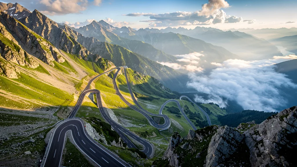
The Transfagarasan was built in the 1970s by Ceausescu as a military road, ostensibly so Romanian forces could cross the Carpathians quickly in case of a Soviet invasion from Transylvania. The result is one of the most dramatic mountain highways ever constructed – a road that climbs from 500 meters to 2,042 meters through dense forest and then bare alpine terrain, with hairpin turns, tunnels, and a 900-meter descent on the northern side.
Southern approach (from Curtea de Arges):
| Segment | Distance | Highlights |
|---|---|---|
| Curtea de Arges to Vidraru Dam | 35 km | Forest road, Vidraru reservoir (massive hydroelectric dam) |
| Vidraru Dam to tree line | 15 km | Steep switchbacks through beech forest |
| Tree line to Balea Cascada | 10 km | Alpine terrain, waterfalls, exposed switchbacks |
| Balea Cascada to Balea Lac (summit tunnel) | 5 km | The famous switchback section, tunnel at 2,042 m |
Northern descent (to Cartisoara/Sibiu):
| Segment | Distance | Highlights |
|---|---|---|
| Balea Lac to Balea Cascada (north side) | 8 km | Cable car station, alpine views |
| Balea Cascada to Cartisoara | 17 km | Forest descent, wider road, Transylvanian valley views |
The famous switchbacks: The southern ascent above Vidraru Dam contains the iconic section – a series of tight switchbacks climbing the bare mountainside with no guardrails on the outside. This is the section that was featured on Top Gear. It is genuinely thrilling to drive, but it requires attention. The road is narrow, oncoming traffic appears on the hairpins, and tourist cars frequently stop in the road for photos.
Complete Transfagarasan stops table:
| Stop | Km from Start | Time Needed | Notes |
|---|---|---|---|
| Curtea de Arges (start) | 0 km | 30 min | Medieval monastery, fuel station |
| Vidraru Dam and Lake | 35 km | 30-45 min | Massive hydroelectric dam, viewpoints |
| Lower switchbacks (through forest) | 45-55 km | Driving through | Beech forest, waterfalls |
| Balea Cascada (lower viewpoint) | 70 km | 30 min | Waterfall viewpoint, cafes, souvenir stalls |
| Upper switchbacks (the famous section) | 75-82 km | Driving through | The Top Gear switchbacks, above tree line |
| Balea Lake (summit, 2,042 m) | 82 km | 1 hour | Chalet, glacier lake, views, summit tunnel |
| Northern descent to Cartisoara | 90 km | Driving through | Wider road, forest, Transylvanian views |
Driving tips:
- Drive from south to north for the best experience – the famous switchbacks on the southern side are the main event
- Start early to avoid tourist traffic (before 8 AM in July-August) and for the best light on the summit area
- The summit area (Balea Lake) has a chalet with cafe, a small market, and toilets – good for a coffee break and view appreciation
- Weather changes rapidly above 1,800 meters. Bring warm layers even in summer – the temperature at the summit is 10-15 degrees cooler than Curtea de Arges
- Avoid weekends in July-August when the road becomes a slow procession of tourist vehicles with frequent stops for photographs in the roadway
- Check CNAIR (Romanian road authority, cnair.gov.ro) for current opening/closing dates – the road opens late June and closes late October
Route 2: The Transalpina (DN67C)
| Distance: 148 km (Novaci to Sebes) | Time: 4-5 hours | Difficulty: Moderate | Season: June through October |
The Transalpina is Romania’s other great mountain road, and in many ways it is the more rewarding drive. It reaches a higher altitude than the Transfagarasan (2,145 meters vs. 2,042 meters), passes through more varied alpine scenery, and sees far less traffic. The downside is less dramatic engineering – fewer switchbacks, more long sweeping curves – but the views are arguably better.
The route: From Novaci in the south (Oltenia side), the road climbs through Ranca ski resort and over the Urdele Pass at 2,145 meters before descending through the Jiu Valley to Sebes in Transylvania. The road is wider and less technical than the Transfagarasan, making it more relaxing to drive.
| Segment | Distance | Highlights |
|---|---|---|
| Novaci to Ranca | 30 km | Forest climb, small ski resort |
| Ranca to Urdele Pass | 20 km | Alpine meadows, panoramic views, highest point |
| Urdele Pass to Obarsia Lotrului | 35 km | High plateau driving, shepherds, flocks |
| Obarsia Lotrului to Sebes | 63 km | Descent through Jiu Valley, forest |
Why we prefer it to the Transfagarasan (sometimes): The Transalpina has something the Transfagarasan lacks: solitude. On a weekday in September, you can drive the alpine section for 30 minutes without seeing another car. The high plateau between Ranca and Obarsia Lotrului feels genuinely remote – shepherd huts, alpine meadows, wild horses grazing at 2,100 meters, and nothing else audible except wind. The Transfagarasan, especially in peak season, can feel like a slow-moving parking lot at the summit. If you want the mountain experience without the tourist volume, Transalpina delivers it.
Complete Transalpina stops table:
| Stop | Km from Start | Time Needed | Notes |
|---|---|---|---|
| Novaci (start) | 0 km | 20 min | Fuel station, last before the pass |
| Ranca ski resort | 30 km | 15 min | Small resort, cafes, first mountain views |
| Urdele Pass (2,145 m) | 50 km | 30 min | Highest point, panoramic views, wind |
| High plateau section | 50-85 km | Driving through | Most spectacular, minimal traffic |
| Obarsia Lotrului | 85 km | 15 min | Mountain junction, chalet |
| Petrosani descent | 100-148 km | Driving through | Industrial town, exit to Sebes |
Practical tips:
- Combine with the Transfagarasan for the ultimate Romanian mountain driving week – they are 3 hours apart by road
- The road surface is rougher than the Transfagarasan in places – potholes are possible in the lower sections
- No fuel available between Novaci and Sebes (148 km). Fill up completely in Novaci before starting
- The southern approach from Novaci offers the best scenery – start here if doing the pass one way
- A Dacia Duster or similar SUV handles the rougher sections more comfortably than a small hatchback
Route 3: The Transylvania Towns Loop
| Distance: 450 km (loop from Brasov) | Time: 5-7 hours of driving over 3-5 days | Difficulty: Easy | Season: Year-round |
This is the classic Transylvanian itinerary: a loop connecting the region’s medieval Saxon towns, fortified churches, and Carpathian scenery. Unlike the mountain passes, this route is drivable year-round and works at a leisurely pace with overnight stops in each town.
The route: Brasov - Sighisoara - Sibiu - Bran/Rasnov - Brasov
| Town | Distance from Previous | Highlights | Recommended Stay |
|---|---|---|---|
| Brasov | Start | Black Church, Council Square, Tampa Mountain | 1-2 nights |
| Sighisoara | 120 km (2 hr) | Citadel, Clock Tower, Dracula’s birthplace | 1 night |
| Sibiu | 95 km (1.5 hr) | Grand Square, Brukenthal Museum, Bridge of Lies | 1-2 nights |
| Bran | 170 km (3 hr via Transfagarasan or 2 hr direct) | Bran Castle (“Dracula’s Castle”), Rasnov Citadel | Day trip from Brasov |
| Brasov | 30 km (40 min) | Return to start | - |
Fortified churches detour: Between Sighisoara and Sibiu, the landscape is dotted with Saxon fortified churches – UNESCO-listed medieval churches surrounded by defensive walls built in the 14th and 15th centuries when the villages needed protection from Ottoman raids. The Saxons walled their churches and used them as fortresses. The result is extraordinarily atmospheric: small villages, ancient defensive towers, and churches that have been in continuous use since the 1300s. The villages of Biertan (UNESCO World Heritage), Viscri (famously supported by King Charles III, who owns a house there), and Saschiz are particularly worth stopping for. The roads to these villages are secondary and sometimes unpaved, but the detours are short – 5-15 km from the main road on roads passable by any standard car.
Transylvania loop key stops:
| Town/Site | Time Needed | Best For | Parking |
|---|---|---|---|
| Brasov (Black Church, Council Square) | Half day | Gothic architecture, mountain backdrop | Outside old walls |
| Bran Castle | 2 hours | The Dracula tourist experience | Large paid lot near entrance |
| Rasnov Citadel | 1.5 hours | Better preserved than Bran, fewer tourists | Free lot near entrance |
| Peles Castle (Sinaia) | 2-3 hours | Neo-Renaissance palace, royal apartments | Paid lot, walk 20 min |
| Sighisoara (citadel) | Half day | Medieval atmosphere, Clock Tower, Dracula’s birthplace | Park at citadel base |
| Biertan fortified church | 1 hour | UNESCO site, best preserved Saxon church | Free village parking |
| Viscri village | 1.5 hours | King Charles’s village, unchanged medieval character | Free |
| Sibiu (Grand Square, Brukenthal) | Full day | Best Saxon city in Romania, museum | Garages near center |
| Alba Iulia | Half day | Star-shaped citadel, coronation church | Free parking inside citadel |
Timing tips:
- Drive the E68/DN1 between Brasov and Sibiu for the fastest route (2.5 hours), or take the smaller DJ14 through Sighisoara for the scenic route (add 1.5 hours)
- Sighisoara is best explored on foot – park outside the citadel walls in the lower town
- Sibiu’s old town is pedestrianized – park in the garages on the edge of the center (Parking Piata Mare, EUR 1/hour)
- Bran Castle is crowded and touristy but worth a quick visit. The real attraction is the landscape around it
- Plan 3-5 days for the full loop – each town merits an overnight stay
Route 4: The Bucovina Painted Monasteries
| Distance: 200 km (loop from Suceava) | Time: 3-4 hours of driving over 1-2 days | Difficulty: Easy | Season: May through October for best weather |
The painted monasteries of Bucovina are Romania’s most distinctive cultural attraction – medieval churches whose exterior walls are covered in vivid biblical frescoes that have survived 500 years of weather. The monasteries are scattered across the rolling hills of southern Bucovina, connected by quiet roads through pastoral villages where life moves at a pace that the rest of Europe left behind decades ago.
The route: Suceava - Humor - Voronet - Moldovita - Sucevita - Suceava
| Monastery | Distance from Previous | Highlights |
|---|---|---|
| Suceava | Start | Citadel of the Seat, starting point |
| Humor Monastery | 35 km | Red-toned frescoes, “Hymn of the Acathist” |
| Voronet Monastery | 15 km | “Sistine Chapel of the East,” famous Voronet blue |
| Moldovita Monastery | 60 km | Well-preserved exterior paintings |
| Sucevita Monastery | 30 km | Largest painted monastery, impressive setting |
| Suceava | 60 km | Return to start |
The driving experience: This is not about mountain thrills – it is about immersion. The roads are two-lane, well-paved, and wind through villages where horse carts, haystacks, and elderly women in traditional dress are common sights. The pace is slow by design. Stop frequently – the landscape between monasteries is as memorable as the monasteries themselves.
The monastery frescoes in detail: Each monastery has a distinct color palette and iconographic program. Voronet is famous for the “Voronet blue” – a specific shade of ultramarine used in the background of the Last Judgment fresco that covers the entire western wall of the church. The pigment’s exact composition has never been replicated. Sucevita uses green and red in a different balance. Humor tends toward warm ochres and reds. The frescoes were painted when the monasteries were built in the late 15th and early 16th century under Moldavian ruler Stefan cel Mare and his successors, as an act of piety and dynastic propaganda that also served to illustrate biblical scenes to an illiterate population.
Bucovina stops and details:
| Monastery | Distance from Suceava | Entrance Fee | Most Famous Feature |
|---|---|---|---|
| Humor | 35 km | RON 10 | “Hymn of the Acathist” (red-toned), Ottoman siege frescoes |
| Voronet | 50 km | RON 10 | The “Voronet blue” Last Judgment, west exterior wall |
| Moldovita | 110 km | RON 10 | Well-preserved exterior paintings, fortified enclosure |
| Sucevita | 140 km | RON 10 | Largest and best-preserved, green-dominant palette |
| Arbore | 30 km | RON 10 | Smaller, less visited, original frescoes intact |
Bucovina driving experience: This is not about mountain thrills – it is about immersion. The roads are two-lane, well-paved, and wind through villages where horse carts, haystacks, and women in traditional embroidered dress are common sights. The pace is slow by design. Stop frequently – the landscape between monasteries is as memorable as the monasteries themselves.
Practical tips:
- Allow a full day minimum; two days lets you absorb the atmosphere properly
- The monasteries charge a small entrance fee (RON 10-15 per person) and have restricted photography inside
- Suceava is the best base – it has the most hotel options and a train connection from Bucharest
- Combine with Maramures (3-4 hours west) for a comprehensive northern Romania trip
- The roads through villages are narrow; be patient with slow agricultural traffic and horse carts
Route 5: The Danube Delta and Dobrogea
| Distance: 350 km (from Bucharest to Tulcea and back with detours) | Time: 5-6 hours of driving over 2-3 days | Difficulty: Easy | Season: April through October |
The Danube Delta is where Romania surprises you. After mountains and medieval towns, you reach the country’s eastern edge where the Danube dissolves into a vast wetland of channels, reed beds, and floating villages. The driving part ends in Tulcea, the gateway to the delta (which is navigable only by boat), but the route there and the Dobrogea region along the way offer their own rewards.
The route: Bucharest - Constanta - Histria - Tulcea - (boat into delta) - return via Macin Mountains
| Segment | Distance | Highlights |
|---|---|---|
| Bucharest to Constanta | 225 km (2.5 hr) | A2 motorway, Sun Motorway |
| Constanta to Histria | 65 km (1 hr) | Ancient Greek ruins on a lagoon |
| Histria to Tulcea | 110 km (1.5 hr) | Steppe landscapes, Macin Mountains view |
| Tulcea | - | Delta gateway, boat trips into the wetland |
| Tulcea to Bucharest (via Macin) | 300 km (4 hr) | Macin Mountains National Park, quartzite ridges |
The Danube Delta by boat: Tulcea is the end of the road – quite literally. The delta is navigated by boat, and most visitors take organized boat tours ranging from 3-hour excursions to overnight trips into the channels. The delta contains 300+ species of birds (including the largest European colony of white pelicans), and access to the interior channels requires a small boat. Leave the car in Tulcea and hire a guide.
Constanta and the Black Sea coast: On the A2 drive from Bucharest, Constanta is worth a stop. It is Romania’s main Black Sea port and has a surprisingly interesting old town with Roman ruins, a 19th-century casino (not currently in use but architecturally extraordinary), and a waterfront promenade. From Constanta, the coast road south leads to the beach resorts of Neptun, Olimp, and eventually Vama Veche on the Bulgarian border.
Dobrogea plateau: Between Histria and Tulcea, the Dobrogea region is flat steppe country – completely unlike the rest of Romania. The ruins of ancient Greek colony Histria (7th century BC) sit on a lagoon where the sea has receded, leaving foundations that can be walked through. The Macin Mountains, technically the oldest mountains in Romania at 480 million years old, rise to only 467 meters but look dramatic in the flat surroundings.
Practical tips for this route:
- The A2 to Constanta is Romania’s best motorway – fast, well-maintained, 130 km/h limit
- Tulcea has basic services. Book delta boat tours in advance during peak season (June-August)
- The delta itself is not drivable – you leave the car in Tulcea and take a boat
- Combine with a beach stop at Vama Veche on the Bulgarian border for a different Romania experience
- The Macin Mountains south of Tulcea are worth a short hiking detour – unique rock formations
Route 6: Maramures – The Living Museum
| Distance: 200 km (loop from Baia Mare) | Time: 2-3 hours driving | Difficulty: Easy | Season: Year-round, best May-October |
Maramures is what Romania looked like before the 20th century decided to intervene. The villages of the Maramures Valley and Iza Valley have retained farming traditions, architectural forms, and a way of life that have largely disappeared elsewhere in Europe. Wooden churches with tall spired towers dot the landscape. Hay is still cut with scythes and dried on wooden racks in fields. Horse-drawn carts are genuinely functional farm vehicles, not tourist attractions.
Why you need a car here: There is no practical public transport between Maramures villages. The landscape is the attraction, and the landscape can only be accessed by car. The wooden churches are distributed across a dozen villages, each requiring a short detour from the main valley road.
Key stops:
| Village/Site | Distance from Baia Mare | Highlights | Wooden Church Status |
|---|---|---|---|
| Sapanta (Merry Cemetery) | 70 km | Painted grave markers with biography verses | Village church |
| Barsana Monastery | 50 km | Active monastery with carved wooden structures | Famous monastery |
| Rozavlea | 65 km | 18th-century wooden church with bell tower | UNESCO nominated |
| Budesti | 80 km | Finest Maramures wooden church interior | UNESCO World Heritage |
| Surdesti | 45 km | Tallest wooden church in Romania | UNESCO World Heritage |
| Ieud | 85 km | One of oldest wooden churches in Romania (14th c.) | UNESCO World Heritage |
The Merry Cemetery (Sapanta): This requires mention because it is so unlike anything else. In 1935, a local woodcarver named Stan Ioan Patras began carving colorful grave markers with biographical descriptions of the deceased – their occupation, personality traits, and often the cause of death, rendered in naive verse and painting. The tradition has continued. The cemetery now contains hundreds of these blue-painted markers, creating what might be the most cheerful graveyard in existence. The verse on one marker, roughly translated: “Under this heavy cross / Lies my poor mother-in-law / Three days after she died / I would have wished she’d lived one more.”
Combining Routes: The Ultimate Romania Road Trip
7 days (Transylvania + Mountain Passes):
| Day | Route | Distance | Overnight |
|---|---|---|---|
| Day 1 | Arrive Bucharest/Brasov, settle in | - | Brasov |
| Day 2 | Brasov area: Bran Castle, Rasnov, Sinaia | 80 km | Brasov |
| Day 3 | Brasov → Curtea de Arges → Transfagarasan → Sibiu | 250 km | Sibiu |
| Day 4 | Sibiu and fortified church villages (Biertan, Viscri) | 80 km | Sibiu |
| Day 5 | Sibiu → Sighisoara → Transalpina approach | 200 km | Sebes area |
| Day 6 | Transalpina (Novaci to Sebes) → Sighisoara → Brasov | 200 km | Brasov |
| Day 7 | Depart | - | - |
10-14 days (Full Romania): Bucharest (1 night) - Brasov (2 nights) - Sighisoara (1 night) - Sibiu (2 nights) - Transfagarasan (day drive, stay in Curtea de Arges or Sibiu) - Transalpina (day drive) - Cluj-Napoca (1-2 nights) - Bucovina (2 nights in Suceava) - Danube Delta (1-2 nights in Tulcea) - Bucharest
Total driving distance for 14-day loop: Approximately 1,800-2,000 km
Average daily driving: 130-180 km (2-3 hours)
This loop covers every major attraction and keeps daily driving distances manageable. The key scheduling constraint is the mountain passes – the Transfagarasan and Transalpina must be driven between late June and late October.
Planning Tips
Car recommendation: A compact or mid-size car handles all paved routes in Romania. A Dacia Duster (compact SUV) gives better ground clearance for potholed county roads, unpaved village access tracks, and the rougher sections of the Transalpina. No 4WD or off-road capability needed – all routes above are on paved or gravel roads passable by standard cars.
Winter tire note: November 1 to March 31, winter tires are mandatory in Romania. Rental agencies provide them during this period. Mountain passes are closed in winter regardless.
Fuel at mountain pass approaches: No fuel on the Transfagarasan between Curtea de Arges and Cartisoara (90 km). No fuel on the Transalpina between Novaci and Sebes (148 km). Fill completely before starting either pass.
Weather and pass status: Check cnair.gov.ro or CNAIR Facebook page for current pass conditions and opening/closing dates. The Transfagarasan road can close for emergency snow clearance even within the summer season if there is unexpected snowfall.
For driving rules and practical road information, see our Romania driving guide. Budget planning is in our costs and tips guide. For cross-border options, our Hungary best routes guide covers the country to the west. Heading south? Our Bulgaria driving guide covers the neighbor.