Best Road Trips in Italy
The first time we drove through Tuscany, we understood why this landscape has inspired painters for centuries. Cypress-lined roads climbing gentle hills, golden light filtering through olive groves, a medieval tower appearing above the trees as you round a bend – it is almost offensively beautiful. And then you stop for lunch at a roadside agriturismo, eat handmade pici pasta with wild boar ragu, drink a glass of Brunello that costs EUR 5, and wonder why you ever considered doing Italy any other way. Driving in Italian cities is chaos. Driving in the Italian countryside is one of life’s genuine pleasures.
Route 1: Tuscany and Umbria (450 km, 5-7 days)
This is the classic Italian road trip, and it deserves its reputation. The countryside between Florence, Siena, and the Umbrian hill towns is the Italy of postcards – except in person, it is better because you can smell the rosemary and taste the wine.
Itinerary:
Florence (skip the car for city days) – Chianti wine region – Siena (1-2 nights) – Val d’Orcia (1-2 nights) – Montepulciano – Cortona – Perugia (1 night) – Assisi – Orvieto (1 night) – back to Florence or continue south to Rome
Highlights by section:
Chianti (Florence to Siena via SS222, the Chiantigiana): This 70 km road winds through the heart of Chianti wine country. Stop at Greve in Chianti for the main square and butcher (the macelleria Falorni is an institution, in business since 1806), Panzano for Dario Cecchini’s famous butcher shop where steak is religion, and Castellina for views over the vine-covered hillsides. Wine tastings at estates like Castello di Ama, Fontodi, or Badia a Coltibuono run EUR 15-30 for a guided tasting with 3-4 wines. The road itself is the attraction – slow down and take every turnoff that looks promising.
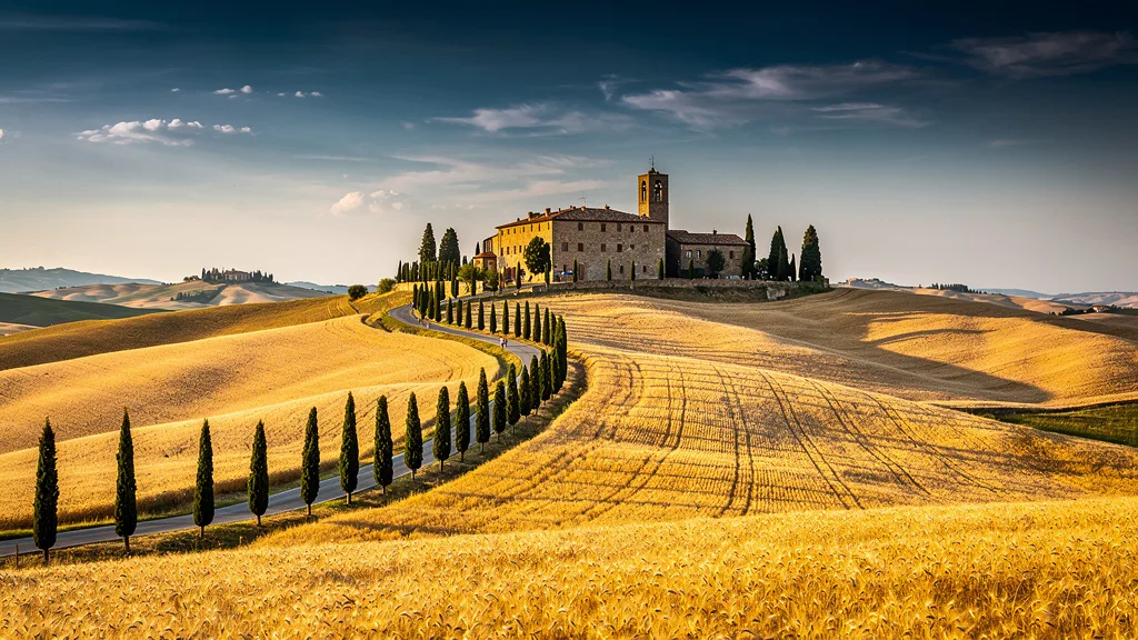
Val d’Orcia: The UNESCO-listed valley south of Siena produces the iconic Tuscan landscape photos you have seen a thousand times. Drive the SP146 from San Quirico d’Orcia to Pienza (8 km of perfect cypress-lined road), visit Pienza for pecorino cheese and Renaissance architecture, and push south to Bagno Vignoni, a hamlet with a thermal pool in the main square instead of a normal piazza. Montalcino, west of Pienza, is the home of Brunello di Montalcino – one of Italy’s greatest red wines. The Fortezza at the top of town has a tasting room; the Enoteca Grotta del Brunello at the bottom of the hill is less touristy.
Umbria: Cross the border from Tuscany and the crowds thin immediately. Perugia is a university city with excellent food (chocolate, cured meats, ceramic markets) and a vibrant evening scene – the Corso Vannucci pedestrianized street fills with Italians strolling in the evening. Assisi needs no introduction – the Basilica of St. Francis is transcendent, and the town at dawn before tour buses arrive is remarkable. Orvieto, perched on a volcanic cliff above the valley, has a cathedral whose mosaic facade alone justifies the drive. The local Orvieto Classico white wine is excellent and costs next to nothing at local shops.
Where to stay: Agriturismi (farm stays) throughout Tuscany and Umbria offer genuine countryside accommodation for EUR 70-130 per night, usually with breakfast from their own garden. Booking through Airbnb or Italian farmstay sites often yields better prices than aggregators.
Practical details:
| Section | Distance | Driving Time | Road Type |
|---|---|---|---|
| Florence to Siena (via Chianti) | 70 km | 1.5 hours | Winding country roads |
| Siena to Pienza (Val d’Orcia) | 55 km | 1 hour | Scenic provincial roads |
| Pienza to Montepulciano | 15 km | 20 minutes | Beautiful hill road |
| Montepulciano to Cortona | 45 km | 50 minutes | Mix |
| Cortona to Perugia | 55 km | 1 hour | Superstrada |
| Perugia to Assisi | 25 km | 30 minutes | Main road |
| Assisi to Orvieto | 80 km | 1.5 hours | Mix of roads |
Best season: April-June, September-October. July and August are hot (35 C+) and busier, though still enjoyable if you drive early in the morning and rest midday.
Route 2: Amalfi Coast and Campania (250 km, 4-5 days)
The SS163 Amalfi Coast road is simultaneously one of the most beautiful and most nerve-wracking drives in Europe. Narrow, winding, with sheer drops to the sea on one side and rock walls on the other, it demands attention. But the views – terraced lemon groves, pastel villages cascading down cliffs, blue sea below – are unmatched anywhere in the Mediterranean.
Itinerary:
Naples (skip the car) – Sorrento (1-2 nights) – Positano – Amalfi (1-2 nights) – Ravello – Paestum – back to Naples
Highlights by section:
Sorrento to Positano is the most dramatic 20 km of road in Italy. The SS163 clings to the cliff with hairpin turns every 100 meters. Buses take up the entire road width, and you will wait while they squeeze past – sometimes you will reverse 50 meters to find a passing point. Positano is the postcard village – multicolored houses tumbling down to a beach, boutiques selling lemon everything, and restaurants with views that justify their prices.
Amalfi has the cathedral (climb the 57 steps), the paper museum (Museo della Carta, genuine and interesting), and a less frantic atmosphere than Positano. From Amalfi, the road inland and uphill to Ravello (6 km) leads to what Gore Vidal called “the most beautiful place in the world.” The Villa Rufolo gardens overlooking the coast are the highlight. The Villa Cimbrone gardens at the far end of town, with their terrace suspended above the sea, are even better.
Paestum (80 km south of Amalfi) has Greek temples that rival anything in Greece itself – three perfectly preserved temples from the 6th and 5th centuries BC, virtually uncrowded. The mozzarella from the surrounding buffalo farms is the freshest you will ever eat. Buy it from a roadside stand on the way back; Tenuta Vannulo is a renowned farm open to visitors.
Practical details:
| Section | Distance | Driving Time | Road Type |
|---|---|---|---|
| Naples to Sorrento | 50 km | 1-1.5 hours | Motorway + coastal |
| Sorrento to Positano | 18 km | 45 minutes | Narrow, winding |
| Positano to Amalfi | 18 km | 40 minutes | Narrow, winding |
| Amalfi to Ravello | 6 km | 15 minutes | Steep switchbacks |
| Amalfi to Paestum | 80 km | 1.5 hours | Mixed |
Best season: April-May or September-October. Summer is brutally congested – July and August traffic makes the already-narrow SS163 an exercise in patience.
Important: In summer (June-September), the Amalfi Coast road operates a one-way alternating system on some days between Positano and Amalfi. Check locally before driving, and consider driving the coast east-to-west (Amalfi to Sorrento) in the morning before the system activates.
Car size matters enormously here. Choose the smallest car available – a Fiat 500 or Fiat Panda fits the road infinitely better than a mid-size. Large vehicles face genuine difficulty on the narrower sections.
Route 3: The Dolomites (350 km, 4-5 days)
The Dolomites are for drivers who love driving. Mountain pass after mountain pass, each one delivering switchbacks, summit views, and descents that test your braking and reward your patience. The landscape is vertical – pale limestone peaks rising 3,000 meters above green valleys. In summer, cycling tours and road cars share these passes; in autumn, the colors turn the valleys golden.
Itinerary:
Bolzano (1 night) – Stelvio Pass – Merano – Sella Pass – Val Gardena – Cortina d’Ampezzo (1-2 nights) – Tre Cime (day trip) – Lake Misurina – Bolzano
Highlights by section:
Stelvio Pass (2,757 meters) is the highest paved road pass in Italy and one of the highest in the Alps. The road has 48 numbered hairpin bends on the Trentino side and 34 on the South Tyrol side. It is a motoring pilgrimage that attracts drivers, cyclists, and motorcyclists from across Europe specifically to drive it. Open roughly June to October depending on snow. The drive up takes about an hour from Prato allo Stelvio and delivers views that escalate with every switchback. At the top: a cafe, souvenir shops, and a crowd of people all photographing the hairpin descent they just drove. Worth it.
Sella Pass and the Sella Ronda loop connect four valleys and four passes in a single 55 km circuit. Passo Sella (2,244 m), Passo Pordoi (2,239 m), Passo Campolongo (1,875 m), and Passo Gardena (2,121 m) – each with a cafe at the summit and views of the distinctive Dolomite limestone towers. The entire loop takes 2-3 hours of driving, not counting stops. Do it in the morning before clouds build.
Val Gardena (Gröden Valley) is a resort valley with the charming towns of Ortisei, Santa Cristina, and Selva. The valley floor has excellent cycling infrastructure and the towns have surprisingly good food – this is South Tyrol, which was Austrian until 1919 and maintains a Germanic food tradition of schnitzel, strudel, and excellent local wines.
Tre Cime di Lavaredo is reached via a toll road (EUR 30 per car) from Misurina. The three limestone towers are the most iconic image of the Dolomites and appear on the covers of more Italian tourism brochures than we can count. Walk the 9 km loop trail at the base for the classic view (2-3 hours, moderate difficulty). The morning light is best – arrive early or you will share the car park with hundreds.
Cortina d’Ampezzo is Italy’s most glamorous ski resort and a pleasant summer base. The town has a pedestrianized main street (the Corso Italia) lined with designer shops and cafes. The 2026 Winter Olympics preparation has brought infrastructure improvements. Useful as a base for Tre Cime and several other Dolomite routes.
Practical details:
| Section | Distance | Driving Time | Road Type |
|---|---|---|---|
| Bolzano to Stelvio Pass | 95 km | 2.5 hours | Mountain road, switchbacks |
| Stelvio to Merano | 70 km | 1.5 hours | Valley road |
| Sella Ronda loop | 55 km | 2-3 hours | Mountain passes |
| Cortina to Tre Cime | 30 km | 1 hour | Mountain + toll road |
| Cortina to Bolzano (via Val Gardena) | 85 km | 2 hours | Mountain valley |
Best season: June-September. Stelvio Pass typically opens in early June and closes in late October. Other passes may open slightly earlier. The Dolomites in June have late snow at high altitude; July and August are perfect.
Route 4: Cinque Terre and the Ligurian Coast (200 km, 3-4 days)
The Ligurian coast between Genoa and La Spezia includes the famous Cinque Terre villages, but also lesser-known gems like Portofino, Camogli, and Lerici. Note: you cannot drive into the Cinque Terre villages themselves (they are accessed by train, boat, or on foot), but a car lets you explore the wider coast at your own pace.
Itinerary:
Genoa (1 night) – Camogli – Portofino (drive to Santa Margherita, walk or boat to Portofino) – Sestri Levante – park at La Spezia or Riomaggiore (1-2 nights for Cinque Terre by train) – Lerici – back to Genoa or continue south to Tuscany
Key stops:
Camogli is the anti-Portofino: a colorful fishing village without the designer shops and yacht crowds. The focaccia from Revello bakery on the main street is legendary – thick, olive-oiled, and sold by the kilo. The beach below the old town is rocky but beautiful.
Portofino itself is tiny and car-free. Park in Santa Margherita Ligure (EUR 2-4/hr in garages) and take the 25-minute walk along the coast path or a water taxi (EUR 5-8). The harbor with painted houses and luxury yachts is quintessential Italian Riviera, and the small church of San Giorgio above the harbor has views over the entire bay.
Cinque Terre: Park your car at La Spezia station or the Riomaggiore parking (EUR 15-25/day) and take the local train between the five villages. Trying to drive to the villages is pointless – the roads are restricted and parking is essentially nonexistent. The Cinque Terre card (EUR 16-18 per day) includes unlimited train travel between villages. The trail between Vernazza and Corniglia is the best of the coastal paths.
Sestri Levante is an underrated stop between Portofino and Cinque Terre – a proper town with two bays, good seafood restaurants, and far fewer tourists than the famous spots. Worth an overnight.
Practical details:
| Section | Distance | Driving Time | Road Type |
|---|---|---|---|
| Genoa to Camogli | 25 km | 35 minutes | Coastal |
| Camogli to Santa Margherita | 10 km | 15 minutes | Coastal |
| Santa Margherita to Sestri Levante | 30 km | 40 minutes | Coastal/Autostrada |
| Sestri Levante to La Spezia | 60 km | 1 hour | Autostrada |
Best season: April-May, September-October. Summer in Cinque Terre is overwhelming with crowds – July and August see the trails busy, villages packed, and trains running at capacity.
Route 5: Sicily Loop (600 km, 7-10 days)
Sicily operates as its own universe. The food is different, the light is different, the pace is different, and the driving is different in ways that require acclimatization. But for sheer density of extraordinary things per kilometer – Greek temples, baroque towns, volcanic landscapes, sea views, and a cuisine that ranks among Italy’s best – Sicily rewards the effort.
Itinerary:
Palermo or Catania (fly in) – Agrigento (1-2 nights) – Ragusa (1 night) – Siracusa (1-2 nights) – Taormina (1-2 nights) – Etna day trip – Palermo or back to Catania
Highlights by section:
Agrigento has the Valley of the Temples – a series of Doric temples from the 5th century BC that are more complete than anything in Greece. The Temple of Concordia is one of the best-preserved Greek temples in the world. Visit at sunset for the best light.
Ragusa and the southeast Baroque (Val di Noto): The 1693 earthquake destroyed most of southeast Sicily and the towns were rebuilt in the same decade, creating a remarkably unified Baroque architectural landscape. Ragusa Ibla, Noto, and Modica are UNESCO World Heritage Sites. The drive between them on provincial roads through dry hills and almond orchards is pure Sicily.
Siracusa was one of the greatest cities in the ancient world. The island of Ortigia (the old town) is a 20-minute walk from end to end and contains Greek temples, a Baroque cathedral, Norman architecture, and one of Sicily’s best food markets. Visit early in the morning.
Taormina is the most overtouristed town in Sicily and still worth the stop. The Greek theater with Etna in the background is the most photographed scene in Sicily. Arrive before 10 AM or after 5 PM.
Etna: Drive up to the cable car station (1,923 m) and then either take the cable car further up or hike. The landscape of recent lava flows – black, alien, and still steaming in places – is genuinely otherworldly. Etna is an active stratovolcano and occasionally closes sections due to activity.
Practical details:
| Section | Distance | Driving Time | Road Type |
|---|---|---|---|
| Palermo to Agrigento | 130 km | 2 hours | A19 motorway |
| Agrigento to Ragusa | 115 km | 1.5 hours | SS115 coastal road |
| Ragusa to Siracusa | 90 km | 1.5 hours | SS194 |
| Siracusa to Taormina | 95 km | 1.5 hours | A18 motorway |
| Taormina to Catania | 55 km | 1 hour | A18 motorway |
Best season: April-June, September-October. July and August are extremely hot (38-42 C in the interior).
Route Comparison Table
| Route | Distance | Duration | Difficulty | Best Season | Highlights |
|---|---|---|---|---|---|
| Tuscany & Umbria | 450 km | 5-7 days | Easy | Apr-Jun, Sep-Oct | Wine, food, hill towns, Val d’Orcia |
| Amalfi Coast | 250 km | 4-5 days | Moderate-Hard | Apr-May, Sep-Oct | Coastal drama, Ravello, Paestum |
| Dolomites | 350 km | 4-5 days | Moderate-Hard | Jun-Sep | Mountain passes, Stelvio, Tre Cime |
| Ligurian Coast | 200 km | 3-4 days | Easy-Moderate | Apr-May, Sep-Oct | Portofino, Cinque Terre, coast |
| Sicily Loop | 600 km | 7-10 days | Moderate | Apr-Jun, Sep-Oct | Temples, Baroque, Etna, food |
Planning Your Road Trip
Which route for first-timers? Tuscany and Umbria. The driving is easy, the rewards are enormous, and the pace is relaxed. You cannot go wrong.
Combining routes: Two weeks allows Tuscany + Amalfi Coast (fly into Florence or Pisa, drive south through Tuscany and Umbria, end in Naples) or Tuscany + Ligurian Coast (loop from Florence or Milan). The Dolomites are best as a standalone trip from Milan, Verona, or Venice.
The ZTL survival strategy: For every city on your itinerary, identify the ZTL boundaries and the nearest parking garage outside them before you arrive. Search “[city name] parcheggio ZTL” for options. This single step can save you EUR 200-500 in fines.
Autostrada vs. free roads: On routes where time matters (getting from Rome to Naples to start the Amalfi drive), take the autostrada. On scenic routes (Tuscany, Umbria, Ligurian coast), take the provincial roads – they are where the beauty lives, and the speed difference is minimal for short distances.
Food strategy: Plan meals around the regions you are driving through. In Tuscany, eat bistecca and local wines. In Umbria, truffles and lentils from Castelluccio. In Campania, fresh mozzarella and pizza margherita. In Sicily, arancini, pasta alla norma, and granita. Italy’s regional food differences are as dramatic as the landscapes.
For driving rules and ZTL details, see our Italy driving guide. For cost planning, check the costs and tips page. And for nearby destinations, our Greece road trips and Slovenia road trips offer complementary Mediterranean and Alpine experiences.
Route 6: Puglia — The Heel of the Boot (400 km, 5-7 days)
Puglia is the Italy that overtourism has not fully discovered yet. The southernmost region of the Italian peninsula has whitewashed trulli villages, baroque cities, sea that shifts from green to deep cobalt, and a food tradition that deserves to be as famous as Tuscany’s. The roads are quiet by Italian standards and the driving is almost universally enjoyable once you leave Bari.
Itinerary:
Bari (base, 1-2 nights) – Alberobello (1 night, trulli) – Locorotondo – Ostuni (1-2 nights) – Lecce (1-2 nights) – Otranto – Gallipoli – back to Bari
Highlights by section:
Bari to Alberobello (55 km, 1 hour): Take the SS100 southeast from Bari. Alberobello’s trulli – conical stone houses with whitewashed walls and grey slate roofs – are UNESCO World Heritage Sites and genuinely extraordinary. The Rione Monti and Rione Aia Piccola districts contain the highest concentration. Get there before 10 AM for photographs without crowds.
The Valle d’Itria trulli triangle: Locorotondo (a circular hilltop town with photogenic streets lined with white houses), Martina Franca (baroque architecture, excellent bread and pork products), and Cisternino (quieter, less-touristed, fine Sunday market) form a loose triangle you can drive between in an afternoon. The landscape between them – dry stone walls, olive groves, trulli in every direction – is Puglia in essence.
Ostuni is the Città Bianca (White City): a hilltop town of chalk-white buildings visible from the coastal plain below. It has good restaurants in the old town and makes a good overnight base for the Valle d’Itria. From Ostuni, the coast is 8 km – the beaches at Torre Canne and Fasano are some of Puglia’s best.
Lecce is the Baroque capital of the south. The city’s pale golden sandstone (pietra leccese) has been carved into an extravagance of Baroque churches, palaces, and piazzas that is unlike anywhere else in Italy. The basilica of Santa Croce is the centerpiece, but the entire historic center rewards extended wandering. Lecce also has a ZTL zone – park outside the center at the Piazza Ariosto parking area and walk in.
Otranto and the Adriatic coast: The town at the heel-tip of Italy with a 12th-century cathedral containing Europe’s largest floor mosaic (the Tree of Life, covering the entire nave floor). From Otranto, the coast road south to Santa Maria di Leuca is dramatic – cliffs, blue sea, and tiny coves.
Gallipoli (not the Turkish one) is a baroque island town connected to the mainland by a short bridge. The old town beaches are the most central in Puglia, and the evening passeggiata on the lungomare is Puglia at its most Italian.
Practical details:
| Section | Distance | Driving Time | Road Notes |
|---|---|---|---|
| Bari to Alberobello | 55 km | 1 hour | SS100, easy driving |
| Alberobello to Ostuni | 45 km | 50 minutes | SP134, valley views |
| Ostuni to Lecce | 90 km | 1 hour | SS16 or SS379 coastal |
| Lecce to Otranto | 40 km | 45 minutes | SP367 coast road |
| Otranto to Gallipoli | 75 km | 1.5 hours | Coastal SS16, scenic |
| Gallipoli to Bari | 180 km | 2 hours | SS101 north |
Best season: May-June, September-October. July and August bring Italian beach tourism en masse to Puglia, and the coast roads (particularly near Gallipoli) can be congested. September is perfect: warm sea, fewer crowds, all restaurants and accommodations still open.
Route 7: Sardinia Coastal Loop (600 km, 7-10 days)
Sardinia is the one Italian destination where a car is not just useful – it is essential. The island’s best beaches and landscapes are accessed by roads that public transport barely touches. Sardinia’s driving is among the most enjoyable in all of Italy: low traffic density, excellent road surfaces, and coastal views that rival the Caribbean.
Itinerary:
Cagliari or Olbia (fly in) – Costa Smeralda – Maddalena Archipelago – Palau – Santa Teresa Gallura – Alghero (1-2 nights) – Bosa (1 night) – Oristano – Nora (day trip) – back to Cagliari or Olbia
Highlights by section:
Costa Smeralda (northeast, from Olbia): The famous emerald coast developed by the Aga Khan in the 1960s. Porto Cervo and Porto Rotondo are the celebrity destinations – expensive restaurants, superyachts, and beaches that are impossibly beautiful. The coast road between Palau and Olbia passes dozens of access points to beaches that put the Amalfi Coast to shame for sea color, with none of the cliff-road stress.
Maddalena Archipelago: From Palau, a 15-minute ferry (EUR 15 per car return) reaches Isola Maddalena. From there, a bridge connects to Isola Caprera (Garibaldi’s home, now a museum). The beaches on the west side of Maddalena have Caribbean-turquoise water in a European setting.
Alghero: A Catalan-speaking (genuinely; the language is still spoken) medieval city on the northwest coast. The old town is pedestrianized and beautiful, the seafood restaurants are excellent, and the surrounding country has the only significant coral reef in the Mediterranean (Neptune’s Grotto, 20 km south by boat or cliff stairs). Alghero makes a perfect 2-night base for the northwest.
Bosa: A small river-mouth town with a medieval castle and a main street that looks like a film set (which it has been). The river road between Alghero and Bosa (50 km, the S291var) is one of the most beautiful coastal drives in Italy – cliff roads, wild hills, and the sea far below. Budget 1.5 hours for this stretch even though it is only 50 km.
Practical details:
| Section | Distance | Driving Time | Road Character |
|---|---|---|---|
| Olbia to Costa Smeralda | 30 km | 35 minutes | Good coastal road |
| Costa Smeralda to Palau | 45 km | 50 minutes | Scenic coast |
| Palau to Alghero (via SS127) | 145 km | 2.5 hours | Mountain interior |
| Alghero to Bosa (S291var) | 50 km | 1.5 hours | Spectacular coast road |
| Bosa to Cagliari (SP49 + SS131) | 180 km | 2.5 hours | Carlo Felice highway |
Best season: May-June, late August-October. July and August are peak season with Italian family tourism filling the beach resorts. Prices triple and beaches at Costa Smeralda get crowded. May and June offer perfect weather with reasonable prices and no crowds. October is exceptional – warm, quiet, and the light is golden.
Sardinia-specific notes: Ferry to Sardinia from mainland Italy departs from Genoa, Civitavecchia (Rome), Livorno, and Naples. Routes operated by Tirrenia, GNV, and Moby Lines. Booking the car on the ferry is essential – car spaces sell out in July and August months in advance. The crossing takes 6-10 hours (overnight ferries available). Alternatively, fly to Cagliari or Olbia and collect a rental car at the airport.
Multi-Week Italy Itinerary (14 Days, North to South)
For a two-week Italian road trip covering the country’s main regions, this north-to-south progression works logically with the rental car flow:
| Day | Location | Driving | Distance |
|---|---|---|---|
| 1-2 | Milan Malpensa pickup + Lake Como day | A8 north | 60 km |
| 3 | Drive to Lake Garda | A4 east | 120 km |
| 4 | Verona – collect toll ticket on A22 south | A22 | — |
| 5-6 | Bolzano, Dolomite pass day (Sella Ronda) | Mountain roads | 100 km |
| 7 | Drive to Venice (park in Mestre) | A22 + A4 | 190 km |
| 8 | Venice by vaporetto (car stays in Mestre) | — | — |
| 9 | Drive to Florence via Bologna | A1 south | 250 km |
| 10-11 | Tuscany countryside (Chianti, Siena, Val d’Orcia) | Country roads | 150-200 km/day |
| 12 | Drive to Rome (park outside GRA) | A1 south | 280 km |
| 13 | Rome by metro (car stays at GRA parking) | — | — |
| 14 | Drive to Naples, return car, fly | A1 south | 225 km |
Total distance: approximately 1,650 km over 14 days. Toll costs: EUR 80-120 total. This route avoids driving in any major city center by design.
Seasonal Route Recommendations
| Month | Best Routes | Avoid | Notes |
|---|---|---|---|
| January-February | Sardinia (off-season quiet), Puglia, Sicily | Dolomites (passes closed) | Mild south, dramatic winter north |
| March-April | Tuscany, Umbria, Puglia | Sicily interior (can be cool) | Wildflowers, Easter, spring best |
| May-June | All routes excellent | Peak urban areas at weekends | Best all-round months |
| July | Dolomites, Ligurian Coast | Amalfi Coast (congested), Sicily interior (41 C+) | North pleasant; south brutal heat |
| August | Sardinia (book ahead), Dolomites | Everywhere else; ferragosto chaos | Book everything 3+ months ahead |
| September-October | Tuscany harvest, Puglia, Sicily | None | Our favorite months in Italy |
| November | Sicily, Sardinia, Puglia coast | Dolomites (closing), Amalfi (rainy season) | Quiet, cheap, genuinely beautiful |
| December | Sicily (mild), Puglia, Rome | Mountain roads (snow possible) | Christmas markets in north if brave |
Day Trip Combinations by Base City
From Florence:
| Day Trip | Distance Round Trip | Drive Time Each Way | Highlight |
|---|---|---|---|
| Siena | 150 km | 1 hour | Piazza del Campo, Palio heritage |
| Pisa | 170 km | 1 hour | Leaning Tower (even jaded travelers are impressed) |
| San Gimignano | 110 km | 1 hour | Medieval towers, Vernaccia wine |
| Volterra | 160 km | 1.5 hours | Alabaster workshops, Etruscan museum |
| Lucca | 140 km | 1 hour | Completely intact city walls you can cycle on top of |
| Montepulciano | 240 km | 1.5 hours | Vino Nobile wine, hilltop perfection |
From Rome:
| Day Trip | Distance Round Trip | Drive Time Each Way | Highlight |
|---|---|---|---|
| Orvieto | 240 km | 1.5 hours | Cathedral facade, underground caves |
| Tivoli | 60 km | 45 minutes | Villa d’Este gardens, Hadrian’s Villa |
| Ostia Antica | 50 km | 40 minutes | Roman port city, less crowded than Pompeii |
| Cerveteri | 80 km | 1 hour | Etruscan necropolis, UNESCO site |
| Sperlonga | 140 km | 1.5 hours | Coastal village, Roman villa |
| Civitavecchia | 80 km | 1 hour | Port + Michelangelo’s Fort |
The ZTL Road Trip Strategy — A Practical Summary
After driving in Italy dozens of times, we have refined our ZTL management approach to a simple decision tree that works every time:
-
Check ZTL hours for every city on your itinerary before you start driving. Five minutes of research prevents EUR 100 fines.
-
Identify the closest parking outside the ZTL. Every Italian city with a ZTL has garages positioned just outside it specifically because locals know visitors need to park there. Search “parcheggio ZTL [city name].”
-
Save parking coordinates in your phone before driving. When you arrive in an unfamiliar city, you do not want to be navigating while also looking for a garage entrance.
-
If staying inside a ZTL, call your hotel. Ask whether they have a parking arrangement or whether they can register your plate. Get the answer in writing (email). A verbal “yes, no problem” from the receptionist who answers the phone is not the same as a confirmed plate registration.
-
Route yourself to the parking first, not to your hotel. Even if your hotel is inside a ZTL, park outside and walk with your bags. One night’s urban hiking beats EUR 300 in camera fines.
-
Keep the plate number accessible. You will need it for parking machines, hotel check-in, ZTL registrations, and occasionally police checks. Taking a photo of the rear number plate before leaving the rental lot solves this problem permanently.