Best Road Trips in United States
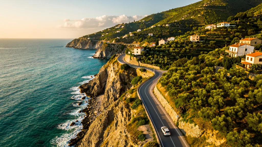
The Pacific Coast Highway between San Francisco and Los Angeles is the drive that convinced us road trips were not just a mode of transportation but a form of art. For 380 miles, Highway 1 traces the California coastline through landscapes that shift every 30 minutes — from the foggy redwood forests north of Santa Cruz, through the dramatic Big Sur cliffs where mountains plunge 1,000 feet into the Pacific, to the golden hills of San Simeon where elephant seals sleep on the beach in plain view of the road. We pulled over 27 times in two days. We counted. The car averaged roughly 40 mph including stops, which is slower than we drive through most European villages, and we did not care. Some roads are not meant to be fast.
America has more iconic road trips than any country on Earth, and for good reason: the country was built around the car, the distances require driving, and the landscape variety — desert, mountain, forest, coast, prairie — provides visual drama that changes with every state line. The infrastructure to support road trips is unmatched: gas stations, motels, diners, campgrounds, and rest areas are available even in the most remote stretches.
What makes American road trips unique is the scale. In Europe, a day’s drive across a country means you have crossed a country. In America, a day’s drive across a state means you have crossed a state, and there are 50 of them. The country was designed for long-distance driving — not adapted to it after the fact, but built around the automobile from the beginning. The Interstate Highway System, launched in 1956, is 48,000 miles of controlled-access highway, the most extensive in the world. It was designed with military efficiency and executed with American ambition. The result is a road network so comprehensive that you can drive coast to coast without hitting a single traffic light on the main route.
Route Comparison
| Route | Distance | Drive Time | Best For | Difficulty |
|---|---|---|---|---|
| Pacific Coast Highway (SF-LA) | 380 miles (610 km) | 2-3 days | Coastal cliffs, Big Sur, beach towns | Easy-Moderate |
| Route 66 (Chicago-LA) | 2,400 miles (3,860 km) | 2-3 weeks | Americana, nostalgia, desert, quirky towns | Easy |
| Blue Ridge Parkway | 469 miles (755 km) | 3-5 days | Mountain scenery, fall foliage, Appalachian culture | Easy |
| Desert Southwest Loop | 1,500 miles (2,400 km) | 7-10 days | Grand Canyon, Monument Valley, Zion, Bryce | Easy |
| Miami to Key West (Overseas Highway) | 160 miles (260 km) | 3-4 hours | Ocean bridges, island hopping, tropical vibes | Easy |
Planning Costs by Route
| Route | Fuel Cost (economy car) | Accommodation Range/night | National Park Passes | Best Time |
|---|---|---|---|---|
| Pacific Coast Highway | $80-120 USD | $80-300 USD | None required | Apr-Oct |
| Route 66 | $280-380 USD | $50-150 USD | Optional (Grand Canyon detour) | Apr-May, Sep-Oct |
| Blue Ridge Parkway | $55-80 USD | $60-200 USD | None (Parkway is free) | Oct (foliage), May-Sep |
| Desert Southwest Loop | $200-280 USD | $70-250 USD | America the Beautiful Pass ($80) | Mar-May, Sep-Nov |
| Miami to Key West | $25-35 USD | $100-400 USD | None | Dec-Apr |
Route 1: Pacific Coast Highway (San Francisco to Los Angeles)
This is the road trip that defines California — and arguably defines the American road trip genre. Highway 1 follows the Pacific coast through some of the most dramatic coastal scenery in the world.
Route details:
- Start: San Francisco
- End: Los Angeles
- Distance: 380 miles (610 km) via Highway 1
- Drive time: 8-10 hours without stops (but stopping is the point)
- Recommended duration: 2-3 days
- Best season: April-October (Big Sur section closes occasionally in winter due to landslides)
| Stop | Miles from SF | Highlight | Suggested Stay |
|---|---|---|---|
| Half Moon Bay | 30 miles | Coastal farm town, whale watching | Lunch stop |
| Santa Cruz | 75 miles | Boardwalk, surfer town, redwoods | 2-3 hours |
| Monterey / Pacific Grove | 115 miles | Aquarium, Cannery Row, 17-Mile Drive | 1 night |
| Big Sur | 150-180 miles | Bixby Bridge, McWay Falls, redwood groves | 1 night |
| San Simeon | 200 miles | Hearst Castle, elephant seal colony | Half day |
| Cambria / Paso Robles | 220-240 miles | Wine country, charming town | 1 night |
| San Luis Obispo | 260 miles | College town, excellent food scene | Lunch stop |
| Santa Barbara | 320 miles | Spanish architecture, wine, beaches | 1 night |
| Malibu | 360 miles | PCH final stretch, celebrity beaches | Drive-through |
| Los Angeles | 380 miles | Arrival | N/A |
Big Sur is the route’s crown jewel. The 90-mile section between Carmel and San Simeon features cliffs dropping hundreds of feet to the ocean, the iconic Bixby Bridge (one of the most photographed bridges in the world, a single arch spanning 700 feet across a coastal canyon at Mile Marker 18.4 on Highway 1), McWay Falls (which drops directly onto a beach that is inaccessible except by view), and redwood groves accessible by short hikes. There are no gas stations in central Big Sur — fill up in Carmel or Cambria. Lodging options are limited (Ventana Big Sur and Post Ranch Inn are luxury properties; camping at Pfeiffer Big Sur State Park is excellent). Book everything months in advance for summer visits.
Monterey Bay Aquarium is worth a half-day stop in its own right. The giant kelp forest tank — three stories high, holding 1.2 million liters of seawater — is one of the great aquarium exhibits in the world. Entry: 50-60 USD. Allow 3-4 hours.
17-Mile Drive in Pebble Beach (17 USD entrance fee) passes through Monterey cypress trees and offers views of the famous Lone Cypress and Pebble Beach golf course. Worth the detour if you are already in Monterey.
The Bixby Bridge stop: Mile Marker 18.4 on Highway 1, 13 miles south of Carmel. The viewpoint is on the north side of the bridge with a small pullout. The south side also has a pullout with slightly different angle. Both are frequently crowded in summer — arrive before 9 AM or after 5 PM for manageable crowds and better light. The bridge spans 714 feet at 260 feet above the canyon floor. It was completed in 1932 and remains the longest open-spandrel arch bridge in California. None of this is visible to the driver because you are focused on not driving off a cliff while looking at it.
Driving notes: Highway 1 through Big Sur is two lanes, winding, and often foggy in morning and evening. Use pullouts to let faster traffic pass. Guardrails are present but the drop-offs are dramatic. The road is not dangerous but demands attention. The stretch near Julia Pfeiffer Burns State Park (McWay Falls) is the most visually spectacular — slow down, use pullouts, and do not drive with your phone in hand for photos. The views will be there tomorrow; the guardrails only hold so much.
Big Sur road closures: The Big Sur section of Highway 1 is periodically closed by landslides, particularly after major rain events in winter and spring. Check Caltrans (dot.ca.gov) for current road conditions before setting out. An alternative route when Highway 1 is closed: US-101 inland through the Salinas Valley, then rejoining Highway 1 at Cambria — adds about 30 miles but avoids the closure.
Route 2: Route 66 (Chicago to Los Angeles)
The “Mother Road” — 2,400 miles of American mythology from the Great Lakes to the Pacific Ocean. Route 66 was decommissioned as a US highway in 1985, but the spirit (and most of the road) remains. Driving it is a journey through American history, nostalgia, and the kind of roadside attractions that only exist in this country.
Route details:
- Start: Chicago, Illinois (starting point: the corner of Adams Street and Michigan Avenue, officially marked)
- End: Santa Monica, California (the pier is the traditional endpoint)
- Distance: ~2,400 miles (3,860 km)
- Drive time: 35-40 hours driving
- Recommended duration: 2-3 weeks
- Best season: Spring (April-May) or fall (September-October)
| State | Key Stops | Highlight |
|---|---|---|
| Illinois | Chicago, Springfield, Chain of Rocks Bridge | Lincoln’s hometown, iconic bridge |
| Missouri | St. Louis, Springfield, Carthage | Gateway Arch, diners, Ozarks |
| Kansas | Galena, Riverton | 13-mile stretch of original road |
| Oklahoma | Tulsa, Oklahoma City, Clinton | Route 66 museums, art deco architecture |
| Texas | Amarillo, Cadillac Ranch | 10 Cadillacs buried nose-first in a field |
| New Mexico | Santa Fe, Albuquerque, Tucumcari | Adobe architecture, neon motels |
| Arizona | Flagstaff, Grand Canyon (detour), Oatman | Wild burros, painted desert, meteor crater |
| California | Mojave Desert, San Bernardino, Santa Monica | Desert crossing, ocean finish |
Cadillac Ranch in Amarillo, Texas, is Route 66 in a single image: ten vintage Cadillacs buried nose-first in a wheat field, covered in spray paint. Visitors are encouraged to add their own paint. It is free, roadside, and inexplicable in the best American way. The Cadillacs were installed by Texan art patron Stanley Marsh 3 in 1974 — he had 10 Cadillacs sourced from 1948 to 1963, arranged at the same angle as the Great Pyramid of Giza (he claimed). Buy cheap spray paint at any hardware store in Amarillo before visiting. The installation is located at 35°11’15”N, 101°59’13”W, 2 miles west of downtown Amarillo on I-40 frontage road.
Tucumcari, New Mexico is the Route 66 motel experience preserved: neon signs, adobe architecture, and mid-century motor courts that were old when Elvis was young. The Blue Swallow Motel (1939) is the most photographed, with its glowing neon sign and original garage doors. Stay here if you can book a room — it books months in advance and the experience is genuinely unlike any hotel chain.
The Grand Canyon detour from Flagstaff adds 160 miles (80 miles each way via AZ-64 north from Williams) but is essentially mandatory. The South Rim is one of the most powerful natural sights in the world — photographs do not prepare you for the scale. The canyon is 277 miles long, up to 18 miles wide, and over a mile deep. The South Rim is accessible by car; the North Rim requires a longer detour and closes in winter (mid-October to mid-May). Entry: 35 USD per vehicle (7-day pass). Timed-entry reservations are now required in advance for popular spots during peak season (May-October) — book at recreation.gov.
Oatman, Arizona is worth a detour: a near-ghost town on one of the last original sections of Route 66, occupied by semi-wild burros that wander the streets demanding carrots from tourists. The town has been populated continuously since a gold rush in 1915. The main street has not changed significantly since the 1940s, which is part of the charm and part of the reason the burros are still there. The road to Oatman from Kingman on the original Route 66 section (AZ-66 over the Black Mountains) is narrow, winding, and spectacular. Most large vehicles avoid it.
Practical notes: Route 66 is not a single continuous road anymore — sections have been replaced by Interstate I-40. You will alternate between the original two-lane road and the modern interstate. Route 66 maps and apps (Road Tripper, Route 66 Navigation App) guide you through the drivable sections.
Route 66 Logistics
Budget differently for Route 66 than other road trips. The accommodation ranges from historic motor courts (40-80 USD/night, atmospheric) to chain motels (60-100 USD/night, reliable). Food along Route 66 is the journey’s pleasure — roadside diners, barbecue joints in Oklahoma, Mexican food in New Mexico, and burger places that have been open since 1955.
Fuel planning: the Midwest and Southwest sections have stretches where stations are 30-50 miles apart. Fill up when you hit half a tank in Arizona and New Mexico. The Mojave Desert final stretch into California is hot, remote, and sparse on services.
Driving east-to-west vs. west-to-east: Most drivers go Chicago to Santa Monica (west). Going east-to-west means you have a strong image of the destination (the Pacific Ocean) pulling you forward. Going east adds the advantage of ending in Chicago with its excellent food scene and easy return flights. Either direction works; the westward direction is more popular because arriving at the Santa Monica Pier and seeing the Pacific for the first time after 2,400 miles is a genuinely satisfying moment.
Route 3: Blue Ridge Parkway
The Blue Ridge Parkway is America’s most scenic road — a 469-mile drive along the crest of the Appalachian Mountains from Virginia to North Carolina. There are no commercial vehicles allowed, no billboards, and a 45 mph speed limit. It exists purely for the pleasure of driving.
Route details:
- Start: Shenandoah National Park (Virginia, near Waynesboro)
- End: Cherokee, North Carolina (Great Smoky Mountains)
- Distance: 469 miles (755 km)
- Drive time: 12-15 hours total
- Recommended duration: 3-5 days
- Best season: October (fall foliage is legendary)
| Mile Post | Stop | Highlight |
|---|---|---|
| MP 0 | Rockfish Gap (start) | Southern end of Shenandoah National Park |
| MP 86 | Peaks of Otter | Mountain lodge, Abbott Lake, Sharp Top hike |
| MP 176 | Mabry Mill | Most photographed spot on the Parkway, working mill |
| MP 217 | Blue Ridge Music Center | Live Appalachian music on weekends |
| MP 305 | Linville Falls | Dramatic gorge waterfall, 2-mile loop trail |
| MP 355 | Mount Mitchell | Highest peak east of Mississippi (6,684 ft / 2,037 m) |
| MP 382 | Folk Art Center | Appalachian crafts and art gallery |
| MP 431 | Waterrock Knob | 360-degree mountain views, sunset destination |
| MP 469 | Cherokee (end) | Gateway to Great Smoky Mountains National Park |
Fall foliage peaks in October and draws millions of visitors. The color display — maples, oaks, and hickories in shades of red, orange, and gold — is among the finest in the world. Book accommodation weeks in advance for October weekends. Asheville, North Carolina (accessible from multiple Blue Ridge Parkway exits, notably from MP 382-388) is the most popular base — a thriving small city with excellent food, craft beer, and easy access to both the Parkway and the Great Smoky Mountains.
Mabry Mill (Mile Post 176) is the Parkway’s most iconic stop — a grist mill and sawmill complex operating in a meadow beside a pond, exactly as it appeared in the early 20th century. Demonstrations of traditional grinding and woodworking run on weekend mornings. The reflections in the millpond photograph magnificently at dawn. The surrounding area has craft vendors on summer weekends. The mill ground corn here from 1910 to 1935; it now demonstrates period operations for visitors.
Mount Mitchell State Park (Mile Post 355, accessible via NC-128 from the Parkway): At 6,684 feet (2,037 m), this is the highest point in the Appalachian Mountains and the highest east of the Mississippi. The summit area has an observation tower, a small museum, and views on clear days that extend into multiple states. A short trail (0.4 miles) from the summit parking area reaches the tower. Weather changes rapidly at this elevation – carry a jacket even on warm lower-elevation days.
Driving notes: The Parkway has a 45 mph speed limit and no gas stations on the road itself. Fill up at towns accessible from exits (the Parkway crosses or approaches US highways every 20-40 miles). The road is two lanes, winding, and can be foggy. Wildlife (deer, black bears, wild turkeys) may be on the road, especially at dawn and dusk. Some sections close in winter due to ice and snow. The Parkway’s closure map (maintained by the National Park Service at nps.gov/blri) shows current conditions — check before setting out in shoulder seasons.
Asheville, North Carolina deserves specific mention as a base for the southern section. Biltmore Estate (America’s largest private home, 8,000 acres, the Vanderbilt family’s 1895 château), a nationally recognized craft brewery scene (Wicked Weed, Hi-Wire, New Belgium), and a downtown arts district that has been genuinely thriving for 20+ years make Asheville one of the most rewarding small cities in the American South. Access the Parkway from the Folk Art Center (MP 382) at the edge of the city.
Route 4: Desert Southwest Loop
A loop through America’s most dramatic desert landscapes — the Grand Canyon, Monument Valley, Zion, Bryce Canyon, and Arches. This is the road trip that makes you understand why American westerns look the way they do.
Route details:
- Start/End: Las Vegas, Nevada
- Loop distance: ~1,500 miles (2,400 km)
- Recommended duration: 7-10 days
- Best season: March-May, September-November (summer is brutally hot)
| Stop | Miles from Las Vegas | Drive Time | Highlight | Suggested Stay |
|---|---|---|---|---|
| Zion National Park | 165 miles | 2.5 hrs (I-15 → UT-9) | Red rock canyons, Angel’s Landing hike | 1-2 nights |
| Bryce Canyon | 250 miles | 4 hrs from LV | Hoodoo formations, sunrise amphitheater | 1 night |
| Capitol Reef | 350 miles | 5.5 hrs from LV | Quiet park, orchards, scenic drive | Half day |
| Arches / Moab | 460 miles | 7 hrs from LV | Delicate Arch, mountain biking, Colorado River | 1-2 nights |
| Monument Valley | 520 miles | 8 hrs from LV | Iconic buttes, Navajo Nation | 1 night |
| Grand Canyon (South Rim) | 670 miles | 10 hrs from LV | The big one | 1-2 nights |
| Sedona | 730 miles | 11 hrs from LV | Red rocks, vortexes, galleries | 1 night |
| Las Vegas | 900 miles | Return | — | N/A |
National Park passes: An America the Beautiful Pass (80 USD) covers entrance to all national parks for one year. With five parks on this route (25-35 USD each), the pass pays for itself immediately. Purchase at the first park gate or at recreation.gov before your trip.
Zion National Park requires a shuttle for main canyon access in peak season (April-October) — private vehicles are not allowed on the canyon floor road. Park at the visitor center and take the free shuttle to your trailhead. Angel’s Landing (requires a permit: 3 USD, obtained via lottery at recreation.gov) is the iconic hike — 5 miles round trip, 1,488 feet elevation gain, with chain-assisted sections on exposed ridgelines. The views are extraordinary. The chains are necessary. People do occasionally fall; this is not the hike to attempt in wet conditions or if you dislike heights. The Narrows (wading through the Virgin River in Zion Canyon’s slot canyon) is the other must-do – no permit required for the bottom-up approach, though water shoes and a walking staff are essentially mandatory.
Bryce Canyon at sunrise is one of the great natural spectacles. The amphitheater contains thousands of hoodoos (spires of rock created by freeze-thaw erosion) illuminated orange and pink in the first light. The sunrise viewpoints (Sunrise Point, Bryce Point) are 10-15 minutes’ walk from the main parking areas. Arrive before first light – the color peaks in the 30 minutes after sunrise.
Arches National Park contains the highest density of natural stone arches in the world – over 2,000 documented arches in 119 square miles. Delicate Arch (46 feet tall, 32 feet wide) is the iconic image, visible only by hiking 3 miles round trip with 480 feet of elevation gain. The hike is genuinely worth the effort. The Windows Section arches are accessible by shorter walks (0.5-1 mile) for those with less time. Timed-entry reservations required April-October during peak hours (6 AM - 5 PM) – book at recreation.gov.
Monument Valley is on the Navajo Nation reservation. The 17-mile scenic drive through the valley of buttes is accessible by rental car (unpaved but manageable in a standard sedan at low speed – drive slowly over the washboard sections). The drive entrance fee is 20 USD per vehicle, paid to the Navajo Nation Tribal Park (not covered by the America the Beautiful Pass). For a deeper experience, Navajo-guided tours reach areas closed to the public.
Water and preparation: Desert driving in any season requires water (1 gallon per person per day minimum). Cell phone coverage is patchy in southern Utah and the Navajo Nation. Carry a paper map as backup. Gas stations can be 80+ miles apart on some stretches.
Summer Warning
Summer (June-August) temperatures in the desert Southwest regularly reach 100-115°F (38-46°C). Hiking in these temperatures is dangerous, not merely uncomfortable. Arches National Park closes the most popular trails at 10 AM when temperatures exceed 100°F. Plan outdoor activity exclusively for early morning (before 09:00) and late evening (after 18:00) during summer months.
Route 5: Miami to Key West (Overseas Highway)
The shortest route on this list but one of the most unique: 160 miles across 42 bridges connecting the Florida Keys, ending at the southernmost point in the continental United States.
Route details:
- Start: Miami
- End: Key West
- Distance: 160 miles (260 km)
- Drive time: 3-4 hours without stops
- Recommended duration: 2-3 days
- Best season: December-April (dry season)
| Stop | Mile Marker | Distance from Miami | Highlight |
|---|---|---|---|
| Key Largo | MM 100 | 60 miles | Diving/snorkeling capital, John Pennekamp State Park |
| Islamorada | MM 80 | 80 miles | Sport fishing, Robbie’s (feed the tarpon) |
| Marathon | MM 50 | 110 miles | Seven Mile Bridge — the iconic crossing |
| Bahia Honda | MM 37 | 123 miles | Best beach in the Keys |
| Big Pine Key | MM 33 | 127 miles | Key deer (miniature deer, endangered) |
| Key West | MM 0 | 160 miles | Duval Street, Hemingway House, sunset at Mallory Square |
Seven Mile Bridge is the highlight of the drive — literally a road across open ocean. The old bridge (opened 1912) runs parallel and is now used as a pedestrian walkway and fishing pier. The new bridge spans 35,716 feet (6.77 miles) across open water. The view from the bridge, with nothing but water in every direction, is surreal. This is one of those driving experiences that works as a photograph but works better in person, when you realize there is no land visible in any direction and you are driving on a strand of concrete that has been engineered to sit in hurricane-prone tropical water for decades.
Robbie’s of Islamorada (Mile Marker 77.5) is one of the Florida Keys’ most entertaining stops — you pay 3 USD to feed tarpon (large silver fish, 4-6 feet long) from the dock. The tarpon leap for bait fish held at arm’s length, which sounds mild until a 100-pound fish surfaces next to your hand. Worth 30 minutes and the complete ruination of your socks.
John Pennekamp Coral Reef State Park (Key Largo, MM 102.5) is the first undersea park in the United States and one of the best snorkeling sites on the East Coast. Glass-bottom boat tours (30 USD) and snorkel tours (30 USD) depart regularly. The reef systems here are accessible within 3 miles of shore and contain staghorn coral, brain coral, and abundant fish life. The park also has a 2.5-mile walking trail through a mangrove hammock.
Key West is the reward: a walkable, quirky, subtropical town with excellent food, Hemingway’s six-toed cats (descendants of the original six-toed cats Hemingway kept; about 40-50 live at the Hemingway Home and Museum, 14 USD entry, 907 Whitehead Street), and a nightly sunset celebration at Mallory Square that draws street performers, artists, and approximately half the island’s population. The southernmost point marker (a concrete buoy at the corner of Whitehead and South Streets) is 90 miles from Cuba and the most photographed corner in Florida. Parking in Key West is expensive and limited – use the Mallory Square garage (nearest to most attractions) or park on the street with caution regarding the 2-hour limits.
Traffic warning: The Overseas Highway is a single road with no alternative routes. Holiday weekends (especially Memorial Day and July 4th) create bumper-to-bumper traffic that can double or triple drive times. Travel on weekdays. The stretch between the Florida Turnpike junction (near Homestead, where US-1 narrows to a two-lane highway) and Key Largo is the most reliably congested on weekends – locals and experienced Keys visitors know to travel before 8 AM or after 7 PM on holiday weekends.
Hurricane season awareness: The Florida Keys sit in the direct path of Atlantic hurricanes (June-November). In the event of an approaching storm, the Keys issue mandatory evacuation orders and US-1 becomes a one-way evacuation route. If traveling during hurricane season, monitor NOAA forecasts and know the evacuation procedures.
Planning Tips
Car choice: America’s roads accommodate any vehicle. For western desert loops, a sedan works fine — no SUV needed for paved roads. For mountain drives (Blue Ridge Parkway), any car with functioning brakes is adequate. The only situation requiring a specific vehicle is unpaved roads in national parks (some require high clearance). Monument Valley’s scenic drive, for example, works in a standard sedan driven carefully.
National Park reservations. Popular parks (Zion, Glacier, Rocky Mountain, Arches) now require timed-entry reservations during peak season. Book online 2-3 months ahead at recreation.gov. Without a reservation, you may be turned away at the gate. The reservation system is a significant change from the pre-2020 era when you could simply show up.
Gas station strategy. In the West, distances between stations can be long. Fill up when you hit half a tank. In the East and Midwest, stations are everywhere. Apps like GasBuddy show current prices at every station on your route and can identify cheaper options nearby.
Accommodation. America offers every price point. Budget motels (Motel 6, Super 8) cost 60-100 USD per night. Mid-range hotels (Hampton Inn, Holiday Inn Express) run 100-180 USD. National park lodges (if you can book them – Ahwahnee in Yosemite, El Tovar at the Grand Canyon) are 250-500 USD and typically sell out 6+ months ahead. Camping in national parks costs 20-35 USD per night and provides the best access to parks – reserve through recreation.gov.
Food strategy. American road trip food has improved dramatically. Beyond fast food, look for local diners, barbecue joints (Southeast and Texas), taco trucks (Southwest and California), and farm-to-table restaurants in small towns. The quality-to-price ratio at American roadside food is often excellent.
Timing your departures. For Pacific Coast Highway, begin in San Francisco to have the option of pulling over whenever you want without holding up traffic behind you. For the Desert Southwest loop from Las Vegas, start with Zion (going east) so you reach the Grand Canyon on day 5-6 when you have already calibrated your distances and driving pace.
Interstate vs. scenic routes: The US Interstate system gets you between cities efficiently but shows you nothing. US highways (US-1, US-101, US-66) and state routes (CA-1, UT-12, NC-181) are where the landscape is. Budget more time for scenic routes – they are the reason you are road-tripping rather than flying.
UT-12 honorable mention: We would be remiss not to mention Utah Route 12 between Torrey and Bryce Canyon (112 miles, 2-3 hours). It passes through Grand Staircase-Escalante National Monument, over the Hogback ridge (a knife-edge section with 1,000-foot drops on both sides), and through red rock canyon country that rivals anything in the National Park system. It is not on the main Desert Southwest loop itinerary but is worth the detour if you have an extra day between Capitol Reef and Bryce Canyon.
For driving rules and practical details, see our US driving guide. For cost planning, check car rental costs in the US. For airport pickup procedures, our US airport rental guide covers the major hubs.